Cercana Executive Briefing: Week of April 18–24, 2026

153 feeds monitored. Published April 24, 2026.
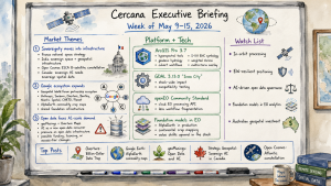
Executive Summary

This was a week in which the geospatial industry seemed to be looking in two directions at once. On one side, companies are accelerating toward AI-native products, platforms, and data pipelines. On the other, Ed Parsons raised a harder question about whether AI world models may eventually absorb some of the value that traditional geospatial infrastructure has long claimed for itself.

That tension gives the week its shape. Parsons, one of the industry’s most credible independent voices, argued that AI “world models,” spatial representations embedded inside large neural networks, may be developing into an implicit replacement for parts of traditional geospatial data infrastructure. This is not a claim that GIS disappears tomorrow. It is more interesting, and more uncomfortable, than that. The claim is that the industry’s foundational assumption, that knowledge of the world must pass through explicit, structured, georeferenced data, may no longer be as secure as it once seemed.

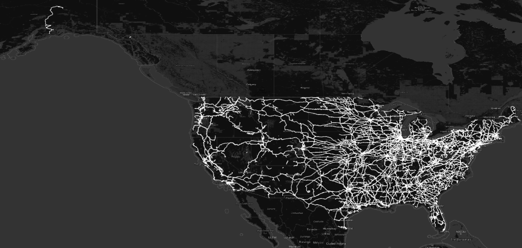
The timing made the argument harder to dismiss. Google Maps Platform announced AI-powered imagery tools. L3Harris and Xoople unveiled a “next-generation spaceborne measurement system for the AI era.” EarthDaily marked a record six-satellite launch with Loft Orbital. The pattern is hard to miss: the EO and geospatial platform industries are racing to build AI-native capabilities at the same time that an emerging line of thought questions whether those investments eventually converge on terrain that AI companies absorb from below.

The rest of the week filled in the picture. Biodiversity and nature-related risk continued to look less like a niche sustainability topic and more like a forming commercial EO vertical. GeoServer 3.0 reached release candidate status. The Panoramax Foundation was formally announced. Multiple national reference frame modernization efforts advanced in parallel. Taken together, it was a week where the sector’s near-term growth story ran into its longest-horizon disruption scenario.

Major Market Signals

AI World Models and the Long-Range Platform Risk

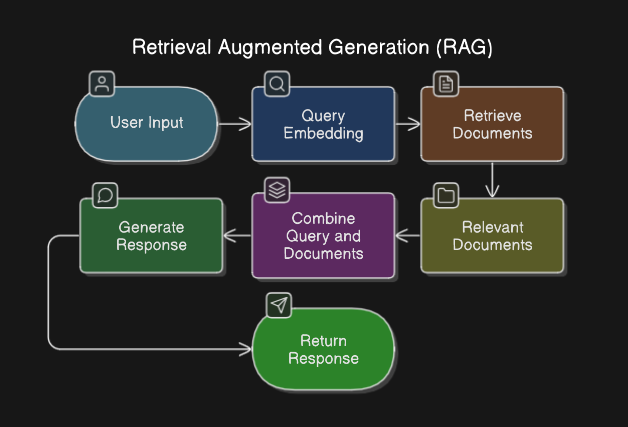
Ed Parsons published a carefully argued piece this week positing that AI “world models,” large neural networks that learn implicit spatial representations of the physical world without relying on explicit geographic data layers, may ultimately be a deeper disruption than anything the geospatial industry has previously faced.

The important part of the argument is not technological novelty. The industry has seen plenty of that. The more important part is that world models challenge the geospatial sector’s theory of value. For decades, the working assumption has been that reliable knowledge of place requires explicit geospatial data: layers, coordinates, attributes, schemas, indexes, projections, services, and standards. That assumption has been productive. It built the modern GIS and EO industries. But if large AI systems develop useful internal representations of physical reality, some downstream users may care less about whether the system consults a conventional geospatial dataset and more about whether it produces a reliable answer.

That is why this matters for executives. The companies investing most heavily in world models, including Google, Meta, and major robotics firms, are not primarily buying geospatial data products. They are building systems that may eventually make some classes of geospatial product less visible, less differentiated, or less necessary in downstream workflows. The post landed the same week Google announced AI-powered imagery tools for Maps Platform, which reinforced rather than weakened the point. Leaders in data, platform, and analytics businesses do not need to treat this as an immediate operational threat, but they should treat it as a strategic thesis worth tracking.

EO Platforms Racing to AI-Native Architecture

The near-term story is much more straightforward: Earth observation providers are rebuilding their value chains around AI-native data delivery.

Five separate announcements this week, from different parts of the market, pointed in that direction. EarthDaily and Loft Orbital announced a record six-satellite coordinated launch, explicitly tied to EarthDaily’s AI analytics pipeline. L3Harris and Xoople announced a new spaceborne measurement system they describe as “purpose-built for the AI era.” Google expanded Maps Platform with AI-powered imagery processing. LiveEO’s Twinspector satellite duo, offering 35cm-class stereo, is aimed at infrastructure operators who need machine-parseable change detection.

The common thread is not simply better imagery. Better imagery is the familiar story. The newer story is imagery packaged, processed, and delivered so that AI systems can use it with less human mediation. That matters because procurement conversations are likely to shift. Resolution and revisit rate will still matter, but buyers are increasingly going to ask whether a data stream fits into an AI pipeline, whether it reduces preprocessing burden, and whether it can support production operations rather than isolated demonstrations.

Biodiversity and Nature-Risk Forming as a Commercial EO Vertical

Biodiversity and nature-related risk are starting to look like a real commercial EO market rather than a category held together by conference language.

Three announcements this week pointed in the same direction. CATALYST, backed by the UK Space Agency, launched a pilot with DUAL UK to develop a satellite-enabled biodiversity risk assessment tool for the insurance industry. Airbus Defence and Space was named technical partner in the Coffee Canopy Partnership with JDE Peet’s, using satellite imagery to map worldwide coffee plantations for supply chain risk monitoring. Ordnance Survey released a ready-to-use land and habitat data tool to support Biodiversity Net Gain compliance under UK planning regulations.

These are different buyers with different motivations, but the underlying need is similar. Insurers, agricultural supply chains, developers, and regulators all need auditable spatial evidence about nature-related exposure and compliance. TNFD, the Taskforce on Nature-related Financial Disclosures, is helping to create that demand, but regulation is not the only driver. Supply chain risk, underwriting discipline, and land-use policy are all pulling in the same direction. Expect more EO companies to test this vertical in the second half of 2026 as reporting expectations and compliance timelines become more concrete.

Reference Frame Modernization Advancing Simultaneously Across Multiple Countries

Reference frames rarely make for splashy market narratives, but they are one of the places where geospatial infrastructure becomes impossible to ignore.

A cluster of positioning stories this week showed that a coordinated, if unplanned, global refresh of geodetic reference systems is underway. The final GPS III satellite reached orbit, with Lockheed Martin already advancing work on the next-generation GPS IIIF. In Canada, GoGeomatics published a detailed analysis of CSRS modernization and its implications for critical infrastructure under NATRF2022. The transition affects everything from pipeline monitoring to autonomous vehicle routing. In the U.S., Esri published guidance for ArcGIS Pro users preparing for NSRS 2022, the impending American datum modernization.

These are not software updates. They are changes to the coordinate foundations on which software, data, field operations, engineering records, and compliance workflows depend. Reference frame transitions introduce systematic coordinate offsets that propagate through spatial datasets an organization already owns. For utilities, logistics providers, construction firms, autonomous systems developers, and any company with positioning-dependent operations, this is an active risk management issue. It should not be left as a background concern for the GIS team to discover late.

Open Data Matures Into a Fitness-for-Purpose Debate

The open data conversation is also maturing. That does not mean openness matters less. It means openness is no longer enough.

Two analytically aligned posts this week made that point from different directions. The Cloud Native Geo blog argued that usefulness is a better measure of data quality than openness, describing a landscape where data abundance has not translated into insight availability because the bottleneck is now integration, fitness-for-purpose, and supply chain reliability. A Medium piece made the same point from the EO side, arguing that most Earth observation projects fail not because of model quality but because no one builds the data supply chain underneath them.

This is familiar to practitioners, but it is only slowly entering the policy conversation. Open data mandates are valuable, but they do not solve deployment. A dataset can be legally open and still be operationally unusable. It can be accessible and still be poorly documented, inconsistently maintained, expensive to integrate, or misaligned with the decision it is supposed to support. That distinction matters for government open data programs and for commercial data companies that want to compete on curation, delivery, and reliability rather than raw access.

Notable Company Activity

Product Releases

  • Esri: Released ArcGIS Maps SDK 2.3 for both Unreal Engine and Unity, extending 3D geospatial capabilities for game engine-based digital twin and simulation use cases. Esri also released the April 2026 update to ArcGIS for Microsoft 365, continuing its push to embed spatial analytics in familiar enterprise productivity environments.
  • GeoSolutions Group: Released GeoServer 3.0 Release Candidate, a major milestone for the widely deployed open-source WMS/WFS server. Full coverage appears in the Open Source section below.
  • Mergin Maps: Shipped feature filtering for its QGIS-based mobile field data collection platform. Users can now filter map features by attribute values directly in the field application, addressing a common need in survey and inspection workflows.
  • Google: Added AI-powered imagery tools to Maps Platform, with possible downstream effects for geospatial workflows. Specific details on the feature set are limited in available coverage, but the announcement presents this as a developer-facing capability rather than a consumer update.

Partnerships

  • EarthDaily × Loft Orbital: Marked what both companies describe as a record coordinated launch of six EarthDaily satellites, deepening the relationship between EarthDaily’s analytics pipeline and Loft Orbital’s hosted payload infrastructure.
  • L3Harris × Xoople: Announced a next-generation spaceborne measurement capability described as designed for the AI era, combining L3Harris sensor hardware with Xoople’s software stack. Public technical detail remains limited, but the market framing suggests a defense-adjacent product targeting precision measurement at scale.
  • SSC Space × Kuva Space: Signed a Letter of Intent to strengthen Nordic space capabilities across infrastructure, mission development, and security applications. This fits a broader pattern of European space capability consolidation.
  • Point One Navigation × EuroTeleSites: Expanded high-precision location services across Southeastern Europe, using EuroTeleSites tower infrastructure as a corrections delivery network.
  • Airbus Defence and Space × JDE Peet’s: Named as technical partner in the Coffee Canopy Partnership for worldwide plantation mapping using satellite imagery and AI analytics.
  • CATALYST × DUAL UK: Launched a UK Space Agency-funded pilot to develop a satellite-enabled biodiversity risk scoring tool for insurance underwriting.

Government and Policy Developments

Geoscience Australia completed a meaningful milestone this week: the AUSTopo 1:250,000 digital map series, begun in 2023, now covers the entire Australian continent. This is not merely a cartographic update. It is the completion of a national spatial data foundation that supports emergency management, resource planning, and infrastructure investment across one of the world’s largest landmasses. The timing matters because Australia faces increasing climate-driven event frequency. A complete, current topographic base is one of the prerequisites for the next generation of risk modeling tools.

In Canada, GoGeomatics published the third installment of a detailed series on CSRS modernization, focusing on what the NATRF2022 transition means for critical infrastructure operators. The analysis identifies systematic displacement risks for pipelines, rail, and utilities whose spatial records were captured under the legacy Canadian Spatial Reference System. This is a compliance and risk management issue that has not yet received attention proportional to its potential operational consequences.

The U.S. Census Bureau’s American Community Survey released its 20th anniversary data update to 2020–2024 five-year estimates. For the first time, four comparable five-year periods spanning two decades are available simultaneously. PolicyMap covered the release in detail. For organizations using ACS data in site selection, housing analysis, community development, or equity mapping, this creates a useful longitudinal resource.

In the United Kingdom, Ordnance Survey released a land and habitat data tool designed to help developers and local authorities comply with Biodiversity Net Gain requirements under UK planning law. The tool is intended to accelerate the government’s 1.5 million homes target by reducing the time required to generate BNG assessments. That places OS in the middle of planning reform infrastructure, not merely in the background as a data provider.

Internationally, PLACE published a piece on its work with the SDG Data Alliance and a Global Data Hub supporting small island nations. The piece is a reminder that data sovereignty and spatial infrastructure gaps remain acute for some of the most climate-exposed geographies. It also shows that the donor and development community is still trying to close those gaps through trusted intermediaries rather than relying solely on commercial platforms.

Technology and Research Trends

The most analytically substantive technology piece of the week was a post on MLOps for GeoAI, specifically addressing why standard machine learning drift detection fails in Earth observation contexts. The argument is straightforward but important: landscapes change. Vegetation grows, cities expand, fields rotate, seasons shift, storms alter coastlines, and infrastructure appears or disappears. EO model inputs drift for physical reasons that have nothing to do with a broken data pipeline.

That is a real production problem, and it is often missed in ML discussions written for non-spatial contexts. Its appearance in a practitioner-oriented post suggests that GeoAI deployment maturity is advancing. The conversation is moving from “can we train a model on satellite data” to “how do we keep it working after deployment.” That is the right question. The market for MLOps tooling designed around spatial model drift is likely to become meaningful over the next two to three years.

A complementary piece addressed the architecture of automated, real-time GeoAI pipelines, describing the shift from static GIS layers to event-driven, streaming spatial systems using computer vision and edge inference. Taken together with the MLOps piece, the takeaway is that EO data science and production geospatial systems engineering are beginning to converge into a recognizable discipline. That is a healthy development. It moves the conversation away from demos and toward operational systems.

On the foundational data side, a tutorial covering machine learning cloud pixel regeneration using Sentinel-2 and Sentinel-1 SAR fusion in Google Earth Engine received meaningful attention. Techniques like this, using SAR data to reconstruct optical pixels obscured by cloud cover, have been in research for years. Their arrival in accessible practitioner-oriented tutorials suggests they are moving toward operational use by applied teams.

The Spatial Edge newsletter addressed tile optimization: reducing map tile file sizes without sacrificing visual fidelity. That may sound mundane, but it is the kind of mundane that matters at scale. For organizations operating large consumer or enterprise mapping applications, tile size is a cloud cost, performance, and user experience issue.

Open Source Ecosystem Signals

GeoServer 3.0 reached Release Candidate status this week, announced by GeoSolutions Group. GeoServer is one of the most widely deployed open-source geospatial servers in the world, underpinning a substantial share of WMS, WFS, and WCS infrastructure in enterprise and government environments. The 3.0 milestone follows an extended development cycle and represents a major modernization of the codebase.

For organizations running GeoServer 2.x, the practical message is simple: begin planning. The 3.0 release will likely carry dependencies and deployment changes that require time to test. Open-source infrastructure often disappears into the background when it works, which is one reason upgrade planning can lag. This is not a place to wait until the release is already in production elsewhere.

The QGIS project published security enhancements to its plugin repository this week, following QEP 409, published in January 2026. The changes address plugin code review practices and tighten the working processes around third-party contributions. This matters beyond the QGIS community. QGIS plugins are a meaningful attack surface for organizations that deploy QGIS in enterprise settings, and improved repository governance reduces the risk of supply chain-style compromise through malicious or poorly maintained plugins.

Panoramax, the open street-level imagery platform developed as an alternative to proprietary services like Google Street View, announced the formal creation of a Panoramax Foundation. OpenCage published an interview with founder Christian Quest covering the rationale and roadmap. The Foundation structure is notable because it mirrors the governance path of successful open geo projects, including OSGeo and the OpenStreetMap Foundation. It also signals that Panoramax is moving from promising project to stewarded infrastructure.

For organizations evaluating street-level imagery sourcing, especially in privacy-sensitive or public-sector contexts, that matters. Panoramax is now a structured, foundation-backed option rather than an interesting project to watch from the sidelines.

Watch List

  • DARPA Heavy Lift Challenge / UAV Heavy Lift: UAVOS announced it is supplying high-performance rotor blades to U.S. startup teams competing in DARPA’s Heavy Lift Challenge. If viable, heavy-lift UAV platforms create EO and logistics use cases that current fixed-wing and multirotor UAVs cannot serve. This is worth tracking as an emerging capability layer.
  • Nordic Space Infrastructure Consolidation: The SSC × Kuva Space LOI is the latest in a pattern of Nordic-region space capability agreements. Europe’s push toward strategic space autonomy is producing a quiet consolidation among smaller national players. Similar LOIs and JVs in the Baltic and Nordic regions would not be surprising through 2026.
  • Insurance Industry + EO Convergence: The CATALYST/DUAL UK biodiversity pilot and earlier ICEYE-linked parametric insurance work suggest the insurance sector is moving from experimental EO adoption to structured procurement. If major reinsurers begin requiring spatial evidence for nature-related risk assessment, EO demand could scale rapidly through the insurance value chain.
  • Panoramax Foundation: The formal Foundation announcement elevates Panoramax from a project to a governance structure. Adoption by OpenStreetMap contributors and European public-sector clients will be important to watch. Early institutional uptake would confirm Panoramax as a genuine platform-scale alternative to proprietary street-level imagery.
  • Geospatial Workforce Identity Pressure: Geospatial FM published the second chapter of a series on “moral injury” in the geospatial profession. This is an early indication of workforce sentiment around the AI transition. If the topic recurs, it could point to talent retention and role-clarity issues that affect hiring and team structure at geospatial organizations over the next 12–24 months.

Top Posts of the Week

  1. The Map of Dreams: Why AI’s “World Models” might be the Geospatial Industry’s Ultimate Disruption, Ed Parsons. The most strategically provocative post of the week, arguing that AI-embedded spatial representations could ultimately displace the need for explicit geospatial data products in key use cases.
  2. Loft and EarthDaily Mark Record Launch with Six Satellites, EarthDaily Blog. The industry’s most AI-forward EO company marked a significant constellation expansion, strengthening its argument that EO analytics should be AI-native from the ground up.
  3. Beyond Open Data: Usefulness is a better measure of quality than openness, Cloud Native Geo. A timely argument that the open data paradigm has matured to the point where fitness-for-purpose matters more than licensing, with consequences for both data policy and commercial data strategy.
  4. GeoServer 3.0-RC is here, GeoSolutions Group. A major milestone release that will affect upgrade planning for a significant share of enterprise and government geospatial infrastructure.
  5. CSRS Modernization and Critical Infrastructure: What’s at Stake for Canada, GoGeomatics. The clearest available summary of the operational risks the NATRF2022 reference frame transition poses for Canadian infrastructure operators, and a useful template for how similar transitions should be communicated in the U.S. and elsewhere.

Cercana Executive Briefing is generated from 153 feeds aggregated by geofeeds.me.

Cercana Executive Briefing — Week of April 11–17, 2026

153 feeds monitored. Published April 17, 2026.

Executive Summary

The defining story of this week is a convergence that both practitioners and strategists should track closely. Multiple independent demonstrations of AI agents operating inside QGIS arrived at the same time that QGIS 4.0.1 achieved full cross-platform availability. As demonstrated this week in Germany, Spain, and by independent practitioners, LLMs connected via the Model Context Protocol can execute 28 analytical steps inside the world’s most-deployed open-source GIS from a single text prompt. That development begins to shift the skill profile required for geospatial analysis in ways that will take years to fully understand. The critical counterpoint, voiced bluntly in a widely shared Medium piece titled “AI Hasn’t Landed for the Working GIS Analyst,” is that current tools are still not reliable under production conditions. Leaders should watch this gap between demonstration and deployment carefully because it defines both the opportunity and the risk.

The AI story is also advancing from a different direction. Earth foundation model infrastructure is maturing into deployable data systems. A billion-scale SAR model, planetary-scale pixel embedding compression for real-time change detection, and on-orbit AI processing demonstrations from Planet Labs and Belgian startup EDGX all point toward the same underlying change: geospatial intelligence is moving toward an automated, machine-read pipeline and away from a purely human-supervised workflow. OGC’s completion of its Rainbow research initiative this week offers institutional acknowledgment of that reality. Its conclusion was clear: human-readable standards cannot scale to automated systems.

The week’s funding picture supports the same thesis. Capella received $48.9M for tactical space communications, Earth Blox raised £6M for EO-based climate risk, and Plume raised $3.9M for AI-driven renewable energy site intelligence. Together, those moves suggest that governments and institutional investors increasingly view geospatial data as critical infrastructure for both defense and the energy transition.

Major Market Developments

AI Agents Enter GIS Workflows at Visible Scale

Multiple independent sources this week demonstrated AI agents autonomously executing complex GIS analysis inside QGIS. A Spanish GIS blog covered QGIS MCP, which integrates the Model Context Protocol with QGIS and allows Claude AI to drive analytical workflows through natural language commands. A German community blog highlighted a video demonstration in which a single prompt generated a complete map through 28 autonomous agent steps in 15 minutes. A third post covered LandTalk.AI, which brings Gemini and ChatGPT into QGIS map interpretation. These examples do not come from a single vendor or a coordinated campaign. Instead, they reflect an organic, distributed discovery moment across the QGIS user community. The strategic implication is substantial. If agentic GIS reaches production reliability, the barrier to performing complex geospatial analysis drops, the total market for geospatial intelligence expands, and demand for traditional GIS analyst roles may compress. At the same time, a blunt critical assessment published this week argues that AI tools still fail in practice when they encounter real-world geospatial data structures. The opportunity is real, but the timeline for reliable deployment remains unclear.

Earth Foundation Models Move From Research to Infrastructure

This week’s edition of The Spatial Edge covered a billion-parameter foundation model for SAR (synthetic aperture radar) image understanding. This is a breakthrough because SAR is the all-weather, day-night workhorse of serious Earth observation, yet it is notoriously difficult to train AI on because of speckle noise and geometric distortions. In parallel, GeoSpatial ML published the third installment of a series on compressing Earth embeddings using the Clay v1.5 foundation model, demonstrating per-pixel change detection served from static object storage at planetary scale. Alpha Earth embedding behavior across stable and changing land cover classes was also analyzed independently this week. Taken together, these posts show a sector that is no longer asking only whether the technology works. The question now is how to deploy it at scale. That marks a move from research into engineering. Organizations that depend on large-area monitoring for insurance, agriculture, or defense should be asking their vendors where they stand on foundation model integration.

On-Orbit AI Processing Reaches Commercial Demonstration

Planet Labs selected Alice Springs as the test site for a demonstration of on-board satellite AI, processing imagery at 500km altitude immediately after capture to identify aircraft without downlinking to ground first. Belgian startup EDGX launched its STERNA AI edge computing system into orbit on SpaceX’s Transporter-16 mission, designed for scalable deployment across satellite constellations. Spire also deployed a dedicated satellite for continuous Earth magnetic field mapping as part of the MagQuest challenge. These simultaneous moves, across different missions and vendors, point away from the traditional “collect then process” architecture and toward edge intelligence at the point of collection. The operational implications are profound: reduced latency for time-sensitive intelligence, lower ground station bandwidth requirements, and a new performance differentiation axis for EO vendors beyond resolution and revisit frequency.

Geospatial Standards Bodies Pivot to Machine-Readable Infrastructure

The OGC published the findings of its multi-year Rainbow research initiative this week and shifted the discussion into implementation. The core finding: standards written for human readers do not scale to a world where machines must interpret and act on geospatial data directly. The implementation phase introduces machine-readable Building Blocks and Profiles as modular, traceable components. That changes how geospatial interoperability specifications are written and consumed. In parallel, Phase 1 of the S-100 maritime data framework entered into force globally, allowing the maritime community to begin implementing next-generation chart specifications. Together, these developments suggest that the geospatial standards landscape is being redesigned around machine consumption. That matters for any organization procuring or building automated geospatial pipelines.

Notable Company Activity

Product Releases

  • SimActive: Released Correlator3D Version 11 with native Gaussian splatting integration, enabling photogrammetry workflows to produce high-quality 3D splat models from imagery. This significantly expands deliverable formats for survey and construction clients.
  • Mach9: Released Digital Surveyor 2, an AI feature extraction platform designed to address the bottleneck of converting LiDAR point clouds into engineering-usable features at scale. Geo Week News assessed it as addressing a genuine and growing pain point for survey and civil engineering teams.
  • Foursquare: Published detailed use cases for FSQ Spatial Agent, positioning the product as eliminating the technical barrier between domain experts and complex geospatial analysis by pairing reasoning AI with the FSQ H3 Hub data platform, with no GIS expertise required.
  • Giro3D (Oslandia): Released Giro3D 2.0, a major update to the open-source browser-based 3D geospatial visualization library, adding GPU-side processing for HD LiDAR and 3D Tiles with support for React and Vue.js integration.
  • MapTiler: Released OpenMapTiles 3.16 with improved road connectivity and enhanced dark-mode styling.

Partnerships

  • KSAT × Kongsberg NanoAvionics: Announced a strategic partnership to streamline smallsat mission deployment, reducing operational and financial burden for satellite operators by integrating ground station services with mission management from a single provider.
  • Hexagon × Vale: Hexagon’s R-evolution unit has begun aerial 3D mapping flights under the Green Cubes Digital Reality initiative, creating digital twins to support environmental reclamation across Vale’s mining operations in Brazil. This is a notable application of digital twin technology to ESG obligations at industrial scale.

Funding & M&A

  • Capella Space: Awarded $48.9M for advanced tactical space communications in low Earth orbit. It is a defense-oriented contract that reinforces Capella’s positioning at the intersection of SAR and government intelligence.
  • Earth Blox: Raised £6M for its climate risk platform built on Earth observation data. This is institutional capital chasing the intersection of EO and climate financial risk.
  • Plume: Raised $3.9M to build AI geospatial agents for renewable energy site intelligence. This niche is directly tied to the pace of energy transition investment.

Government and Policy Developments

The OGC’s Rainbow initiative represents the most consequential standards development of the week. The multi-year project, backed by EU Horizon Europe funding and partners including ESA, NRCan, UKHO, and NGA, concluded that geospatial standards must become machine-readable to support an automated world. The move to Building Blocks and Profiles as modular, machine-parseable components will take years to propagate through procurement and compliance requirements. Organizations building automated geospatial pipelines should track this transition closely because it will eventually reshape how contracts are specified and systems are certified.

The global S-100 maritime data standard Phase 1 entering into force is a parallel marker of the same structural shift. Shipping, port management, and maritime defense organizations should begin planning for the transition from traditional ENC chart formats to the S-100 product family.

In Europe, development of EuroCoreReferenceMap — a high-value large-scale geospatial dataset for EU policymakers — is underway, highlighting continued EU investment in sovereign spatial data infrastructure. In Canada, the OGC Canada Forum and the GeoIgnite conference are both building institutional momentum around digital sovereignty and national data connectivity. K2 Geospatial’s sponsorship of GeoIgnite under an explicit digital sovereignty banner reflects how Canadian vendors are positioning themselves around the theme.

The GeoAI and the Law newsletter provided a detailed analysis of California Governor Newsom’s Executive Order N-5-26, signed March 30, which places AI safety and accountability requirements into state procurement contracts rather than creating new legislation. This procurement-driven governance model effectively reaches every vendor selling AI-enabled products or services to California state government, including geospatial AI vendors, and may become a template for other states and federal agencies.

India’s Geospatial World published a substantive interview on India’s defence geospatial transformation, presenting space and geospatial technologies as central to strategic autonomy. The interview highlights a decade of accelerating integration of geospatial capability into military decision-making, indigenization policy, and international collaboration, underscoring India’s emergence as an increasingly important geospatial market for both data and platform vendors.

Technology and Research Trends

The technical direction of travel this week centers on three converging developments: agentic GIS, foundation model operationalization, and cloud-native format adoption in production environments.

On agentic GIS, the QGIS MCP ecosystem is developing rapidly without a single vendor driving it. That is a community-level adoption pattern, which historically has been more durable than vendor-led adoption in the geospatial sector. For technology leaders, the question is not whether AI-assisted GIS workflows will become standard. The real questions are how fast that happens and what reliability threshold organizations will require before they depend on these tools for consequential decisions.

On foundation models, the week’s most technically substantive post was GeoSpatial ML’s DeltaBit piece, which demonstrated pixel-level change detection at planetary scale by compressing Clay v1.5 Earth embeddings to a density suitable for browser-based serving. The engineering ambition of making dense per-pixel embeddings available to any user at global scale would fundamentally change how change detection products are built and delivered. The Spatial Edge’s coverage of the SAR billion-parameter model adds weight to the broader pattern that foundation models designed for EO data are becoming production-grade.

On cloud-native formats, a detailed case study from Swiss consultancy EBP described integrating InSAR ground deformation data into Switzerland’s national natural hazard platform using COG, PMTiles, Parquet, and DuckDB. This is the kind of production case study that turns format advocacy into demonstrated operational value. In a government infrastructure context, the combination of those four tools is also a useful measure of the cloud-native stack’s maturity.

Open Source Ecosystem Developments

QGIS 4.0.1 resolved a Mac distribution issue and is now fully available across platforms. The 4.0 release cycle is drawing intense practitioner attention as the community works through migration and workflow adaptation.

More important over the long term was a pair of posts from OPENGIS.ch, maintainers of QField and major QGIS contributors, articulating and publishing results from their #sustainQGIS initiative. In 2025, the firm invested 168 hours in QGIS maintenance work that included bug fixes, code reviews, refactoring, and test coverage. The funding mechanism is built into their commercial support contracts. Unused hours are donated, and a portion of every multi-day contract is reserved for initiative work. This “sustainability by contract” model addresses one of open source’s most persistent vulnerabilities: maintenance work that delivers no visible features but remains essential to long-term software health. Enterprise QGIS users who depend on the platform for mission-critical workflows should understand this model and consider whether their own procurement practices support or undermine it.

Giro3D 2.0 from Oslandia is a notable open-source release. It is a browser-based 3D visualization library with GPU-accelerated LiDAR and 3D Tiles support that is now integrated into production React and Vue.js applications. PostGIS issued simultaneous security patches across versions 3.2 through 3.6.

Watch List

  • Gaussian Splatting as a Production Survey Deliverable: SimActive’s Correlator3D v11 integrates Gaussian splatting natively, and Geo Week News published a dedicated analysis. This novel 3D representation technique is entering commercial photogrammetry after emerging from research. It is a potential disruptor to traditional point cloud and mesh formats worth tracking in survey and AEC workflows.
  • California AI Procurement Model: If California’s procurement-driven AI governance approach scales, it creates a de facto compliance requirement for geospatial AI vendors selling to government. Watch for adoption in other states and potential federal influence.
  • Celeste Constellation: The first two of eleven planned Celeste testbed satellites launched this week to supplement Galileo. European sovereign positioning infrastructure is developing a second track beyond Galileo itself.
  • Plume + Renewable Energy Site Intelligence: The $3.9M raise for AI geospatial agents targeting renewable energy siting taps into the energy transition capital cycle. A small seed round, but the product thesis — AI agents replacing manual geospatial analysis for site selection — is the same thesis as FSQ Spatial Agent applied to a high-growth vertical.
  • Apple Maps and Geopolitical Cartography: Apple denied this week that it removed Lebanese towns and villages from Apple Maps in connection with the Israeli invasion — a story that generated significant social media attention. The incident reflects growing scrutiny of how commercial map providers handle politically sensitive geographic representation. This is a reputational and regulatory risk vector for any organization operating consumer-facing mapping products.

Top Posts of the Week

  1. QGIS MCP: conecta Claude AI con QGIS y automatiza tu flujo de trabajoMappingGIS — The most shared practical demonstration this week of LLM-driven GIS automation; the clearest articulation of what agentic QGIS looks like in practice for a non-technical audience.
  2. A billion-scale model for understanding radar imagesThe Spatial Edge — Covers multiple converging EO AI research developments including the SAR foundation model, global 1m forest canopy heights from Meta/WRI, and cloud-free imaging advances; the week’s best single-source EO research summary.
  3. From Research to Implementation: Building Shared Infrastructure for an Automated WorldOpen Geospatial Consortium — OGC’s formal announcement of its shift from research to implementation of machine-readable geospatial standards. This is a consequential development with long-horizon procurement implications.
  4. GeoAI and the Law NewsletterSpatial Law & Policy — Detailed analysis of California’s procurement-driven AI governance order; the most substantive policy analysis of the week for geospatial AI vendors serving government.
  5. QGIS Sustainability Initiative – Annual ReportOPENGIS.ch — A rare transparent accounting of how a commercial QGIS services firm funds open-source maintenance. It is directly relevant to any enterprise organization assessing the sustainability of its QGIS dependency.

Cercana Executive Briefing is generated from 153+ feeds aggregated by geofeeds.me.

From Archive to Map: Processing Geospatial Data with Claude Cowork

Using an AI desktop agent can handle data engineering steps so you can get straight to analysis.

Open geospatial data is more accessible than ever, but “accessible” doesn’t always mean “ready to use.” Large datasets frequently arrive as chunked, compressed files that need to be inventoried, understood, and consolidated before they can be loaded into a GIS. That’s exactly the kind of repetitive, multi-step data wrangling that Claude Cowork was built for.

This post walks through a short workflow that takes US railroad line data from the HIFLD Open archive on Source Cooperative — five compressed GeoJSON chunks — and turns it into a single, analysis-ready GeoParquet file that opens directly in QGIS 4.0.

Step 1: Locate the Source Data

After downloading, the starting point is a folder called railroads, containing five GeoJSON files compressed as .gz archives — chunk0000 through chunk0004 — ranging from roughly 3 to 6 MB each. This is a typical delivery format for large vector datasets from Source Cooperative, where data is partitioned into manageable chunks for efficient downloading.

At this stage the data is opaque. You know what it’s called, but not what’s inside, how it’s structured, or whether it’s ready to use. Before touching any GIS tool, it’s worth understanding what you actually have. This is where we open Claude Cowork and get to work.

Step 2: Ask Claude to Summarize the Dataset

Rather than manually decompressing and inspecting each file, the user simply asks Claude to summarize the folder contents. Within seconds, Claude reads through the chunked files and returns a concise description: the dataset contains US railroad lines (RRTE feature class), stored as MULTILINESTRING geometries in NAD-83 decimal degrees, with metadata embedded and the full dataset spanning the contiguous United States.

This step matters more than it might seem. Knowing the geometry type, CRS, and feature class upfront means no surprises when you go to load or reproject the data — and it takes about ten seconds.

Step 3: Merge All Chunks into a Single GeoParquet File

With the dataset understood, the next step is consolidation. The user gives Claude a single instruction: merge all five chunks into one GeoParquet file. What follows is a small but complete autonomous workflow.

Claude first determines what Python libraries it needs — geopandas to read the compressed GeoJSON files and write GeoParquet, pyarrow as the required columnar backend, and pyogrio for faster file I/O. Since these aren’t available in the base environment, it creates a virtual environment, installs the dependencies via pip, and then writes a Python script that globs all .geojson.gz files in the folder, reads each one into a GeoDataFrame, concatenates them, confirms the CRS is set to EPSG:4326, and calls to_parquet() to write the output. It then executes the script and verifies the result by reading the file back and printing a summary.

The result is a single .geoparquet file (~2 MB, gzip-compressed) with geometry type MULTILINESTRING, CRS confirmed as EPSG:4326 (WGS84), and the bounding box spanning the contiguous United States. Full CRS metadata is embedded in the file itself — no sidecar files, no manual projection setup. GeoParquet is an ideal target format for exactly this reason: it’s compact, column-oriented, and natively supported by GeoPandas, DuckDB — and as of QGIS 4.0, directly in the desktop GIS itself, with no intermediate conversion required.

It’s worth noting that all of the above processing happened in the background. By the time we are viewing the geoparquet file in Finder, the python venv has been been completely torn down and deleted.

Step 4: Visualize the Result in QGIS 4.0

The merged GeoParquet file loads directly into QGIS 4.0 without any additional processing. Rendered against a dark basemap, the US railroad network comes into immediate focus — dense corridors in the eastern half of the country, clear transcontinental routes running west, and the unmistakable shape of a century-plus of infrastructure investment.

The map is a confirmation as much as a visualization: the data is clean, the geometry is valid, the projection is correct, and the full national extent is present. Everything worked.

What This Workflow Means

The four steps above took a few minutes. Without an AI assistant, the same process of locating and auditing chunked files, writing a merge script, handling CRS differences, and outputting to the right format could easily take an hour, especially if you’re working across unfamiliar data sources.

Claude Cowork handles the data engineering layer: reading, interpreting, transforming, and validating. The GIS practitioner stays focused on the geographic question they actually want to answer.

The HIFLD Open archive on Source Cooperative is a rich source of authoritative US infrastructure data. Pair it with a capable AI assistant and a modern GIS desktop, and the path from raw download to ready-to-analyze layer is shorter than it’s ever been.

The term “GeoAI” can mean a lot of things, but it doesn’t have to mean releasing your entire production workflow to AI. Tools such as Claude Cowork are making targeted AI workflows more accessible to knowledge workers without the need for writing additional code. They provide a means to streamline rote tasks while enabling analysts to focus their expertise on core problems.

Three Geospatial AI Myths Federal Buyers Should Not Believe

April Fools’ Day is as good a time as any to talk about geospatial AI, because there is still a surprising amount of wishful thinking in the market.

Some of it is harmless marketing shorthand. Some of it is not. For federal buyers, the difference matters. Procurement decisions made on inflated claims can leave agencies with brittle systems, poor data quality, and very expensive disappointment.

So, in the spirit of the day, here are three geospatial AI myths federal buyers should stop believing.

Myth 1: “AI will replace your GIS analysts”

It will not.

What AI can do, and increasingly does well, is accelerate parts of geospatial work that are repetitive, labor-intensive, or structurally well-bounded. That includes things like feature extraction from imagery, draft attribute population, metadata assistance, document entity extraction, semantic search, and automated QA/QC flagging for human review. Those are real gains, and they matter. They can make analysts faster, reduce backlog, and shift staff time toward higher-value work. But that is augmentation, not replacement (Pierdicca et al., 2025; Mansourian et al., 2024).

The part vendors often glide past is that geospatial work is rarely just data processing. It is judgment. It is fitness-for-use. It is understanding whether a dataset, workflow, or model output is actually suitable for a mission context. Federal geospatial programs do not succeed because someone can draw a polygon quickly. They succeed because someone knows whether that polygon should be trusted, how it was derived, what its limitations are, and what the consequences are if it is wrong.

That is why current federal AI policy still centers governance, risk management, testing, and monitoring rather than simple automation narratives. OMB’s current guidance requires agencies to manage risk in AI use cases, and its acquisition guidance emphasizes contract terms for ongoing testing and monitoring. NIST’s AI Risk Management Framework likewise treats validity, reliability, explainability, accountability, and transparency as core characteristics of trustworthy AI systems. More broadly, that emphasis is consistent with a longer-running federal concern that agencies need stronger governance around how data and technology are managed in practice, not just optimistic adoption narratives (National Institute of Standards and Technology, 2023; Office of Management and Budget, 2025a, 2025b; U.S. Government Accountability Office, 2020).

The practical question for federal buyers is not whether AI removes analysts. It is whether it makes analysts more effective without removing the controls that make their work defensible.

Ask vendors:

  • Where do humans stay in the loop?
  • What does analyst review look like in practice?
  • What happens when the model encounters unfamiliar data or edge cases?
  • What are the false positive and false negative rates?
  • Can the system be tested on our data before procurement?

If a vendor cannot answer those questions clearly, the “replacement” story is usually just a maturity problem wearing a marketing jacket.

Myth 2: “Our AI understands geography”

Usually, it does not. At least not in the way geospatial professionals mean it. Large language models can recognize place names, infer rough spatial relationships from training data, and produce plausible-sounding geographic language. That can be useful. They can help with geocoding workflows when paired with external validation, extract geographic entities from documents, generate natural-language descriptions of geospatial content, and route requests to the right tools. That is a meaningful capability. But it is not the same thing as spatial reasoning (Mansourian et al., 2024; Pierdicca et al., 2025).

Actual geospatial understanding requires more than knowing that Annapolis is in Maryland or that rivers flow downhill. It requires handling coordinate reference systems, projections, topology, scale, measurement, uncertainty, and the consequences of transforming data from one spatial framework into another. Those are not side issues. They are the work.

Recent research in LLM-enabled GIS is promising, but the stronger examples generally do not rely on a pure language model acting alone. They connect the model to external GIS tools, geospatial databases, scripted workflows, or validation layers. In other words, the most credible systems are not “the model understands geography.” They are “the model helps drive software that actually does geospatial work.”

Federal buyers should be very careful here, because this is where demo theater often flourishes. A chatbot that talks fluently about maps is not necessarily capable of performing sound spatial analysis. There is a large gap between linguistic confidence and geospatial competence.

Ask vendors:

  • Does the system rely on external geospatial databases and tools, or only on an LLM?
  • How does it handle coordinate transformations?
  • How does it deal with ambiguous place names?
  • What happens when topology, buffering, area, or network calculations are required?
  • Can you show the exact toolchain used for a spatial result?

If the answer is basically “trust the model,” that is not a geospatial AI strategy. That is a procurement warning sign.

Myth 3: “AI-generated geospatial data is production-ready”

Sometimes it is operationally useful. That is not the same thing as production-ready. AI-extracted features, auto-generated metadata, inferred attributes, and synthetic data can all play a useful role in geospatial workflows. But the word to keep in mind is assistive. These outputs can accelerate review, expand triage capacity, and help agencies focus expert attention where it matters most. What they should not do is bypass validation in mission-critical settings.

This is not an abstract concern. NIST frames trustworthy AI around validity, reliability, accountability, transparency, and explainability, all of which become especially important when outputs are used in operational or public-facing contexts. OMB’s acquisition guidance also points agencies toward contractual mechanisms for testing and monitoring over time, not just acceptance at delivery (National Institute of Standards and Technology, 2023; Office of Management and Budget, 2025b).

That matters because geospatial AI systems can produce outputs that look convincing while still being wrong. A computer vision model can miss features or invent them. Metadata generation can sound polished while omitting essential limitations. Synthetic attributes can appear statistically tidy while being operationally misleading. A confidence score can help, but only if there is a real workflow behind it that routes low-confidence or ambiguous outputs to human review.

This is where federal buyers should push hardest. Not on the happy path. On failure.

Ask vendors:

  • What validation workflow is included?
  • How do you measure and report accuracy?
  • Can we review incorrect output examples?
  • What happens at low confidence?
  • What kind of explainability is available to reviewers and auditors?
  • What monitoring exists after deployment?

A vendor who only wants to show perfect outputs is telling you less than they think.

What federal buyers should look for instead

The best geospatial AI vendors are usually the ones least interested in magic. They will show you where the model helps and where it does not. They will be explicit about toolchains, validation steps, and performance limitations. They will welcome testing on your data. They will talk about governance, monitoring, and human review without treating those things as inconvenient objections.

That posture aligns much better with where federal policy already is. Government guidance is not built around blind faith in AI. It is built around risk management, trustworthiness, accountability, and context-of-use. That is a much healthier frame for buying geospatial AI than the current crop of sweeping claims (National Institute of Standards and Technology, 2023; Office of Management and Budget, 2025a, 2025b).

So the simple rule is this: the vendors most confident in their systems should be willing to demonstrate them transparently on your data, discuss limitations openly, and show where humans remain essential.

If they will not, that is probably the most useful signal you are going to get.

For federal organizations trying to separate durable capability from AI theater, that evaluation work is becoming part of the job. It requires more than technical curiosity. It requires a clear view of mission fit, data readiness, governance, procurement risk, and where AI can actually improve operational outcomes. That is exactly the kind of problem strategic advisory and applied AI/ML support should help solve.

At Cercana Systems, this is the kind of work we help clients think through: where geospatial AI fits, where it does not, and how to evaluate, pilot, and implement it with a clear understanding of mission context and operational risk.

References

Office of Management and Budget. (2025a). Accelerating Federal Use of AI through Innovation, Governance, and Public Trust (M-25-21). Executive Office of the President.

Office of Management and Budget. (2025b). Driving Efficient Acquisition of Artificial Intelligence in Government (M-25-22). Executive Office of the President.

Mansourian, A., Pilesjö, P., Harrie, L., and others. (2024). ChatGeoAI: Enabling geospatial analysis for public through natural language, with large language models. ISPRS International Journal of Geo-Information, 13(10), 348.

National Institute of Standards and Technology. (2023). Artificial Intelligence Risk Management Framework (AI RMF 1.0) (NIST AI 100-1). U.S. Department of Commerce.

Pierdicca, R., Zingaretti, P., Frontoni, E., and others. (2025). On the use of LLMs for GIS-based spatial analysis. ISPRS International Journal of Geo-Information, 14(10), 401.

U.S. Government Accountability Office. (2020). Data governance: Agencies made progress in establishing governance, but need to address key milestones (GAO-21-152).