Geospatial-Ready AI Starts with Data Operations

The next phase of GeoAI is moving beyond model access. Most organizations already have access to capable models, cloud infrastructure, and enough software to build a demonstration. As those demonstrations move closer to operational use, the harder question is whether the underlying geospatial data can support real decisions.

Organizations do not get better geospatial AI by adding a model to weak data operations. They get it by making geospatial data easier to find, trust, combine, validate, and govern.

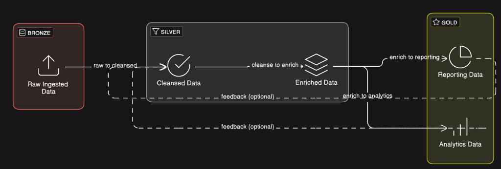
That shifts the work back to the operating discipline behind the data. Teams need to know where a dataset came from, whether it is authoritative for the decision at hand, how it can be combined with other layers, and how its quality has been checked. Those practices determine whether AI-generated spatial output can be used responsibly.

Geospatial data has always carried context that is easy to flatten. A parcel layer, elevation model, or imagery product carries the circumstances of its creation, the timing of its updates, and the purpose it was meant to support. Those details shape whether the data is suitable for a specific decision. A model may summarize, classify, infer, or recommend from that data, but the underlying constraints remain. In some cases, the speed and coherence of the output can make those constraints easier to miss.

Many organizations can already produce plausible spatial answers with AI. The next test is whether they understand the inputs, assumptions, and limitations well enough to use those answers in workflows that affect assets, services, risk, or investment.

That is where data operations become strategic. An organization that knows where its authoritative layers come from, how often they are updated, and which sources support which decisions has a stronger starting point than one that treats spatial data as a collection of files. That operating discipline changes how quickly teams can evaluate new tools, how confidently they can automate decisions, and how well they can explain the results.

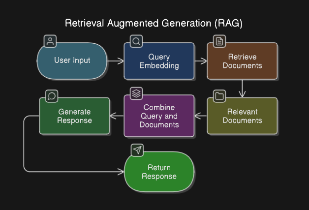
The professional and standards communities are moving in the same direction. Recent guidance around responsible AI, enterprise AI governance, and AI-ready geospatial infrastructure points toward a common conclusion: operational AI depends on documented risk, accountable workflows, reusable standards, and clear stewardship of the data that feeds the system. The model sits inside that larger system.

For geospatial leaders, that creates a practical set of questions. They need to know which datasets are authoritative, where quality is checked, and which layers are ready for automated use. They also need clear ownership for updates and exceptions, along with a shared understanding of when a spatial result is strong enough to support a decision.

GeoAI makes these long-standing questions harder to postpone.

The organizations best positioned to benefit from GeoAI will treat data readiness as part of the system from the beginning. They will know which data deserves confidence, how it can be combined, where uncertainty remains, and when the result is good enough to act on.

AI-ready geospatial infrastructure starts before the model, with the operating discipline needed to make spatial data usable, explainable, and trustworthy at the point of decision.

If your organization is preparing for GeoAI, start with the data foundation. Cercana’s data engineering services help teams organize, validate, integrate, and govern geospatial data so it can support real operational decisions.

Geospatial Without Maps

When most people hear “geospatial,” they immediately think of maps. But in many advanced applications, maps never enter the picture at all. Instead, geospatial data becomes a powerful input to machine learning workflows, unlocking insights and automation in ways that don’t require a single visual.

At its core, geospatial data is structured around location—coordinates, areas, movements, or relationships in space. Machine learning models can harness this spatial logic to solve complex problems without ever generating a map. For example:

  • Predictive Maintenance: Utility companies use the GPS coordinates of assets (like transformers or pipelines) to predict failures based on environmental variables like elevation, soil type, or proximity to vegetation (AltexSoft, 2020). No map is needed—only spatially enriched feature sets for training the model.
  • Crop Classification and Yield Prediction: Satellite imagery is commonly processed into grids of numerical features (such as NDVI indices, surface temperature, soil moisture) associated with locations. Models use these purely as tabular inputs to predict crop types or estimate yields (Dash, 2023).
  • Urban Mobility Analysis: Ride-share companies model supply, demand, and surge pricing based on geographic patterns. Inputs like distance to transit hubs, density of trip starts, or average trip speeds by zone feed machine learning models that optimize logistics in real time (MIT Urban Mobility Lab, n.d.).
  • Smart Infrastructure Optimization: Photometrics AI employs geospatial AI to enhance urban lighting systems. By integrating spatial data and AI-driven analytics, it optimizes outdoor lighting to ensure appropriate illumination on streets, sidewalks, crosswalks, and bike lanes while minimizing light pollution in residential areas and natural habitats. This approach not only improves safety and energy efficiency but also supports environmental conservation efforts (EvariLABS, n.d.).

These examples show how spatial logic—such as spatial joins, proximity analysis, and zonal statistics—can drive powerful workflows even when no visualization is involved. In each case, the emphasis shifts from presenting information to enabling analysis and automation. Features are engineered based on where things are, not just what they are. However, once the spatial context is baked into the dataset, the model itself treats location-derived features just like any other numerical or categorical variable.

Using geospatial technology without maps allows organizations to focus on operational efficiency, predictive insights, and automation without the overhead of visualization. In many workflows, the spatial relationships between objects are valuable as data features rather than elements needing human interpretation. By integrating geospatial intelligence directly into machine learning models and decision systems, businesses and governments can act on spatial context faster, at scale, and with greater precision.

To capture these relationships systematically, spatial models like the Dimensionally Extended nine-Intersection Model (DE-9IM) (Clementini & Felice, 1993) provide a critical foundation. In traditional relational databases, connections between records are typically simple—one-to-one, one-to-many, or many-to-many—and must be explicitly designed and maintained. DE-9IM extends this by defining nuanced geometric interactions, such as overlapping, touching, containment, or disjointness, which are implicit in the spatial nature of geographic objects. This significantly reduces the design and maintenance overhead while allowing for much richer, more dynamic spatial relationships to be leveraged in analysis and workflows.

By embedding DE-9IM spatial predicates into machine learning workflows, organizations can extract richer, context-aware features from their data. For example, rather than merely knowing two infrastructure assets are ‘related,’ DE-9IM enables classification of whether one is physically inside a risk zone, adjacent to a hazard, or entirely separate—substantially improving the precision of classification models, risk assessments, and operational planning.

Machine learning and AI systems benefit from the DE-9IM framework by gaining access to structured, machine-readable spatial relationships without requiring manual feature engineering. Instead of inferring spatial context from raw coordinates or designing custom proximity rules, models can directly leverage DE-9IM predicates as input features. This enhances model performance in tasks such as spatial clustering, anomaly detection, and context-aware classification, where the precise nature of spatial interactions often carries critical predictive signals. Integrating DE-9IM into AI pipelines streamlines spatial feature extraction, improves model explainability, and reduces the risk of omitting important spatial dependencies.

Harnessing geospatial intelligence without relying on maps opens up powerful new pathways for innovation, operational excellence, and automation. Whether optimizing infrastructure, improving predictive maintenance, or enriching machine learning models with spatial logic, organizations can leverage these techniques to achieve better outcomes with less overhead. At Cercana Systems, we specialize in helping clients turn geospatial data into actionable insights that drive real-world results. Ready to put geospatial AI to work for you? Contact us today to learn how we can help you modernize and optimize your data-driven workflows.

References

Clementini, E., & Felice, P. D. (1993). A model for representing topological relationships between complex geometric objects. ACM Transactions on Information Systems, 11(2), 161–193. https://doi.org/10.1016/0020-0255(95)00289-8

AltexSoft. (2020). Predictive maintenance: Employing IIoT and machine learning to prevent equipment failures. AltexSoft. https://www.altexsoft.com/blog/predictive-maintenance/

Dash, S. K. (2023, May 10). Crop classification via satellite image time-series and PSETAE deep learning model. Medium. https://medium.com/geoai/crop-classification-via-satellite-image-time-series-and-psetae-deep-learning-model-c685bfb52ce

MIT Urban Mobility Lab. (n.d.). Machine learning for transportation. Massachusetts Institute of Technology. https://mobility.mit.edu/machine-learning

EvariLABS. (2025, April 14). Photometrics AI. https://www.linkedin.com/pulse/what-counts-real-roi-streetlight-owners-operators-photometricsai-vqv7c/