
Cercana Executive Briefing — Week of August 29–September 4, 2026

166 feeds monitored. Published Friday, September 4, 2026.

Executive Summary

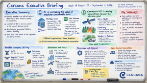
The strongest signal in this week’s feeds was a growing emphasis on infrastructure that makes data directly usable by machines. The Cloud-Native Geospatial Forum launched Portolan, an open-source specification and toolkit for publishing geospatial data as well-organized files in object storage. On the commercial side, Safe Software disclosed a 15 percent headcount expansion and attributed its growth in part to customers discovering that the hard part of AI isn’t necessarily the model; it’s getting the underlying data into shape. The two aren’t evidence of the same market behavior, but they point in the same direction: reducing the friction between stored data and machine consumption is becoming more important.

A second, narrower pattern showed up in commercial Earth observation. Three unrelated announcements — a 25 cm tasking marketplace, a wildfire-likelihood model sold to an insurer, and lidar-derived vegetation risk pushed to utility field crews — all move closer to the buyer’s decision point rather than simply selling imagery. None discloses revenue or customer outcomes, so this is evidence of positioning, not yet demand.

There was no disclosed geospatial M&A or venture funding in the feeds reviewed, and procurement news reached the corpus only secondhand. The next question for the first signal is whether serverless publishing and similar approaches spread beyond the communities building them. CNG events in late September and early October should offer an early test.

Major Market Signals

AI is increasing the value of infrastructure that makes data machine-consumable

Observed. On September 2, the Cloud-Native Geospatial Forum launched Portolan: a specification, validator (rashid), CLI, agent skills, and public registry for publishing geospatial data as GeoParquet, PMTiles, and COG in S3-compatible storage, with STAC metadata and mandatory README and AGENTS.md documentation. The post cites Fields of the World, a 369 TB catalog that served 106.6 TB in the 28 days to August 27 with no dedicated serving layer in front of it. On August 31, Chris Holmes released geoparquet-io 1.4.0 and credited Portolan conversion work with much of the progress since 1.0.

Separately, Spatial Source reported on September 3 that Safe Software plans 60 hires by year-end, taking headcount past 400. The company says it reached CA$100 million in revenue last year against a CA$250 million target for 2028. Its CEO attributed some of the demand to customers discovering that the model isn’t the hardest part of AI. An FME blog post the same week made a similar argument for utility AI projects.

Interpretation. Portolan and geoparquet-io are part of one technical workstream. Safe Software is independent commercial evidence of a related problem. The connection isn’t that serverless SDI and data preparation are the same thing. It’s that both reduce the distance between data as stored and data as consumed by software, analytics, and AI systems. As machine-generated query volumes rise, that layer becomes more important.

Alternative explanation. Safe’s disclosed hiring skews toward sales, revenue operations, and marketing, which also looks like a growing private company scaling go-to-market. The AI framing may be positioning rather than the cause of growth, and its figures are self-reported and unaudited. Portolan’s release also precedes CNG NYC on September 24 and the CNG Forum on October 6–9, so its timing may reflect the event calendar as much as market readiness.

Implication. Data publishers can test the Portolan architecture on fairly concrete terms: storage and egress costs, operational complexity, and performance compared with a dedicated serving tier. More broadly, vendors whose value proposition depends on standing up proprietary serving infrastructure now have to contend with increasingly capable alternatives built around open formats and object storage.

Confidence: Medium. Watch: a national mapping agency adopting Portolan or a similar architecture as an official publication path; Esri’s response in ArcGIS publishing workflows; Safe reporting AI-attributed revenue rather than headcount.

Commercial EO is moving downstream toward the decision point

Observed. Three unrelated announcements this week point in that direction. SI Imaging Services partnered with SkyFi to make native 25 cm SpaceEye-T tasking orderable through SkyFi’s web, mobile, API, and MCP interfaces; Spatial Source reports the imagery is licensed CC-BY-4.0. EarthDaily’s September Monitor says it has an agreement with an unnamed large North American property-and-casualty insurer to deploy its Fire Likelihood AI Model across high-risk western U.S. markets. Woolpert and Fulcrum announced a partnership that scores vegetation encroachment from corridor lidar and imagery, then pushes prioritized work into Fulcrum’s field-operations platform.

Interpretation. Each pushes the commercial offering closer to something the buyer actually does: order new collection, make an underwriting decision, or dispatch vegetation-management work. That’s a different position in the value chain from selling imagery or derived data alone. If the pattern continues, differentiation may increasingly come from owning the connection to the customer’s workflow rather than the sensor.

Alternative explanation. They’re all vendor announcements with no customer-disclosed outcomes. EarthDaily’s counterparty is unnamed; Woolpert–Fulcrum is a partnership rather than a reported deployment; and SIIS–SkyFi is a distribution arrangement. There’s not enough here to infer that buyers are shifting budgets.

Implication. Buyers evaluating EO vendors should look beyond sensor specifications to workflow integration, licensing, and where the product enters the decision process. If the CC-BY-4.0 claim for SpaceEye-T holds up at the primary source, it’s unusual for tasked very-high-resolution imagery and could be commercially more significant than the 25 cm resolution.

Confidence: Medium. Watch: named customers, renewals, or pricing for any of the three; a second VHR operator adopting open licensing; customer evidence that workflow integration affected a purchase decision.

Notable Company Activity

Product Releases

  • NavVis: Launched the CLX dual-lidar scanner for as-built documentation and reality capture, covered independently by Spatial Source and Earth Imaging Journal. Announced, but not yet independently evaluated.
  • EagleNXT (AgEagle, NYSE: UAVS): Unveiled the Altum-PT Pro drone sensor, combining multispectral, panchromatic, and radiometric thermal capture in one payload.
  • Esri: Announced a “GIS for Small Businesses and Municipalities” initiative covering success stories, a partner directory, and resources, along with an ArcGIS Pro product life-cycle update. The latter couldn’t be retrieved for detail.

Partnerships

  • SIIS × SkyFi: Distribution arrangement making SpaceEye-T 25 cm archive imagery and tasking orderable through SkyFi.
  • Woolpert × Fulcrum: Integration partnership connecting corridor risk scoring to field-crew work management for utility vegetation programs.
  • PrePass Safety Alliance × Oregon DOT: Statewide rollout of the PrePass Bypass mobile app for commercial vehicle screening.

Funding & M&A

  • Intermap (TSX: IMP): A syndicated analysis revisited Intermap’s August 13 results, including Q2 revenue of about US$2.0 million, down 33 percent, and its planned acquisition of PCI Geomatics, expected to close this quarter. No new facts emerged this week.
  • The Geospatial Jobs newsletter relayed a US$74.2 million Space WERX award to Moun Space, a US$28 million NOAA grant to Spire, and a US$49 million NOAA contract to Tomorrow.io. These were secondhand and undated in the feed, so they’re noted but not verified.

Government and Policy Developments

The most durable public-sector item was OGC’s publication of the LAZ 1.4 Community Standard on September 3. It ratifies a compression format already in wide use rather than adding new capability. Its practical value is procurement clarity: agencies can now reference an OGC document when specifying LAZ 1.4 rather than relying on a vendor library as the de facto definition.

EuroGeographics launched an Observer Membership category, creating a formal way for non-European national mapping and cadastral agencies to participate. Whether agencies actually join will determine how significant the change is.

On the space side, ISRO’s EOS-05 (GISAT-1A) reached geostationary orbit, giving India continuous coverage of the subcontinent, while Synspective added another StriX SAR satellite via Rocket Lab. ESA’s FLEX and Sentinel-3C are also enclosed for a mid-September Vega-C launch. These are separate additions to observation capacity rather than a coordinated event.

Two policy-adjacent items stood out. Project Geospatial published a skeptical reading of the Spirit of St. Louis AI Innovation Center, announced August 26 and administered by a new nonprofit, GeoSTL. The critique is that the “AI for good” framing hasn’t yet been matched by disclosed compute access, tenants, or funding terms. The GeoAI and the Law newsletter tracked backlash to Flock Safety’s license-plate reader network and outlined a risk-based GeoAI governance structure aligned with the EU AI Act and Colorado’s AI Act.

Technology and Research Trends

Some of the technical activity echoed the first Major Market Signal. Development Seed published a walkthrough of openEO server-side machine learning for wildfire analysis, demonstrating an approach in which computation moves to the data rather than requiring large datasets to move to the analyst. It’s a demonstration, not an operational deployment.

The Spatial Edge newsletter summarized a study reporting that AlphaEarth embeddings transfer between regions for wildfire risk without retraining. A separate Bowdoin–PUC-Campinas study estimated São Paulo neighborhood income from Google Maps business pins. Both are single studies, but each addresses a recurring geospatial ML problem: whether models or representations developed in one context can carry useful information into another.

Two public datasets also surfaced with clear provenance: an on-demand global Landsat evapotranspiration product published in Remote Sensing of Environment and an annual ambient population series for 1975–2024. The population dataset is an EarthArXiv preprint and hasn’t been peer-reviewed.

Practitioner posts pointed to smaller tooling shifts. OSRM and Valhalla now route pedestrians across open areas rather than around their edges. A “Magic Wand” QGIS plugin digitized polygons from imagery in seconds. One engineer documented a roughly 70 percent EC2 cost reduction on an EO workload by designing for Spot interruption. That’s one account, so the number shouldn’t be generalized, but the architecture is worth noting.

Open Source Ecosystem Signals

CNG describes Portolan as an open-source specification and toolkit, though the specific license wasn’t stated in the announcement. geoparquet-io 1.4.0 is confirmed open source, and the release credits three new contributors, including one converting ArcGIS Server catalogs for Portolan. It’s a modest but concrete indication that use is beginning to spread beyond the project’s maintainer.

Vitor George’s OSM for Cities, an MIT-licensed change-detection and digest service for OpenStreetMap, was also flagged by Spatialists.

Community health indicators were mixed. The GeoBasis_Loader QGIS plugin passed 60,000 downloads with 877 German geodata layers and a v2.2 release pending. That’s a notable success for a small named team, but it also highlights maintainership concentration. The QGIS User Conference program for October 5–6 in Laax includes talks on converting users to contributors and on maintainer mental health. Contributor pipeline and burnout are clearly on the community’s agenda.

State of the Map 2026 concluded in Paris on August 30. Oslandia’s recap points to Panoramax 3D integration as the most substantive technical item.

A recorded talk on GeoLibre also circulated via Open Geospatial Solutions. It’s presented as an open-source, browser-native GIS built on COG, GeoParquet, PMTiles, DuckDB, and WebAssembly, though its license wasn’t verified from the feed.

Watch List

  • Open licensing on commercial VHR tasking: Spatial Source reports SIIS–SkyFi imagery is licensed CC-BY-4.0. Promote if confirmed at the primary source and a second commercial VHR operator adopts comparable terms, or if a buyer cites licensing as a purchase reason. Drop if the claim applies only to specific order types.
  • Intermap–PCI Geomatics: The acquisition is expected to close this quarter. Promote when it closes with disclosed consideration and integrated guidance; drop if it slips past year-end.
  • Spirit of St. Louis AI Innovation Center: Announced with a new nonprofit backbone but no disclosed compute-access terms. Promote if named tenants, funding, or GEOINT-specific programs are published. Drop if it’s still just an announcement through Q4.
  • Utilities as the AI/GIS proving ground: Safe and Woolpert–Fulcrum both targeted utility budgets this week. Promote if a utility discloses a deployment with measured outcomes; drop if the pattern remains entirely vendor-side.
  • Tests of the serverless-SDI thesis: CNG NYC on September 24 and the CNG Forum on October 6–9 provide near-term opportunities for agency or commercial adoption announcements. QGIS UC on October 5–6 may also show how far object-storage and cloud-native publishing patterns are moving into mainstream practitioner workflows.

Top Posts of the Week

  1. Introducing Portolan: A serverless spatial data infrastructureCNG Blog — Primary source for the week’s most important technical release, including disclosed throughput figures for a serverless catalog in production.
  2. Safe Software bucks the AI workforce trendSpatial Source — Independent commercial evidence for the data-readiness argument, with headcount, revenue, and turnover figures.
  3. SIIS partners with SkyFi for 25cm optical imagerySpatial Source — Establishes the tasking-marketplace facts and carries the licensing claim on the Watch List.
  4. OGC Announces Publication of the LAZ 1.4 Community StandardOpen Geospatial Consortium — Primary source for the week’s enacted standards development.
  5. GeoAI and the Law NewsletterGeoAI and the Law Newsletter — The only feed voice this week covering regulatory exposure around location surveillance and GeoAI governance.

The Cercana Executive Briefing is generated from 166 feeds aggregated by geofeeds.me.
Cercana Executive Briefing — Week of May 16–22, 2026

161 feeds monitored. Published May 22, 2026.

Executive Summary

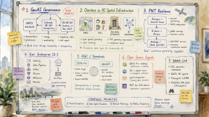
The most consequential geospatial market development this week was not a product launch. It was the convergence of regulatory, standards, and governance activity around GeoAI. NATO’s call for standards on AI-enhanced geospatial intelligence, surfaced at GEOINT 2026, Colorado’s algorithmic transparency pivot under SB 189, and the EU Digital Omnibus agreement extending AI Act compliance deadlines to December 2027 arrived in the same window. Taken together, they point to a maturing regulatory perimeter for commercial vendors selling spatial AI into defense markets, enterprise risk systems, or EU-regulated organizations.

The practical question is no longer whether GeoAI governance is coming. It is which standards and documentation practices will emerge first, and how quickly vendors can build the infrastructure needed to support them.

That policy activity landed alongside an Overture Maps repositioning that deserves separate executive attention. Two substantive posts, one on open spatial grounding for AI models and another on image-anchored POI geometry improvement through the Places Imagery Task Force, describe Overture less as a mapping dataset and more as spatial infrastructure for AI systems. This intersects with the regulatory story. As GeoAI vendors face documentation, provenance, and lineage requirements, a well-governed open dataset with clear licensing and improving geometric accuracy becomes a compliance asset, not just a convenience.

The week’s PNT resilience activity also deserves attention. Hexagon completed its acquisition of Inertial Sense, Iridium announced plans to acquire Aireon, and ArkEdge Space completed a JAXA-commissioned study on GNSS-independent LEO positioning. Assured positioning is forming into a distinct commercial market segment. The regulatory timeline for GeoAI and the investment trajectory around PNT are the two strategic threads to keep watching.

Major Market Signals

GeoAI Regulatory Pressure Becomes Concrete

Three independent governance vectors converged this week to create the clearest regulatory environment yet for commercial GeoAI vendors. NATO’s call at GEOINT 2026 for common standards on AI-enhanced geospatial intelligence could reshape expectations for model documentation, training data provenance, and confidence thresholds for vendors selling into allied defense markets. Colorado’s SB 189 pivoted from algorithmic risk management mandates to transparency disclosure requirements, narrowing immediate compliance burdens while preserving the need for documentation in spatial decision systems. The EU Digital Omnibus political agreement extended the AI Act compliance runway to December 2027, giving organizations more time while removing any remaining ambiguity that preparation is mandatory.

For executives, the practical implication is straightforward. Geospatial AI now sits inside the regulatory scope of multiple major jurisdictions at once. Vendors that treat compliance as a future planning exercise rather than an active program may find themselves disadvantaged as buyers begin asking for evidence, lineage, and governance artifacts during procurement.

Esri Delivers a Broad Enterprise Release

ArcGIS Enterprise 12.1 arrived this week with an unusually broad launch cadence. ArcGIS Velocity for Enterprise, ArcGIS Data Pipelines for Enterprise, ArcGIS Urban, ArcGIS Mission, ArcGIS AllSource 1.6, Scene Viewer, Web Editor, Business Analyst Enterprise, Maritime, Excalibur Q2, and Monitor 2026.0 all received release coverage.

The coordinated rollout indicates that Esri is closing the capability gap between its cloud and on-premises platforms. That matters for organizations with air-gapped, sovereign-cloud, or regulatory requirements that have kept them on-premises while cloud-native tooling advanced. For competitors and open-source alternatives, the argument that cloud Esri tools remain materially ahead of Enterprise becomes harder to sustain in customer evaluations.

PNT Resilience Emerges as a Commercial Market

Positioning, navigation, and timing moved this week from a defense-centered concern toward a more recognizable commercial market segment. Hexagon completed its acquisition of Inertial Sense, adding tactical-grade GNSS and inertial navigation technology to its assured PNT portfolio. Septentrio, a Hexagon subsidiary, unveiled the mosaic-G5 P8, a 2.2-gram, 23mm by 16mm multi-frequency module with AIM+ Ultimate anti-jamming and anti-spoofing technology for UAVs, marine vessels, and rail. ArkEdge Space completed a JAXA-commissioned feasibility study on a dedicated, GNSS-independent LEO-PNT satellite system. Iridium announced plans to acquire Aireon to consolidate ADS-B aviation safety positioning under its satellite network.

The convergence of contested GNSS environments, drone proliferation, and critical infrastructure protection is creating a commercial market around capabilities that were previously more tightly associated with defense procurement.

Overture Maps Positions as AI Spatial Infrastructure

Two substantive posts from the Overture Maps ecosystem point to a strategic repositioning from open map data to foundational AI infrastructure. The foundation published “Open Spatial & Location Grounding for AI,” arguing that Overture’s standardized, openly licensed dataset can serve as a spatial grounding layer for AI models and agents. Separately, the Places Imagery Task Force, a collaboration between Zephr, Mapillary, and other Overture members, announced a computer vision pipeline that anchors POI geometries to actual building entrances rather than address centroids. That work addresses placement errors that previously placed nearly half of some data samples outside any building footprint.

Sparkgeo’s related post on “self-healing” places data described the next step: continuously updating datasets that reflect real-world change rather than static snapshots. Taken together, these developments describe a dataset being made more machine-ready for AI consumption, with clearer lineage and improving accuracy. That position becomes more valuable as GeoAI documentation and provenance expectations grow.

Notable Company Activity

Product Releases

  • Esri: ArcGIS Enterprise 12.1 launched across a dozen product lines. ArcGIS Velocity for Enterprise and ArcGIS Data Pipelines are the most important additions because both were previously cloud-only capabilities and are now available to on-premises deployments.
  • Septentrio (Hexagon): The mosaic-G5 P8 is an ultra-compact, multi-frequency GNSS receiver module with tactical-grade anti-jamming and spoofing protection, targeting UAVs, marine, and rail applications in contested positioning environments.
  • MapTiler: Released a feature allowing customers to blend proprietary or custom imagery into global satellite base maps, lowering the barrier for organizations with specialized imagery collections to create publication-quality maps.

Partnerships

  • Overture Maps / Zephr / Mapillary: The Places Imagery Task Force has built a production-scale computer vision pipeline for improving POI geometric accuracy across the Overture dataset. The improvement flows downstream to all consumers of Overture data.

Funding and M&A

  • Hexagon → Inertial Sense: Acquisition completed, adding tactical-grade inertial navigation to Hexagon’s assured PNT portfolio alongside Septentrio’s GNSS hardware.
  • Iridium → Aireon: Announced acquisition to consolidate global ADS-B aircraft tracking and aviation safety services under Iridium’s satellite network.
  • Geo Owl → Quick Services LLC: Expanded full-spectrum GEOINT capabilities for the special operations and intelligence communities.

Government and Policy Developments

This was a notable week for geospatial standards activity. The OGC formally released the JSON-FG, Features and Geometries JSON, Standard, extending GeoJSON to support coordinate reference systems beyond WGS 84, geometry types beyond the original Simple Features set, and type-based feature classification. JSON-FG has been years in development. Its official release gives implementers a stable target for pipelines constrained by GeoJSON’s WGS 84 restriction, a persistent friction point in engineering and surveying applications.

openEO was also approved as a new OGC Community Standard, giving the open Earth observation processing API formal consortium backing. For the EO analytics market, openEO allows data scientists to write processing workflows that are portable across platforms and cloud providers, reducing vendor lock-in in satellite data pipelines. Two OGC standards moving in the same week is unusual and reflects a continued maturation of the standards base supporting operational geospatial systems.

On the policy side, the GeoAI and the Law Newsletter provided the most substantive synthesis of the week’s regulatory landscape, connecting NATO standards requirements, Colorado’s SB 189, and the EU Digital Omnibus. The extended December 2027 AI Act deadline gives organizations more runway, but it also makes the compliance timeline concrete enough for engineering and documentation planning.

DataMapWales reached 3,000 datasets in its national spatial data portal, a milestone for what began as a targeted environmental tool a decade ago and has grown into a comprehensive national SDI platform. The milestone illustrates the long-run trajectory of national SDI programs when they receive sustained institutional support.

Technology and Research Trends

Two themes dominated the week’s technology activity: AI-readiness in geospatial data infrastructure, and the operational maturation of large-scale airborne and satellite sensing programs.

On AI-readiness, Overture’s spatial grounding work and geoMusings contributor Bill Dollins’s post on “Prototyping AI-Ready OSM” address the same structural problem from different angles. Existing geospatial datasets were built largely for human-readable mapping interfaces, not for consumption by language models or spatial reasoning agents. Dollins’s prototype explores what OpenStreetMap restructuring might look like if the audience were AI agents rather than tile renderers.

Separately, the Open Semantic Interchange initiative introduced a YAML-based standard for sharing semantic metadata across analytics, AI, and BI platforms, with CARTO among its working group members. If adopted, OSI could improve how spatial context is communicated across enterprise data stacks, a capability that is becoming more important as spatial data moves into AI pipelines.

On large-scale sensing, a U.S. airborne hyperspectral mineral mapping program operating ER-2 aircraft at 70,000 feet has now covered more than 1 million square kilometers. That scale suggests geological and critical minerals mapping is moving from research toward operational survey. EarthDaily provided a commercially relevant case study: its satellite analysis detected U.S. winter wheat stress conditions in time to inform decision-makers before the USDA revised production estimates downward. Dense temporal EO coverage can lead official data releases, not only confirm them, creating value for commodity traders, food security analysts, and agricultural insurers.

The Geo Week News analysis of interoperability bottlenecks and an LiDAR plus AI vegetation management case study from eastern Canada both point toward the same operational reality. The technical barriers to AI-enhanced spatial analysis are falling, but data exchange standards and enterprise integration remain practical limits on deployment velocity.

Open Source Ecosystem Signals

The QGIS project announced its 2026 Grant Programme results this week, funding targeted contributions across multiple technical domains. The announcement coincided with renewed discussion, covered in the Spanish-language GIS community by MappingGIS, of the QGIS 4.x roadmap. That roadmap is expected to integrate professional 3D capabilities and digital twin support through a community crowdfunding campaign initiated by Lutra Consulting and NorthRoad in 2025.

For platform evaluators, the 3D and digital twin roadmap widens QGIS’s competitive surface area, particularly as Esri’s ArcGIS Urban and Scene Viewer investments point to the commercial market’s direction. The combination of grant programme funding and directed crowdfunding also reflects a maturing community investment model for open-source capability development.

GeoSolutions blogged from GEOINT 2026 on delivering “real impact with open source geo,” a continued indication that open-source geospatial is now an accepted presence in a conference historically dominated by proprietary and defense-oriented technology. The Geo-Jobe post on “Why MCP Matters for GIS Admins” introduced the Model Context Protocol to the ArcGIS enterprise administration audience, describing a shift from LLMs providing instructions for humans to execute toward LLMs performing direct actions on GIS systems. Whether MCP for GIS administration takes hold quickly or slowly, the framing reflects a broader movement of AI agent tooling into enterprise geospatial workflows.

The formal release of the OGC JSON-FG Standard and the openEO OGC Community Standard are also directly relevant to open-source practitioners. Both standards have significant open-source implementation communities that now have a stable specification to target.

Watch List

  • Open Semantic Interchange: A new vendor-neutral YAML-based initiative for sharing semantic metadata across analytics, AI, and BI platforms, with CARTO in the working group. Adoption could change how spatial context travels through enterprise data stacks.
  • LEO-PNT as a GNSS alternative: ArkEdge Space’s JAXA-commissioned study on a dedicated GNSS-independent LEO positioning system is one of the clearer public engineering descriptions of alternative positioning infrastructure. Multiple national programs are exploring similar territory.
  • QGIS AI agent tooling: Two community tutorial videos from Open Geospatial Solutions this week covered the QGIS NASA OPERA Plugin plus AI Agent and a QGIS Terminal Plugin. Community-built AI integrations for QGIS continue to appear ahead of any formal roadmap commitment.
  • Transgrid full-network LiDAR campaign: Australia’s major transmission operator has launched a complete airborne LiDAR scan of its network, a data investment that often precedes digital twin and AI-based asset management deployment at utility scale.
  • FOSS4G NA 2026: Workshop registration has opened. The workshop lineup will help indicate which open-source geospatial technologies are getting the most practitioner momentum this year.

Top Posts of the Week

  1. GeoAI and the Law NewsletterGeoAI and the Law Newsletter — The clearest available synthesis of the week’s GeoAI regulatory convergence across NATO standards, Colorado SB 189, and the EU Digital Omnibus.
  2. Open Spatial & Location Grounding for AIOverture Maps Foundation — Articulates Overture’s strategic positioning as foundational spatial infrastructure for AI systems rather than only a map data source.
  3. OGC Releases the Features and Geometries JSON (JSON-FG) StandardOpen Geospatial Consortium — Resolves years of uncertainty around GeoJSON’s coordinate reference system limitations, giving implementers a formal and stable standard.
  4. Hexagon Advances its PNT Roadmap with the Acquisition of Inertial SenseGeo Week News — Indicates that assured PNT is a strategic portfolio priority for major geospatial hardware vendors, not only defense contractors.
  5. QGIS 4 revoluciona los SIG: llegan los gemelos digitales y el 3D profesionalMappingGIS — Documents the QGIS 4.x roadmap for professional 3D and digital twin integration, widening open-source competition with commercial platforms.

Cercana Executive Briefing is generated from 161 feeds aggregated by geofeeds.me.