
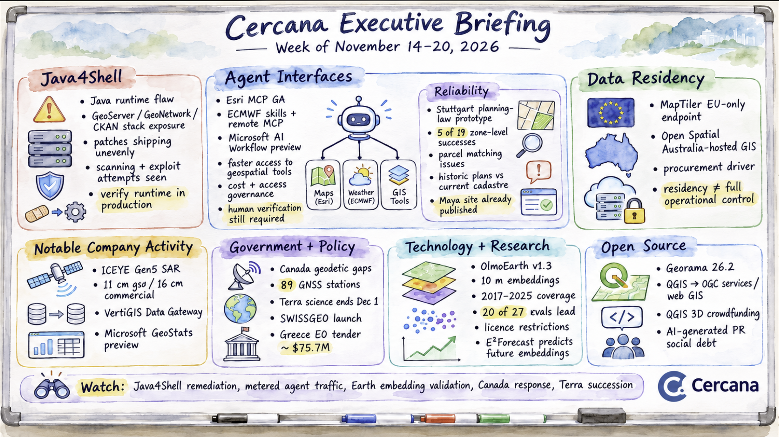
Executive Summary
Java4Shell, disclosed November 17, exposed a vulnerability in certain Java runtimes supporting GeoServer, GeoNetwork, CKAN’s Solr, and related software. Patches are available, but updated containers and application packages are arriving unevenly. Security firms have reported scanning and attempted exploitation, although no successful compromises were confirmed in the cited reports through November 19.
Geospatial agent interfaces moved closer to routine deployment. Esri released MCP for ArcGIS Location Services, ECMWF published skills and a remote MCP server, and Microsoft previewed automated model inference. A Stuttgart planning-law experiment and a disputed Maya archaeological discovery highlighted continuing problems with source reconciliation and verification.
MapTiler and Open Spatial introduced EU and Australian hosting options, respectively, reflecting procurement interest in data residency. Their announcements leave questions about administrative control and the scope of residency guarantees.
For buyers and operators, the week’s developments raise questions about implementation, such as verifying runtime fixes, governing agent access and costs, and establishing what hosting arrangements guarantee.
Major Market Signals
Java4Shell exposes geospatial infrastructure dependencies
Security firm Calif disclosed Java4Shell (CVE-2026-114938) on November 17. The vulnerability affects the hardware-accelerated Base64 decoder in certain Java runtimes on x86-64 hardware supporting AVX-512 VBMI. GeoServer, MapStore, GeoNetwork, and Java components supporting GeoNode and CKAN may be exposed, depending on their runtime configurations.
Researchers demonstrated exploitation against several enterprise Java applications. By November 19, security firms had observed scanning and exploitation attempts, although no successful intrusions had been confirmed in those reports. An attack path through GeoServer itself has not been demonstrated.
Oracle, Amazon Corretto, Azul, and Eclipse Temurin have released fixes, but updated container images and application packages are arriving on different schedules. GeoSolutions has published product-specific remediation guidance, including an interim JVM mitigation.
The immediate concern is identifying affected deployments and confirming that patched runtimes are actually running in production. Organizations using community-maintained containers face additional dependencies on upstream maintainers. Even where application code is unaffected, vulnerabilities in its supporting infrastructure can create operational exposure.
Geospatial agent interfaces expand, while verification remains uneven
Esri released MCP for ArcGIS Location Services to general availability on November 19, supporting geocoding, routing, enrichment, mapping, and elevation. ECMWF published agent skills and a remote MCP server for weather and climate resources. Microsoft opened a private preview of AI Workflow within Planetary Computer Pro, allowing agents to orchestrate geospatial model inference.
The releases differ in maturity, but each makes existing geospatial capabilities more accessible to AI agents. Esri applies standard consumption pricing to MCP calls, potentially complicating cost management when agents invoke multiple services. Safe Software emphasized that MCP leaves access controls to implementers, recommending narrowly scoped tools and role-specific permissions.
Two experiments illustrated the limits of agent reliability. An OGC-published Stuttgart planning-law prototype demonstrated rapid responses to regulatory questions but encountered difficulty reconciling historic planning documents with current cadastral records. Across 19 test questions, its text and vision components correctly answered five zone-level questions, while the remaining 14 were declined or stopped early. A separate cadastral component frequently selected incorrect parcels or failed to produce an answer. The full system remains incomplete.
Separately, a project using 48 agents to analyze NASA lidar initially reported an undiscovered Maya archaeological site, then acknowledged that the site had already been documented in a 2025 publication.
Geospatial agents are gaining access to more services and analytical capabilities. Their practical reliability still depends on source selection, evidence reconciliation, permission boundaries, and independent verification.
Data residency becomes a competitive feature for mapping platforms
MapTiler introduced an EU-only API endpoint on November 19, keeping end-user tile, geocoding, and terrain requests, including associated IP addresses, within EU infrastructure. Open Spatial launched a managed GIS platform in Australia, built on PostGIS, GeoServer, and QGIS, with customer data and backups hosted onshore.
Both offerings target organizations facing jurisdictional procurement requirements. They also provide smaller vendors with a means of differentiating their services from globally distributed platforms.
The guarantees have limits. MapTiler’s commitment covers end-user requests but does not specify the processing location of management operations or identify its infrastructure provider. Open Spatial provides limited information about administrative access and customer control over its hosting environment.
Organizations evaluating these services will need to distinguish data residency from operational control. The location of stored or processed data addresses only part of the governance and compliance requirements that can influence procurement.
Notable Company Activity
ICEYE announced its Gen5 SAR satellite on November 16. The advertised 11 cm resolution is available to government customers using 1,800 MHz of bandwidth, subject to ITU rules. Commercial customers receive up to 16 cm resolution, matching Gen4’s stated best-case performance. For commercial buyers, the improvements center on capacity and onboard processing. A launch date was not specified.
VertiGIS announced Data Gateway on November 18, its first major platform innovation following the April 2026 acquisition of 1Spatial. The offering combines data validation, transformation, and governance capabilities with support for cloud, customer-managed, and on-premises deployments. The announcement provides no pricing or customer deployment figures.
Microsoft opened a GeoStats preview within Planetary Computer Pro. The feature computes raster statistics across customer-defined geometries and publishes results as tables in GeoCatalog. Microsoft used agricultural lending to illustrate how raster observations could be incorporated into operational risk analysis.
Government and Policy Developments
A Council of Canadian Academies expert panel reported gaps in Canada’s geodetic infrastructure on November 19. Canada operates ground stations supporting only two of the four core geodetic techniques and has no co-located core site. Its network includes 89 continuously operating GNSS stations, approximately one per 112,000 km², compared with roughly one per 38,000 km² in Australia. The panel identified three opportunities for improvement, including dedicated low-Earth-orbit positioning satellites. Natural Resources Canada commissioned the report, but no funding has been committed, and the panel conducted no cost-benefit analysis.
NASA’s Terra satellite will end science observations on December 1, concluding nearly 27 years of operations. The historical archive will remain accessible. Organizations relying on continuing MODIS or ASTER observations from Terra will need to evaluate replacement sources and continuity of derived products.
Switzerland officially launched SWISSGEO on November 17, a joint federal and cantonal geoplatform designed to consolidate access to five existing geoinformation services. The initial release supports searching, exploring, visualizing, and combining geodata. Other capabilities and services will be integrated gradually.
Greece opened an approximately $75.7 million tender through ESA for three optical Earth observation satellites offering resolution up to 30 cm. Bids are due December 23.
Technology and Research Trends
The Allen Institute for AI’s OlmoEarth v1.3 provides global 10 m embeddings hosted on Source Cooperative, representing approximately 150 TB per year. The dataset now has complete annual coverage from 2017 through 2025.
Ai2 reports that its 128-dimensional embeddings outperformed AlphaEarth Foundations and TESSERA v2 in 20 of 27 evaluations, while the 64-dimensional version led in 18. Training v1.3 required 18% of the compute used by the original OlmoEarth v1 model. These are developer-reported results that await independent replication.
Precomputed embeddings allow users to train lightweight classifiers without repeatedly processing source imagery through a foundation model. Provenance tables link the embeddings to their underlying Sentinel-1, Sentinel-2, and Landsat observations, providing a means of tracing analytical inputs.
The OlmoEarth Artifact License restricts military and defence-related applications, intelligence gathering, surveillance, and extractive activities, including oil, gas, and mineral extraction. These restrictions apply to specified uses and extend to derivative works. Organizations evaluating OlmoEarth will need to consider both its technical performance and licensing conditions.
A separate preprint, E²Forecast, explores predicting future embeddings from historical sequences. Its authors report approximately halving forecast error across nine embedding spaces. The technique remains at the research stage.
Open Source Ecosystem Signals
OPENGIS.ch released Georama 26.2, enabling QGIS projects to be published as OGC services or complete web GIS applications. The product is available under AGPL or a commercial licence.
Lutra Consulting is crowdfunding additional QGIS 3D development. Several capabilities within the widely used desktop GIS continue to depend on community contributions and targeted funding campaigns.
Brianna Corremonte of Development Seed examined the growing burden of AI-generated contributions on open-source maintainers. She described the accumulation of “social debt” as maintainers contend with low-quality pull requests while newcomers have fewer opportunities to develop expertise through meaningful participation. Her account is qualitative, but the costs she describes would be difficult to detect through conventional measures such as release frequency or the number of accepted contributions.
Watch List
- Java4Shell remediation: Delays in updating deployed container images or evidence of successful exploitation would increase concern about operational exposure.
- Metered agent traffic: Unexpected customer costs or agent-specific pricing and rate limits would indicate whether current consumption models need adjustment.
- Independent evaluation of Earth embeddings: Third-party replication of OlmoEarth’s benchmark results and evidence of adoption under its licence will clarify its competitive position.
- Canada’s geodetic infrastructure response: Federal funding, named sites, or station expansion commitments would indicate movement from recommendations to implementation.
- Terra succession: NASA’s replacement-product guidance and operational reports following December 1 will help establish whether Terra’s retirement creates data continuity problems.
Top Posts of the Week
- Java4Shell (CVE-2026-114938): what to do for GeoServer, MapStore, GeoNode, GeoNetwork and CKAN – GeoSolutions – November 18, 2026 – Product-specific remediation guidance identifying affected Java dependencies, tested and untested measures, and available mitigations.
- What’s New in ArcGIS Location Platform? Developer Tools for Agentic Workflows and More – ArcGIS Blog – November 19, 2026 – Esri’s announcement of general availability for MCP access to location services, including supported capabilities and pricing.
- Connecting Cadastral Data and Building Regulations: Lessons from an AI Prototype in Stuttgart – Open Geospatial Consortium – November 17, 2026 – An account of an AI-assisted planning prototype, its test results, and problems reconciling cadastral and regulatory records.
- 🌐 Wildfire risk to US buildings could nearly triple by 2060 – The Spatial Edge – November 18, 2026 – Research roundup covering OlmoEarth v1.3, embedding forecasts, licensing restrictions, and the corrected Maya lidar discovery.
- CCA Report Finds Major Gaps in Canada’s Geodetic Infrastructure – GoGeomatics – November 19, 2026 – Summary of the expert panel’s findings, international comparisons of station density, and recommendations for Canadian geodetic infrastructure.