
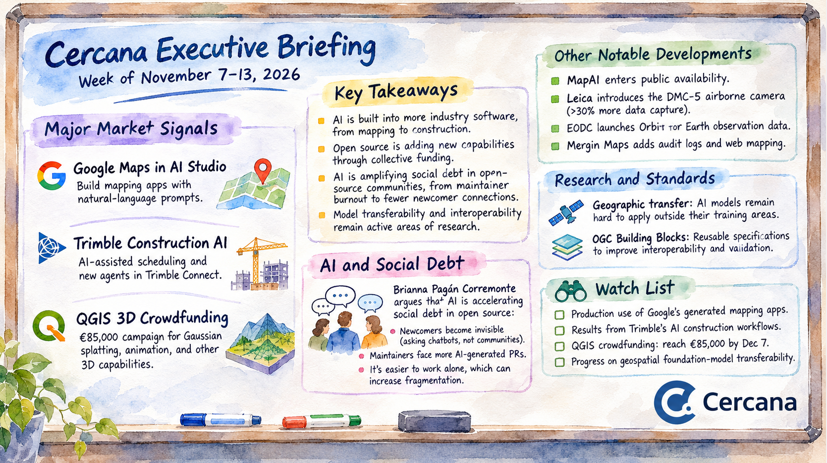
November 13, 2026
Executive Summary
Google and Trimble provided two of the week’s clearest examples of AI finding its way into established industry software. Google integrated Maps Platform into AI Studio, allowing developers to create mapping applications using natural-language prompts. Trimble introduced AI-assisted construction scheduling and expanded its Connect platform with capabilities that draw on project data and operational workflows. Both could change how organizations build and use specialized applications, though their reliability in production remains to be demonstrated.
The open-source community took a different approach to platform development. Lutra Consulting and North Road launched an €85,000 crowdfunding campaign to bring Gaussian splatting, improved animation, and other 3D capabilities into QGIS. The campaign shows how organizations can collectively finance development in shared software infrastructure. Meanwhile, Development Seed’s Brianna Pagán Corremonte examined how AI is amplifying longstanding social problems in open-source communities, from maintainer burnout to the erosion of relationships through which new contributors become involved. Together, these stories raise questions about how open-source projects fund new capabilities while sustaining the people who maintain them.
Research into the geographic transferability of Earth observation models highlighted the difficulty of applying AI systems outside their training environments. OGC’s work on reusable data specifications addressed related challenges involving interoperability and machine-readable validation.
Running through these developments is a question about the economics of software development. AI may substantially reduce the effort required to create applications and automate workflows. Whether it reduces the total cost of operating those systems is less certain. Some of the savings may be offset by additional work in integration, validation, governance, and maintenance.
Major Market Signals
Google Brings Geospatial Application Development into AI Studio
On November 9, Google announced that developers can use Google Maps Platform directly within Google AI Studio. Developers can describe an application in natural language and have AI Studio configure mapping services and generate an interactive application. Supported capabilities include maps, places, routing, 3D visualization, and environmental information.
The integration also simplifies access to Maps Platform credentials. Google provides introductory access without requiring a credit card, subject to daily quotas. Production use still requires a paid Google Cloud billing account.
This could substantially reduce the effort required to produce a functioning location-based application. A developer or business analyst could move from an idea to an interactive prototype without first assembling the usual application framework, service configuration, and mapping components.
Businesses with relatively straightforward geographic requirements stand to benefit first. Store locators, service-area applications, routing tools, and location-based customer interfaces are plausible early uses.
The development also raises questions for firms whose products simplify conventional mapping application development. If a major platform provider can generate much of that functionality through a conversational interface, vendors may find themselves competing more on specialized data, analytical methods, operational integration, and domain expertise.
Easier development could also expand the market for specialized geospatial services. Organizations that previously lacked the resources to build location-based applications may begin experimenting with geographic capabilities, creating additional demand for data integration, spatial analysis, and production engineering.
Both outcomes remain plausible. AI Studio simplifies application creation within Google’s ecosystem, but generated applications still need to meet enterprise requirements for security, maintainability, interoperability, and complex spatial analysis.
Production deployments will provide a clearer picture of how much development effort these tools eliminate, how well generated applications hold up as requirements change, and where specialized expertise remains necessary.
Source: Google Developers Blog, November 9, 2026.
Trimble Connects Industry-Specific AI with Operational Construction Data
Trimble used its November 9 Dimensions conference announcements to introduce new AI capabilities across its construction technology portfolio.
Among them was Trimble Connect Scheduling, an AI-assisted scheduling system that connects project timelines with information such as requests for information, weather, field reports, and construction activities. It can identify potential scheduling conflicts and recommend adjustments for review by project teams.
Trimble also announced broader AI capabilities within Trimble Connect, including Trimble Assist and an Agent Studio for developing customized agents. The company described these additions as part of a platform connecting design, construction, and operational workflows.
Trimble is incorporating AI into systems that already contain relevant data, business rules, and operational context. That offers a different starting point from building a general-purpose AI application and connecting it to enterprise systems afterward.
Construction scheduling is a demanding application. A schedule depends on equipment availability, labor, subcontractors, weather, materials, design changes, and other variables that rarely remain static. Giving an AI system access to these information sources could help project teams identify problems earlier.
The operational integration may prove more significant than the AI interface itself. Access to project context, established workflows, and existing user relationships gives incumbent vendors advantages that general-purpose AI applications may struggle to replicate. Of course, the automation will only be as effective as the project information available to it.
Trimble’s announcements also suggest that established industry vendors see opportunities to extend their platforms with configurable agents. That could strengthen their position among existing customers by reducing integration work.
The available performance evidence remains largely vendor-supplied, including accounts from contractors involved in developing the scheduling system. The announcements establish product direction and early industry participation. Independently measured cost savings and consistent performance across projects remain less clear.
Buyers face a familiar tradeoff. Integrated, industry-specific capabilities may be easier to deploy and operate, but expanding an existing vendor platform can bring additional costs and dependencies. How well these systems work with external data and independently developed tools will influence that balance.
Sources: Trimble, November 9, 2026; Earth Imaging Journal, November 10, 2026.
QGIS Crowdfunding Targets Reality Capture and Advanced 3D Visualization
On November 11, Lutra Consulting and North Road publicized a crowdfunding campaign to extend QGIS’s three-dimensional capabilities.
The campaign seeks €85,000 by December 7, 2026. Its objectives include support for 3D Gaussian splatting through 3D Tiles, an improved animation framework for two-dimensional and three-dimensional views, atmospheric rendering, and refinements to navigation and scene presentation.
If funded, the developers intend to deliver the capabilities across QGIS releases during 2027, including versions 4.6, 4.8, and 4.10. These are proposed development targets, rather than features already available.
Gaussian splatting has attracted interest as a way to represent detailed three-dimensional scenes derived from imagery. Integrating it into QGIS would allow reality-capture content to be viewed alongside conventional geographic layers and analytical information.
That combination could support engineering, infrastructure management, digital twins, environmental analysis, and other applications requiring detailed representations of physical environments.
The funding model is also significant. Organizations that need these capabilities can contribute toward implementation in shared open-source software rather than waiting for a commercial platform vendor to prioritize them.
This provides a potential route for specialized capabilities to become broadly available while preserving interoperability and reducing dependence on proprietary applications.
The campaign must first meet its funding target, and planned delivery dates don’t guarantee that the resulting features will satisfy every operational requirement.
There is a broader question here about how open-source geospatial development is financed. Organizations with specialized requirements may find that contributing to shared infrastructure makes more sense than paying for separate implementations, particularly when the resulting capabilities can be maintained and improved by a wider community.
Source: North Road, November 11, 2026.
Notable Company Activity
MapAI enters commercial availability. Australia’s MapAI mapping platform became available to individual and corporate users following several years of development. Its natural-language interface adds another AI-assisted mapping option to the market, though adoption and operational performance remain to be demonstrated. Spatial Source, November 10.
Leica introduces the DMC-5 airborne camera. Leica Geosystems announced a large-format mapping camera built on its MFC250 platform. The company claims more than 30% additional data capture compared with previous generations, potentially improving the economics of large-area aerial surveys. GeoConnexion, November 10.
EODC introduces Orbit. The Earth Observation Data Centre introduced Orbit as a replacement for its existing portal for discovering and accessing Earth observation data. The new interface is intended to make imagery collections easier to find and use. EODC, November 10.
Mergin Maps expands enterprise administration. Enterprise Edition 2026.10.1 introduced audit logs and web mapping capabilities. The addition of audit records addresses traceability requirements in field-data collection and editing workflows. Mergin Maps, November 10.
Technology and Research Trends
Geographic Transfer Remains a Difficult Test for AI Models
Two master’s thesis defenses reported on November 12 by the University of Würzburg’s Earth Observation Research Cluster examined the application of AI models across different geographic environments.
Christina Krause explored adapting visual foundation-model features for building classification relevant to seismic risk, using imagery from Santiago and Lima. Marlene Bauer examined informal-settlement detection across 12 cities in Africa, Asia, and Latin America, including assessments of uncertainty when models were applied to cities excluded from training.
The work addresses a persistent challenge for geospatial AI: patterns learned in one geographic setting may not transfer reliably to another. Differences in building materials, settlement structure, environmental conditions, image characteristics, and training data can all affect model performance.
Researchers generally approach this problem in two ways. One is to develop models that perform reliably across environments without additional local training. The other is to adapt a model using information from the target environment. Adaptation can improve performance where local conditions differ from the original training data, but it also creates requirements for representative examples, validation, and continued maintenance.
These studies explore methods for managing geographic variation and uncertainty. As individual student research projects, they don’t establish general solutions or demonstrate how the approaches perform at operational scale.
For organizations deploying geospatial foundation models, the distinction matters. A model that performs consistently across regions may support a common analytical workflow. One that requires substantial local adaptation could introduce additional data acquisition, labeling, and quality-assurance costs every time it moves to a new geography.
Performance against a familiar benchmark may therefore provide little assurance of results elsewhere. Geographic validation, uncertainty estimates, and suitable local reference data remain necessary to establish where a model can be used reliably.
Sources: Krause’s thesis defense and Bauer’s thesis defense, November 12, 2026.
OGC Advances Reusable Specifications for Cultural Heritage Data
The Open Geospatial Consortium published an explanation of how modular Building Blocks can improve interoperability among cultural heritage information systems.
The approach uses reusable specifications to describe assets, surveys, spatial relationships, digital models, and supporting documentation. Individual components can incorporate schemas, semantic definitions, and validation rules, allowing software to interpret and check information from different institutions.
The example concerns cultural heritage, but the approach could apply to many other spatial information systems.
It also has implications for AI-based analytical applications. Structured data descriptions and machine-readable validation rules can help establish what information represents, whether it meets requirements, and how it relates to other records.
Human judgment and analytical validation are still required, but these specifications can reduce ambiguity when information moves between systems.
Source: Open Geospatial Consortium, November 11, 2026.
AI Accelerates the Social Debt of Open Source
In a November 9 essay for Development Seed, Brianna Pagán Corremonte argues that AI is accelerating the social debt open-source communities have accumulated over decades. Drawing on her closing keynote at FOSS4G North America, she describes how longstanding problems involving burnout, unequal participation, and dependence on individual contributors are becoming more pronounced as AI changes software development.
Corremonte identifies three mechanisms. New contributors increasingly turn to chatbots rather than asking questions in public forums, removing opportunities to build relationships with project communities. Maintainers face growing volumes of AI-generated contributions that still require human review. Meanwhile, the ease of generating software independently may encourage developers to create isolated tools rather than contribute to existing projects.
These pressures affect more than community participation. Open-source projects depend on people who review code, maintain documentation, mentor contributors, coordinate decisions, and preserve institutional knowledge. Much of this work is informal, frequently unrecognized, and unevenly distributed. When it goes unsupported, the consequences can eventually appear in software quality, project continuity, and governance.
Corremonte points to Openscapes and GeoJupyter as examples of communities deliberately investing in collaboration and inclusion. Her argument is that sustaining open source requires treating these activities with the same planning and attention given to technical maintenance.
The implications extend to organizations that depend on open-source infrastructure. The QGIS crowdfunding campaign illustrates how users can collectively finance new capabilities. Corremonte’s essay highlights a complementary requirement: the people and relationships needed to develop, maintain, and govern those capabilities over time. As AI makes producing software easier, sustaining the communities behind shared software may become more difficult.
Source: Brianna Pagán Corremonte, Development Seed, November 9, 2026.
Watch List
- Google’s generated mapping applications: Whether organizations move from rapid prototypes to maintainable production systems, and what that transition requires in developer effort, governance, and billing.
- Trimble’s AI-assisted construction workflows: Whether customer deployments demonstrate measurable improvements in schedule adherence, delay prediction, and project coordination.
- QGIS 3D crowdfunding: Whether the campaign reaches its €85,000 target by December 7 and how the planned features progress through the 2027 release schedule.
- Geospatial foundation-model transferability: Whether research on geographic generalization and uncertainty produces repeatable results across independent datasets and operational use cases.
Top Posts of the Week
- From Prompt to App: Build with Google Maps in AI Studio – Google Developers Blog – November 9, 2026 – Explains Google’s integration of mapping APIs and application generation within AI Studio, including the development experience and access arrangements.
- Trimble Launches New AI-Accelerated Scheduling Solution – Trimble – November 9, 2026 – Describes the company’s integration of project data and AI-assisted scheduling, providing an example of domain-specific automation within an established industry platform.
- Our Next QGIS 3D Crowdfunder with Lutra Consulting – North Road – November 11, 2026 – Outlines the funding campaign, proposed capabilities, and delivery expectations for QGIS reality-capture and animation enhancements.
- AI is Accelerating our Social Debt – Development Seed – November 9, 2026 – Brianna Pagán Corremonte examines how AI is amplifying longstanding strains on open-source communities, including maintainer burnout, invisible newcomers, and the fragmentation of collaborative development.
- What Are Building Blocks, and Why Are They Useful for Cultural Heritage? – Open Geospatial Consortium – November 11, 2026 – Explains how reusable, machine-interpretable data specifications can support interoperability and validation across institutions.
Subscribe to the Cercana Executive Briefing by email for weekly analysis of geospatial technology, AI, and related technology markets.