
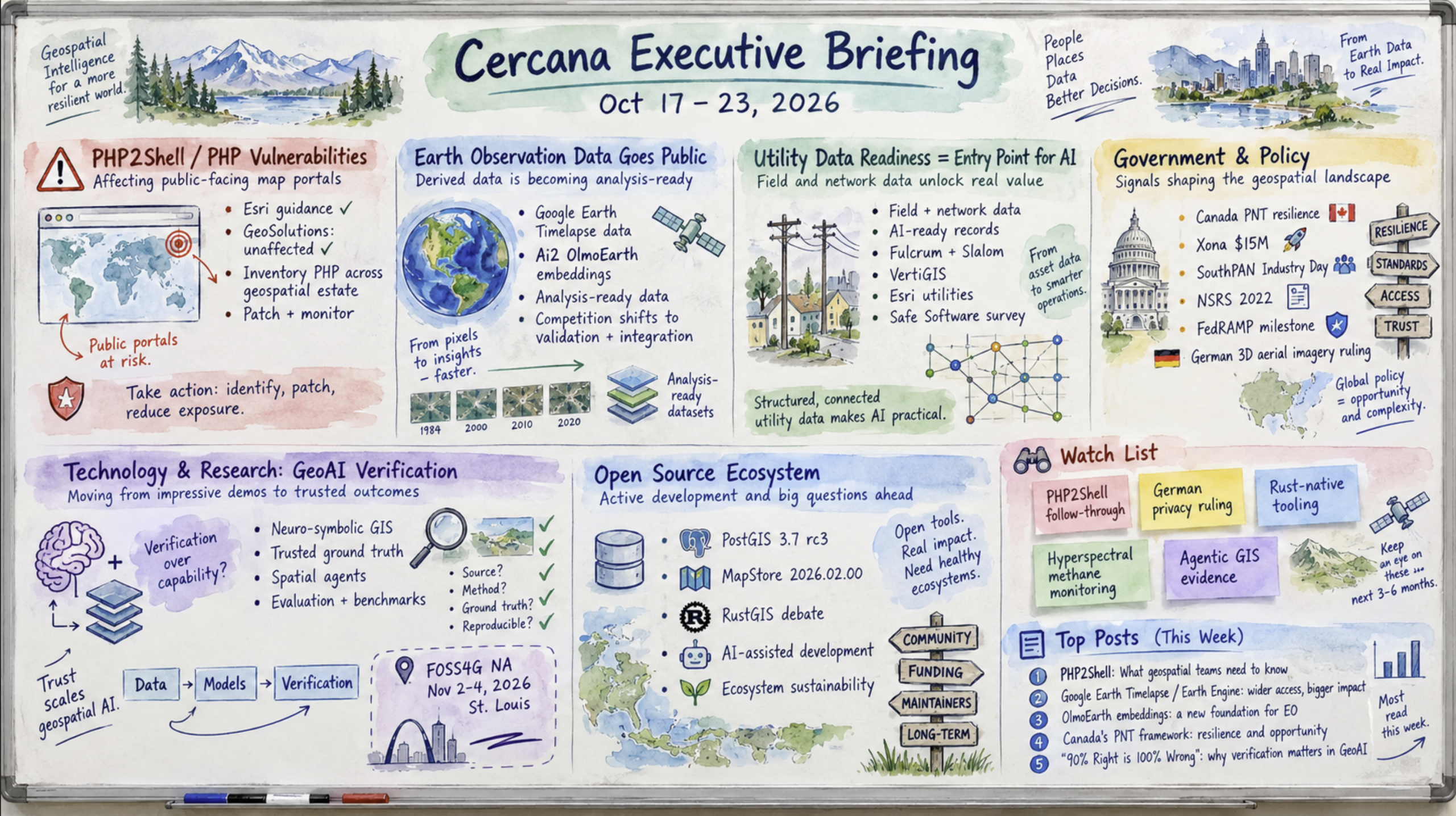
168 feeds monitored. Published October 23, 2026.
This week’s briefing again includes the story map format. Scroll past the map to read the full text of the briefing.
Executive Summary
168 feeds monitored; 139 returned content. Published October 23, 2026.
This week brought no transactions or contract awards that appear to change the structure of the geospatial market. The most immediate issue was operational. PHP2Shell, two critical PHP vulnerabilities disclosed on October 21, prompted guidance from Esri and GeoSolutions. Organizations operating public-facing map portals may have PHP components outside the GIS team’s inventory, making a broader exposure review worthwhile.
A quieter development came from Earth observation. Ai2 and Google released derived, analysis-ready datasets for public use, and Google published its methodology. If such releases continue, they could put pressure on commodity derived-data products and shift more of the competitive value toward validation, domain integration and service. Several vendors also framed utility data readiness as a prerequisite for AI programs, although utilities are an established GIS market and the concentration of announcements may be coincidental.
AI reliability also figured prominently in practitioner commentary. Several authors argued that verification, rather than model capability alone, is limiting GeoAI. The argument is coherent, but it is not yet evidence of buyer behavior. Other developments to follow include any confirmed PHP2Shell exposure among geospatial vendors, the appeal of a German ruling concerning Google’s 3D aerial imagery, and whether agent demonstrations at FOSS4G North America (November 2–4) include evidence from production deployments.
PHP2Shell and geospatial vendor exposure
According to GeoSolutions, the PHP project released fixes on October 21 for two critical vulnerabilities allowing unauthenticated remote code execution (CVE-2026-109618 and CVE-2026-109619). Exploitation attempts reportedly began before disclosure, and the UK NCSC urged organizations to patch PHP installations or take them offline. Esri published a “Recent PHP Vulnerabilities” advisory through its Trust ArcGIS program that day. GeoSolutions followed on October 23, stating that MapStore, GeoServer and GeoNode do not use PHP and are unaffected.
These are two vendor responses to one underlying event. The potential exposure for geospatial organizations may lie alongside GIS products rather than within them, including content-management systems, data portals, dashboards and utility scripts. The advisories could simply reflect routine customer support rather than actual exposure. Either way, an inventory of PHP across public-facing geospatial services is a reasonable operational response. The next meaningful evidence would be a vendor identifying an affected component or a reported compromise of a public-sector map portal.
Analysis-ready Earth-observation data
Google added the annual global mosaics behind Earth Timelapse (1984–2022) to the Earth Engine Data Catalog under CC BY 4.0 and published its methodology. Separately, Ai2 released OlmoEarth v1.3 on October 22, distributing precomputed 10-meter satellite embeddings through Source Cooperative. In a geoMusings walkthrough, Bill Dollins demonstrated how ordinary Python tooling can be used to explore the embeddings because “the expensive work of generating the representations has already happened.”
The releases come from different organizations but follow a similar pattern: compute-intensive derived products are being distributed as reusable data rather than solely through viewers or services. Both could reflect the priorities of research or outreach organizations rather than a commercial strategy. Their availability nevertheless establishes a higher free baseline for some mosaics, change products and embeddings. Commercial providers may need to compete more on currency, validation, licensing certainty and workflow integration. Price changes, new open tiers or another major producer making comparable data available would strengthen this signal. Limited downstream use would weaken it.
Utility data readiness and AI
Four vendors published utility-related announcements this week. Fulcrum and Slalom announced a partnership to use field-operations data from electric, gas and water utilities in AI programs. VertiGIS reported a deployment of VertiGIS Studio and Networks for Houston Public Works. Esri updated its Communications Utility Network Foundation and released an Electric Joint Use Permitting solution. Safe Software cited a survey, with an undisclosed sample size, in which 77% of utility respondents identified data quality and standardization as their main challenge, compared with 22% who identified legacy infrastructure.
The common message is that clean field and network data should come before AI and modernization initiatives. Utilities, however, have long been a substantial GIS market, and four announcements in one week may reflect normal activity rather than a change in demand. Only the VertiGIS item documents a deployment. Evidence of AI projects financed through data-remediation budgets, or procurement requirements for AI-ready field records, would make the pattern more persuasive.
Trimble expands entry-level grade control
Trimble released a lower-cost Earthworks grade-control configuration for excavators using dual DA2 GNSS receivers, targeting the entry-level market.
EarthDaily expands insurance application
EarthDaily added its Burn Severity and Perimeter Data product to an existing relationship with a major Australian insurer for post-catastrophe claims triage. EarthDaily described it as the first product built by the company for that account.
SynMax expands EarthDaily imagery subscription
SynMax expanded an existing EarthDaily Constellation imagery subscription for its Hyperion oil-and-gas intelligence platform serving financial markets. Together with the insurer announcement, this represents activity in two verticals for EarthDaily, not evidence of a wider market trend.
Xona funding and positioning resilience
Canada announced $15 million in backing for Xona Space Systems, a low-Earth-orbit positioning company, alongside its PNT Resilience Framework. The source does not specify the currency or whether the funding takes the form of a grant, contract or equity investment. No geospatial acquisitions or private funding rounds appeared in this week’s monitored feeds.
Positioning infrastructure across three jurisdictions
Positioning infrastructure appeared in announcements from three jurisdictions, although the developments are not directly comparable. Canada’s PNT Resilience Framework, announced at SpaceBound 2026 on October 20, includes a commitment to expand sovereign geodetic infrastructure. It is a policy commitment with an accompanying investment, not yet evidence of a funded build-out. Australia scheduled a SouthPAN Industry Day for November 10 to help firms develop products around the augmentation system. In the United States, Esri published guidance on preparing for the long-running NSRS 2022 datum modernization. Canada’s framework is the only new policy instrument among the three. Strategic Geospatial’s “So mid, so sovereign” also offered a practical test of vendor sovereignty claims: “Compute alongside Storage == Sovereignty.”
FedRAMP milestone and SBA analysis
In U.S. procurement, Trimble for Government reached FedRAMP “Initial Implementation” status for Class C (Moderate). This is a milestone in the authorization process, not a final authorization. Cercana Systems, the publisher of this briefing, also examined proposed SBA size-standard changes and their potential alignment with growth in the geospatial market. That assessment is industry analysis, not a policy action.
German ruling on 3D aerial imagery
On the legal front, #geoObserver reported that the Frankfurt Regional Court (Az. 2-03 O 388/25) ruled in favor of a homeowner who objected to Google’s 3D aerial depiction of his property. The decision is not final, and Google has said it will appeal. If upheld, it could extend privacy restrictions associated with Street View to aerial 3D content in Germany.
Local government data and Overture GERS
The 2026 TIGER/Line shapefile release was incremental. Overture’s case study involving the City of Vancouver, Esri Canada and Fresno County was more notable. The two local governments contributed authoritative data and received GERS identifiers, illustrating one way public agencies can participate in a shared global reference system. Two examples, however, do not establish broad adoption.
Verification as a GeoAI constraint
Verification was a recurring theme in GeoAI commentary this week. Sparkgeo argued that AI assistants answer spatial questions “immediately, confidently, and… often wrong.” Bill Dollins examined neuro-symbolic approaches that combine model-based interpretation with explicit GIS rules, including coordinate reference systems and topological predicates. David G. Smith responded directly to that argument, so his post should not be treated as independent confirmation. EarthDaily discussed the lack of trusted ground truth as a constraint on agricultural AI. Some of these contributors sell data-quality or measurement services, which gives them a commercial interest in the argument. Taken together, the posts show sustained attention to the ability to check AI outputs, but they do not establish that verification has overtaken capability as a purchasing constraint.
Geospatial reasoning agents and research
On the capability side, Smith summarized a Google Research Earth AI technical report describing geospatial reasoning agents that plan tasks, select tools and analyze planetary-scale data. The FOSS4G North America agenda (November 2–4) includes sessions on MCP servers, spatial agents, embeddings and DGGS-based agent workflows. The agenda shows practitioner interest, not production adoption.
Among research items, The Spatial Edge reported on a Nature Communications study finding that roughly one-third of mining land overlaps conservation priorities.
PostGIS, MapStore, and institutional contributors
Release activity was steady. PostGIS 3.7.0rc3 shipped with testing against PostgreSQL 19 RC1 and GEOS 3.15, suggesting alignment with the PostgreSQL 19 release cycle. GeoSolutions released MapStore 2026.02.00 with improvements to data-source integration, catalogs and projections. It credited contributions from the Municipality of Genoa, TotalEnergies, KfW, Deutsche Bahn and others. That contributor list offers a more useful indication of institutional support than the release announcement alone.
RustGIS and the economics of new GIS software
The RustGIS discussion, covered by Project Geospatial, raised a broader question about software development costs. Qiusheng Wu’s free, open-source GIS written in Rust prompted debate about AI-assisted development, interface design and the need for another desktop GIS in an ecosystem anchored by QGIS and GDAL. If AI reduces the cost of developing GIS applications, fragmentation may become more likely. A separate video featured terrio, a pure-Rust toolkit modeled on GDAL, but its independence from RustGIS could not be confirmed. It should not be counted as a second independent example. Other community activity, including Mapping USA 2027’s call for proposals and GDAL’s 28th anniversary, offers little insight into maintainer concentration and funding, which remain structural concerns.
Watch List: evidence to follow
PHP2Shell follow-through: Vendor exposure statements have not yet established affected geospatial products. A confirmed vulnerable component or a reported public-sector portal compromise would materially change the assessment. If no incidents emerge in the next two to three weeks, the item may warrant removal.
German aerial-imagery privacy ruling: The first-instance decision is subject to appeal. An upheld ruling or similar cases would increase its significance for 3D and oblique-imagery products in the EU. An overturned ruling would weaken it.
Rust-native geospatial tooling: So far the evidence consists of one debated project and a possibly related toolkit. A second independent release or inclusion in a major distribution would support a broader ecosystem signal. A lack of uptake would weaken it.
Hyperspectral methane monitoring: Planet launched Tanager-2 on Transporter-18, according to The Spatial Edge, and Earthworks reported more than 160 under-reported emissions events in the Permian Basin. The detection method was not specified. Regulatory enforcement or commercial contracts citing satellite detections would provide stronger evidence of market impact.
Agentic GIS at FOSS4G North America: Production deployments with measured accuracy would carry more weight than demonstrations alone.
Top Posts of the Week
1. PHP2Shell: what it means for MapStore, GeoServer and GeoNode users (GeoSolutions): A primary account of the vulnerabilities, the NCSC alert and GeoSolutions’ exposure position.
https://www.geosolutionsgroup.com/news/php2shell-what-it-means-for-mapstore-geoserver-and-geonode-users/
2. Four decades of planetary change, now open for everyone to build on (Google Earth and Earth Engine): The source for the CC BY 4.0 Timelapse release and published methodology.
https://medium.com/google-earth/four-decades-of-planetary-change-now-open-for-everyone-to-build-on-9b32d6cb8c86?source=rss—-a747a9e16c1c—4
3. Exploring OlmoEarth Embeddings (geoMusings by Bill Dollins): A hands-on look at precomputed Earth-observation embeddings using Python tooling.
https://blog.geomusings.com/2026/10/22/exploring-olmoearth-embeddings/
4. Canada puts geodesy in its PNT resilience plan, backs Xona with $15 million (GoGeomatics): Coverage of Canada’s newly announced positioning-infrastructure policy.
https://gogeomatics.ca/canada-pnt-framework-geodesy-xona-investment/
5. 90% Right is 100% Wrong (Sparkgeo): An argument for verifiability in GeoAI workflows.
https://sparkgeo.com/blog/90-right-is-100-wrong/
Cercana Executive Briefing is generated from 168 feeds aggregated by geofeeds.me. https://geofeeds.me
Executive Summary
This week brought no transactions or contract awards that appear to change the structure of the geospatial market. The most immediate issue was operational. PHP2Shell, two critical PHP vulnerabilities disclosed on October 21, prompted guidance from Esri and GeoSolutions. Organizations operating public-facing map portals may have PHP components outside the GIS team’s inventory, making a broader exposure review worthwhile.
A quieter development came from Earth observation. Ai2 and Google released derived, analysis-ready datasets for public use, and Google published its methodology. If such releases continue, they could put pressure on commodity derived-data products and shift more of the competitive value toward validation, domain integration and service. Several vendors also framed utility data readiness as a prerequisite for AI programs, although utilities are an established GIS market and the concentration of announcements may be coincidental.
AI reliability also figured prominently in practitioner commentary. Several authors argued that verification, rather than model capability alone, is limiting GeoAI. The argument is coherent, but it is not yet evidence of buyer behavior. Other developments to follow include any confirmed PHP2Shell exposure among geospatial vendors, the appeal of a German ruling concerning Google’s 3D aerial imagery, and whether agent demonstrations at FOSS4G North America (November 2–4) include evidence from production deployments.
Major Market Signals
PHP2Shell prompts geospatial vendors to clarify their exposure
According to GeoSolutions, the PHP project released fixes on October 21 for two critical vulnerabilities allowing unauthenticated remote code execution (CVE-2026-109618 and CVE-2026-109619). Exploitation attempts reportedly began before disclosure, and the UK NCSC urged organizations to patch PHP installations or take them offline. Esri published a “Recent PHP Vulnerabilities” advisory through its Trust ArcGIS program that day. GeoSolutions followed on October 23, stating that MapStore, GeoServer and GeoNode do not use PHP and are unaffected.
These are two vendor responses to one underlying event. The potential exposure for geospatial organizations may lie alongside GIS products rather than within them, including content-management systems, data portals, dashboards and utility scripts. The advisories could simply reflect routine customer support rather than actual exposure. Either way, an inventory of PHP across public-facing geospatial services is a reasonable operational response. The next meaningful evidence would be a vendor identifying an affected component or a reported compromise of a public-sector map portal.
Derived Earth-observation datasets become publicly available as analysis-ready data
Google added the annual global mosaics behind Earth Timelapse (1984–2022) to the Earth Engine Data Catalog under CC BY 4.0 and published its methodology. Separately, Ai2 released OlmoEarth v1.3 on October 22, distributing precomputed 10-meter satellite embeddings through Source Cooperative. In a geoMusings walkthrough, Bill Dollins demonstrated how ordinary Python tooling can be used to explore the embeddings because “the expensive work of generating the representations has already happened.”
The releases come from different organizations but follow a similar pattern: compute-intensive derived products are being distributed as reusable data rather than solely through viewers or services. Both could reflect the priorities of research or outreach organizations rather than a commercial strategy. Their availability nevertheless establishes a higher free baseline for some mosaics, change products and embeddings. Commercial providers may need to compete more on currency, validation, licensing certainty and workflow integration. Price changes, new open tiers or another major producer making comparable data available would strengthen this signal. Limited downstream use would weaken it.
Utility data readiness is being positioned as a prerequisite for AI
Four vendors published utility-related announcements this week. Fulcrum and Slalom announced a partnership to use field-operations data from electric, gas and water utilities in AI programs. VertiGIS reported a deployment of VertiGIS Studio and Networks for Houston Public Works. Esri updated its Communications Utility Network Foundation and released an Electric Joint Use Permitting solution. Safe Software cited a survey, with an undisclosed sample size, in which 77% of utility respondents identified data quality and standardization as their main challenge, compared with 22% who identified legacy infrastructure.
The common message is that clean field and network data should come before AI and modernization initiatives. Utilities, however, have long been a substantial GIS market, and four announcements in one week may reflect normal activity rather than a change in demand. Only the VertiGIS item documents a deployment. Evidence of AI projects financed through data-remediation budgets, or procurement requirements for AI-ready field records, would make the pattern more persuasive.
Notable Company Activity
Product Releases
- Trimble: Released a lower-cost Earthworks grade-control configuration for excavators using dual DA2 GNSS receivers, targeting the entry-level market.
- EarthDaily: Added its Burn Severity and Perimeter Data product to an existing relationship with a major Australian insurer for post-catastrophe claims triage. EarthDaily described it as the first product built by the company for that account.
Partnerships
- SynMax and EarthDaily: SynMax expanded an existing EarthDaily Constellation imagery subscription for its Hyperion oil-and-gas intelligence platform serving financial markets. Together with the insurer announcement, this represents activity in two verticals for EarthDaily, not evidence of a wider market trend.
Funding and M&A
- Xona Space Systems: Canada announced $15 million in backing for the LEO positioning company alongside its PNT Resilience Framework. The source does not specify the currency or whether the funding takes the form of a grant, contract or equity investment. No geospatial acquisitions or private funding rounds appeared in this week’s monitored feeds.
Government and Policy Developments
Positioning infrastructure appeared in announcements from three jurisdictions, although the developments are not directly comparable. Canada’s PNT Resilience Framework, announced at SpaceBound 2026 on October 20, includes a commitment to expand sovereign geodetic infrastructure. It is a policy commitment with an accompanying investment, not yet evidence of a funded build-out. Australia scheduled a SouthPAN Industry Day for November 10 to help firms develop products around the augmentation system. In the United States, Esri published guidance on preparing for the long-running NSRS 2022 datum modernization. Canada’s framework is the only new policy instrument among the three. Strategic Geospatial’s “So mid, so sovereign” also offered a practical test of vendor sovereignty claims: “Compute alongside Storage == Sovereignty.”
In U.S. procurement, Trimble for Government reached FedRAMP “Initial Implementation” status for Class C (Moderate). This is a milestone in the authorization process, not a final authorization. Cercana Systems, the publisher of this briefing, also examined proposed SBA size-standard changes and their potential alignment with growth in the geospatial market. That assessment is industry analysis, not a policy action.
On the legal front, #geoObserver reported that the Frankfurt Regional Court (Az. 2-03 O 388/25) ruled in favor of a homeowner who objected to Google’s 3D aerial depiction of his property. The decision is not final, and Google has said it will appeal. If upheld, it could extend privacy restrictions associated with Street View to aerial 3D content in Germany.
The 2026 TIGER/Line shapefile release was incremental. Overture’s case study involving the City of Vancouver, Esri Canada and Fresno County was more notable. The two local governments contributed authoritative data and received GERS identifiers, illustrating one way public agencies can participate in a shared global reference system. Two examples, however, do not establish broad adoption.
Technology and Research Trends
Verification was a recurring theme in GeoAI commentary this week. Sparkgeo argued that AI assistants answer spatial questions “immediately, confidently, and… often wrong.” Bill Dollins examined neuro-symbolic approaches that combine model-based interpretation with explicit GIS rules, including coordinate reference systems and topological predicates. David G. Smith responded directly to that argument, so his post should not be treated as independent confirmation. EarthDaily discussed the lack of trusted ground truth as a constraint on agricultural AI. Some of these contributors sell data-quality or measurement services, which gives them a commercial interest in the argument. Taken together, the posts show sustained attention to the ability to check AI outputs, but they do not establish that verification has overtaken capability as a purchasing constraint.
On the capability side, Smith summarized a Google Research Earth AI technical report describing geospatial reasoning agents that plan tasks, select tools and analyze planetary-scale data. The FOSS4G North America agenda (November 2–4) includes sessions on MCP servers, spatial agents, embeddings and DGGS-based agent workflows. The agenda shows practitioner interest, not production adoption.
Among research items, The Spatial Edge reported on a Nature Communications study finding that roughly one-third of mining land overlaps conservation priorities.
Open Source Ecosystem Signals
Release activity was steady. PostGIS 3.7.0rc3 shipped with testing against PostgreSQL 19 RC1 and GEOS 3.15, suggesting alignment with the PostgreSQL 19 release cycle. GeoSolutions released MapStore 2026.02.00 with improvements to data-source integration, catalogs and projections. It credited contributions from the Municipality of Genoa, TotalEnergies, KfW, Deutsche Bahn and others. That contributor list offers a more useful indication of institutional support than the release announcement alone.
The RustGIS discussion, covered by Project Geospatial, raised a broader question about software development costs. Qiusheng Wu’s free, open-source GIS written in Rust prompted debate about AI-assisted development, interface design and the need for another desktop GIS in an ecosystem anchored by QGIS and GDAL. If AI reduces the cost of developing GIS applications, fragmentation may become more likely. A separate video featured terrio, a pure-Rust toolkit modeled on GDAL, but its independence from RustGIS could not be confirmed. It should not be counted as a second independent example. Other community activity, including Mapping USA 2027’s call for proposals and GDAL’s 28th anniversary, offers little insight into maintainer concentration and funding, which remain structural concerns.
Watch List
- PHP2Shell follow-through: Vendor exposure statements have not yet established affected geospatial products. A confirmed vulnerable component or a reported public-sector portal compromise would materially change the assessment. If no incidents emerge in the next two to three weeks, the item may warrant removal.
- German aerial-imagery privacy ruling: The first-instance decision is subject to appeal. An upheld ruling or similar cases would increase its significance for 3D and oblique-imagery products in the EU. An overturned ruling would weaken it.
- Rust-native geospatial tooling: So far the evidence consists of one debated project and a possibly related toolkit. A second independent release or inclusion in a major distribution would support a broader ecosystem signal. A lack of uptake would weaken it.
- Hyperspectral methane monitoring: Planet launched Tanager-2 on Transporter-18, according to The Spatial Edge, and Earthworks reported more than 160 under-reported emissions events in the Permian Basin. The detection method was not specified. Regulatory enforcement or commercial contracts citing satellite detections would provide stronger evidence of market impact.
- Agentic GIS at FOSS4G North America: Production deployments with measured accuracy would carry more weight than demonstrations alone.
Top Posts of the Week
- PHP2Shell: what it means for MapStore, GeoServer and GeoNode users (GeoSolutions): A primary account of the vulnerabilities, the NCSC alert and GeoSolutions’ exposure position.
- Four decades of planetary change, now open for everyone to build on (Google Earth and Earth Engine): The source for the CC BY 4.0 Timelapse release and published methodology.
- Exploring OlmoEarth Embeddings (geoMusings by Bill Dollins): A hands-on look at precomputed Earth-observation embeddings using Python tooling.
- Canada puts geodesy in its PNT resilience plan, backs Xona with $15 million (GoGeomatics): Coverage of Canada’s newly announced positioning-infrastructure policy.
- 90% Right is 100% Wrong (Sparkgeo): An argument for verifiability in GeoAI workflows.
Cercana Executive Briefing is generated from 168 feeds aggregated by geofeeds.me.