
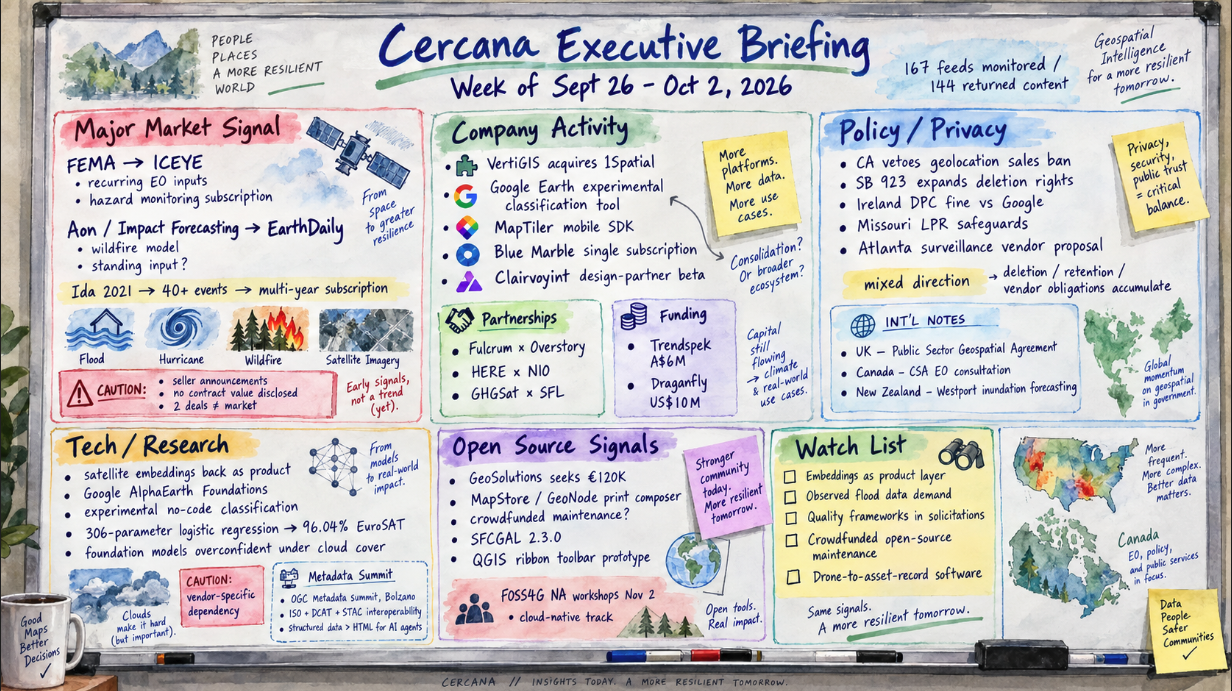
167 feeds monitored. Published October 2, 2026.
Executive Summary
Two buyers with real financial exposure to natural hazards committed this week to using Earth-observation products as recurring inputs. FEMA awarded ICEYE a multi-year, agency-wide hazard monitoring subscription after about five years of buying event by event. Aon’s catastrophe modeling team selected EarthDaily fuel data for a Canadian wildfire model. Both involve EO products moving into recurring risk workflows. There are important caveats: both announcements came from the sellers, neither gives a contract value, and two deals don’t establish a broader market pattern.
Other developments were less directly connected. VertiGIS closed its acquisition of 1Spatial, taking an independent data-quality vendor off the market. Location-data rules moved in different directions: California’s governor vetoed a ban on selling precise geolocation while signing an expansion of deletion rights, and Ireland’s regulator reportedly fined Google over location processing. Google also put its satellite embeddings inside a no-code classification tool, though only as an experiment.
The commercial questions remain open. Do subscription-style EO contracts get renewed? Do their values get disclosed? Does another buyer follow? Watch for terms on the FEMA award, other catastrophe modelers naming EO inputs, and quality-assessment frameworks appearing in government solicitations.
Major Market Signals
FEMA and Aon teams adopt recurring EO-derived hazard inputs
ICEYE reported that FEMA awarded it a multi-year Hazard Monitoring subscription covering every FEMA office, with radar-derived flood, hurricane, and wildfire products. The relationship dates to Hurricane Ida in 2021. By ICEYE’s count, the agency used its data across more than 40 events before signing the subscription. In an unrelated announcement, EarthDaily said Impact Forecasting, Aon’s catastrophe model development team, chose its conifer fuel dataset as an input to a Canadian wildfire model. Impact Forecasting’s statistical lead said the data improved accuracy when tested against recent fires.
One buyer is public and one is commercial. The common feature is recurring use rather than an event-specific purchase. Whether that represents a broader market shift isn’t yet clear. September 30 is the end of the US fiscal year, vendors announce wins when they have them, and neither announcement discloses value, term, or exclusivity. We hold the broader interpretation at medium confidence.
The FEMA timeline is also worth watching. The relationship developed over roughly five years and more than 40 events before moving to a subscription. Disclosed contract values, a renewal, or another insurer or agency signing on similar terms would provide more evidence of a broader purchasing pattern. A return to event-by-event purchasing would point the other way.
Notable Company Activity
Product Releases
- Google Earth: Released an experimental classification tool on the web. Users label sample points and get a custom categorical map built on the AlphaEarth Foundations satellite embedding dataset and a random forest classifier. Google gave no pricing and no date for general availability.
- MapTiler: Announced a mobile SDK for native maps on iOS and Android.
- Blue Marble Geographics: Folded previously separate Global Mapper desktop applications and services into a single subscription, which it describes as groundwork for field workflows.
- Clairvoyint AI: Opened a design-partner beta for a platform that packages geospatial methods as reusable AI agents. It’s a beta, so there’s no adoption data yet.
- GIS Cloud: Says its user growth has doubled and that more than 100 users join each day. Without a total user base or revenue figure, the claim can’t be sized.
Partnerships
- Fulcrum × Overstory: Announced a technical integration. Overstory’s vegetation-risk analysis, drawn from lidar and other remote sensing, arrives in Fulcrum as field assignments, and what crews confirm on the ground goes back to Overstory. No customer deployments were named.
- HERE × NIO: Expanded their commercial agreement to supply map data across NIO’s European vehicle lineup.
- GHGSat × SFL Missions: GHGSat awarded SFL a contract to develop the GHGSat-D2 demonstration satellite. No value was disclosed.
Funding & M&A
- VertiGIS / 1Spatial: VertiGIS completed its acquisition of 1Spatial’s worldwide business on October 1. Spatial Source puts the deal at $166 million but doesn’t specify the currency. The transaction was announced earlier in 2026.
- Trendspek: The Australian maker of 3D asset-record software raised A$6 million in a round led by OIF Ventures. It reports more than 860 customer organizations. The round type wasn’t stated.
- Draganfly: Took in US$10 million, half as a strategic investment from Unusual Machines and half from an undisclosed US fund. This is financing for a drone manufacturer and sits adjacent to the geospatial software market rather than inside it.
Government and Policy Developments
Most of the week’s government news concerned location privacy, and all of it reached us through one source, the GeoAI and the Law newsletter. We didn’t check the items against the primary texts. According to the newsletter, California’s governor vetoed AB 1542, which would have replaced the state’s opt-out regime for selling precise geolocation with a flat ban. He signed SB 923, which, beginning January 1, 2027, extends deletion rights to personal data a business obtained from third parties. The same issue reports a €403 million fine by Ireland’s Data Protection Commission against Google for location processing between 2018 and 2020, a Missouri executive order on license-plate reader safeguards, and a proposed Atlanta ordinance that would bar surveillance vendors from monetizing the data they collect.
The actions point in different directions. California rejected an outright prohibition on selling precise geolocation while expanding deletion rights. The other reported actions concern location processing, retention, or the handling of data by vendors. Together, they show several different regulatory approaches rather than a single policy direction.
The FEMA award belongs here too. It’s an operational commitment and no longer a trial, though the terms remain undisclosed. EarthDaily used its blog to draw attention to the Joint Optical Guidelines that NASA, ESA, and USGS signed in April, a voluntary, non-binding framework for judging commercial optical data on calibration, uncertainty, and validation. The framework is five months old, and the post is a vendor’s commentary on it. Its commercial significance will be easier to assess if agencies begin citing it in programs such as NASA’s commercial data acquisition.
In the UK, the Government Digital Service outlined the next phase of the Public Sector Geospatial Agreement, through which about 6,500 public bodies get Ordnance Survey data. It cited an independent estimate of £9.50 in societal benefit for every £1 of public funding but gave no renewal date or funding commitment. Smaller items: the Canadian Space Agency opened a consultation on EO application development that closes November 6, with no funding attached; the Cook Islands adopted a national geospatial information framework; and New Zealand switched on an inundation forecasting system covering Westport, a single town.
Technology and Research Trends
Satellite embeddings had been quiet in the feeds since spring. They came back this week in an experimental product. Google’s classification tool uses its AlphaEarth Foundations embeddings, while TerraWatch’s biweekly newsletter argued that embeddings are becoming products in their own right.
TerraWatch also highlighted an interoperability issue: embeddings from different models can’t necessarily be compared unless they were designed to be. Using one vendor’s embedding stack can therefore create a model-specific dependency that differs from using open imagery directly. One company’s experimental release and one analyst’s interpretation don’t demonstrate broader adoption.
Two research items provide reference points for evaluating model claims. GeoSpatial ML showed that a logistic regression with 306 learned parameters reaches 96.04% test accuracy on the EuroSAT benchmark using 33 fixed spectral and spatial measurements per image patch. That’s one benchmark, but the result provides a small-model baseline against which larger-model EuroSAT results can be compared. The Spatial Edge summarized a study finding that geospatial foundation models become overconfident under cloud cover; we didn’t review the underlying paper.
On standards, OGC reported from its September metadata summit in Bolzano, which drew more than 60 people in person from 39 organizations. Participants chose to work on interoperability among the ISO, DCAT, and STAC approaches rather than pursue a single standard. Demonstrations there indicated that AI agents handle structured formats such as GeoJSON and JSON-LD more reliably than HTML pages. The summit produced priorities rather than a new specification. A second summit is set for Ottawa on November 4–5.
Open Source Ecosystem Signals
GeoSolutions is asking its users for €120,000 to bring a new print composer for MapStore and GeoNode to production, using a new open-source print engine built on GeoTools. Contributions start at €500 and pledges close March 31, 2027. The company says it will fund part of the work itself and points to GeoServer 3, which was financed the same way. The campaign provides another observable case of users being asked to fund development of shared open-source infrastructure. The announcement doesn’t say what happens if the target is missed.
Oslandia announced SFCGAL 2.3.0. The open-source 3D geometry library gains 3D primitives, experimental NURBS curves, roof-generation tools, and a command-line client. In the QGIS world, Anita Graser published version 0.5 of an experimental ribbon-toolbar plugin, ported to QGIS 4. She calls it a prototype meant to start a discussion and says it isn’t production-ready. Oslandia also shared a roundtable on the state of plugin development. These releases indicate ongoing development activity but don’t provide information about maintainer capacity or funding.
FOSS4G North America opens with workshops on November 2. Its organizers published a cloud-native program and materials addressing public-sector concerns about support and migration.
Watch List
- Embeddings as a product layer: One vendor shipped an experimental tool on its own embeddings this week. A comparable product from another provider, or a customer reporting production use, would provide evidence that the pattern extends beyond one vendor. If the thread goes quiet for another month, we’ll drop it.
- Regulatory demand for observed flood data: ICEYE is pitching radar-observed flood extents to UK banks that fall under the Prudential Regulation Authority’s SS5/25 climate-risk expectations. So far, this is vendor positioning. Evidence would strengthen if a bank or the supervisor names observed-event data as an accepted input.
- Quality frameworks in solicitations: The NASA, ESA, and USGS guidelines are voluntary. We’re watching for a solicitation or award that cites conformity as an evaluation factor.
- Crowdfunded open-source maintenance: The GeoSolutions campaign is a single case. Reaching the goal would show that users were willing to co-fund this project. Another project using a similar model would provide evidence that the approach extends beyond a single campaign.
- Drone-to-asset-record software: Trendspek’s raise and the Fulcrum integration both tie remote capture to maintenance records, though for different customers. Neither item includes measured results from an asset owner.
Top Posts of the Week
- FEMA awards ICEYE an agency-wide natural disaster monitoring subscription: ICEYE Blog. The primary source for the week’s main signal, including the five-year path from pilot to subscription.
- Impact Forecasting Selects EarthDaily Wildfire Intelligence to Support Catastrophe Modeling Across Canada: EarthDaily. A named insurance-sector buyer of EO-derived data, which the feeds rarely produce, with a validation statement from the customer.
- GeoAI and the Law Newsletter: GeoAI and the Law. Our only source for this week’s location-privacy developments in California, Ireland, Missouri, and Atlanta.
- Earth Observation Essentials: September 28, 2026: TerraWatch Space. Independent analysis of embeddings as products and the dependencies they create.
- What We Learned in Bolzano — and What Comes Next for Geospatial Metadata: Open Geospatial Consortium. The standards body’s own account of where metadata interoperability and machine readability are headed.
Cercana Executive Briefing is generated from 167 feeds aggregated by geofeeds.me.