
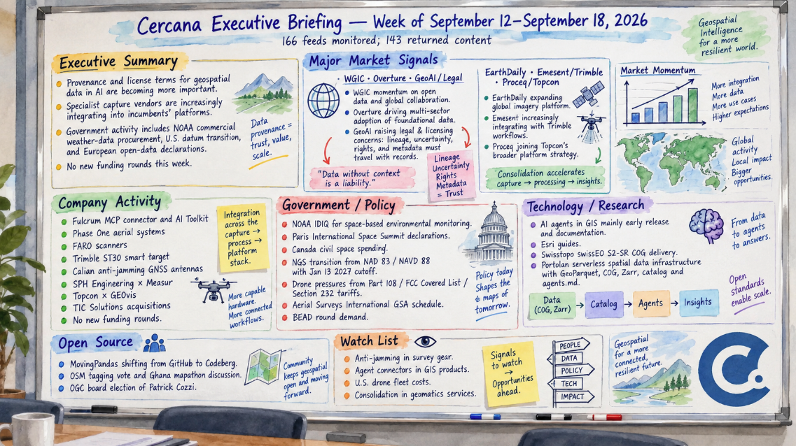
166 feeds monitored. Published September 18, 2026.
Executive Summary
Three unrelated organizations raised versions of the same issue this week: geospatial data becomes harder to trust inside AI systems when its lineage and license terms don’t travel with it. The World Geospatial Industry Council addressed the issue in a formal report, Overture Maps described it in the context of its own data pipeline, and a legal newsletter examined it through contract terms. None of the three, however, represents direct evidence of buyer behavior, and each has an interest in the industry taking the issue seriously. For now, the activity shows the industry working through questions that may increasingly surface in procurement and licensing.
The more commercial story was in field data. Sensor and data companies are increasingly appearing inside other firms’ platforms: EarthDaily inside an engineering firm’s tailings system, Emesent inside Trimble’s software, and Proceq’s radar inside Topcon’s workflow. Two of the three announcements came from INTERGEO, so the timing deserves some caution. The EarthDaily deal, however, is a five-year commercial contract and stands apart from the trade-show announcements.
Government activity centered on procurement vehicles, reference-frame transition, and nonbinding European data declarations. NOAA formalized a multi-vendor route for buying commercial weather data, the US set a 2027 cutoff for submissions using its old datum, and European governments signed open-data declarations without binding commitments. The feeds carried no new funding rounds.
What to watch: provenance language appearing in RFPs and licenses, and any usage numbers behind this week’s platform integration announcements.
Major Market Signals
Lineage and license terms are becoming a focus in AI use of geodata
WGIC’s Data to Decisions report, published September 15, argues that the industry is shifting from trusting measurements to trusting models. It proposes six tests for “decision-grade” data, including provenance, stated uncertainty, and clear rights. Two days later, Overture’s CTO made a narrower, more practical point. AI agents pull individual records out of datasets and recombine them, so a license or lineage note written once for an entire dataset can get separated from the records themselves. Overture’s approach is to attach metadata at the start and carry it through each processing step. The same day, the GeoAI and the Law newsletter published a licensing guide showing how an “internal use” grant drafted before anyone trained models on imagery may say little about model weights, inference outputs, or products built from them.
This week’s items converge on the same potential failure point, but all three sources are advocates rather than buyers. The legal guide says procurement questionnaires already ask about training-data provenance, but broader evidence of changing buyer behavior remains limited. The signal would strengthen if provenance clauses begin appearing more visibly in public-sector RFPs, licensing terms, or OGC work. Medium confidence.
Specialist capture vendors are selling through incumbents’ platforms
EarthDaily signed a five-year agreement as preferred InSAR provider to an unnamed global engineering firm. Its Iris deformation service will run inside the firm’s existing tailings platform, starting with a major mining client and replacing periodic reports. At INTERGEO, Emesent connected its mobile SLAM scanners to Trimble Connect and Trimble Business Center, while Proceq’s ground-penetrating radar was paired with Topcon’s GNSS and data software for EMEA infrastructure work.
In each case, the specialist technology is being incorporated into a workflow customers already use rather than requiring a separate interface. The caveat is timing: trade shows generate integration announcements, and an integration alone says nothing about adoption. The EarthDaily contract, which isn’t tied to INTERGEO, carries more weight because it represents a multi-year commercial arrangement. If similar deals continue, specialists may increasingly compete on their ability to fit into platforms that already own the customer workflow. Disclosed customer volumes, usage, or renewals would strengthen the signal. Medium confidence.
Notable Company Activity
Product Releases
- Fulcrum: Put an MCP connector and AI Toolkit into its Fulcrum Labs early-release program. Crews describe a field process in plain language and get back an offline workflow. It’s not yet generally available.
- Phase One: Released its Next-Generation Aerial Systems, a modular aerial imaging platform with hybrid motion compensation.
- FARO (AMETEK): Showed the Focus i.1 and i.1 X terrestrial scanners and the Rovi i.1 capture package at INTERGEO and Autodesk University.
- Trimble: Announced the ST30 smart target for optical surveying, with GNSS built in.
- Calian: Added survey-grade and full-band anti-jamming GNSS antennas, pointing to interference conditions in Europe as the reason.
Partnerships
- SPH Engineering × Measur: Measur is now SPH’s Canadian master distributor for selected drone sensors in mining, hydrography, geophysics, and utilities. The arrangement is a reseller agreement.
- Topcon × GEOvis: Topcon’s Delta Watch deformation monitoring now runs on GEOvis, bringing total station, GNSS, and geotechnical sensor data into one view.
Funding & M&A
- TIC Solutions / GeoVerra, we-do-IT, Core Group: GoGeomatics covered this on September 15, but TIC announced the completed acquisitions on August 18. Together, the three add about US$90 million in annualized revenue. Prices weren’t disclosed, and TIC paid cash. GeoVerra gives TIC, which already owns NV5, a national geomatics presence in Canada.
- No new funding rounds appeared in the feeds. The Geospatial Jobs newsletter’s fundraising section was also empty.
Government and Policy Developments
On September 10, a few days before this window, NOAA named 14 companies to its Space-Based Environmental Monitoring IDIQ, covering radio occultation, reflectometry, microwave sounding, SAR, and several other data types for up to ten years. TerraWatch puts the ceiling at $2.35 billion. Being named on an IDIQ means a company is eligible to compete for task orders, not that it will receive that amount. The vehicle also grows out of a commercial-data pilot NOAA started in 2016, so it represents a continuation and formalization of an existing approach rather than an abrupt change in direction.
European governments took a different approach, at least in declared principle. TerraWatch examined two declarations from the Paris International Space Summit on September 9 and 10: one on open, traceable space science data, signed by 49 countries and ESA, and another calling Copernicus a global public good whose continuity matters, signed by 27 countries and five organizations. Neither creates an institution or commits participants to a specific dataset. Canada, meanwhile, spent 0.043% of GDP on civil space in 2025 against an OECD average of 0.065%, according to OECD figures reported by GoGeomatics, and the CSA’s budget is heading down after a one-off increase tied to ESA programs.
In the United States, EarthStuff flagged the National Geodetic Survey’s replacement of NAD 83 and NAVD 88 with new reference frames and a geopotential datum. Published coordinates will move by up to several meters even though nothing on the ground does. The change has been scheduled for years, but the post reports that the old system will stop accepting new submissions after January 13, 2027. That creates a concrete transition date for surveyors, floodplain mappers, and organizations maintaining large GIS databases.
US drone operators are also dealing with several policy and cost pressures at once: the pending Part 108 BVLOS rule, the FCC Covered List, and Section 232 tariffs of up to 100% that took effect September 3, according to coverage of Commercial UAV Expo. Aerial Surveys International won a GSA Multiple Award Schedule contract for GIS and Earth observation services, allowing it to bid as a prime after nearly 30 years as a subcontractor. IQGeo’s breakdown of NTIA’s second BEAD round, roughly $21 billion, is a vendor’s reading of the program but points to continued spending on broadband network planning.
Technology and Research Trends
AI agents are appearing in GIS products mainly through documentation and early releases rather than broadly available production features. Esri published a walkthrough for building Experience Builder widgets with a coding agent and shared “Agent Skill,” along with a separate guide to using embeddings in ArcGIS Pro analysis. Together with Fulcrum’s early release, these show vendors preparing their products for AI-assisted workflows. There’s not yet evidence in this week’s material of teams using these capabilities at scale.
Cloud-native infrastructure produced more concrete releases. Swisstopo’s swissEO S2-SR version 200 now delivers all 13 Sentinel-2 bands as COGs in under a day, with an AI-based cloud and terrain-shadow mask, according to Spatialists. Chris Holmes described Portolan, a serverless spatial data infrastructure that publishes GeoParquet, COG, and Zarr in a bucket alongside catalog and agents.md files so machines can read the collection as readily as people. That model also offers one way for publishers to keep machine-readable context alongside cloud-native data.
Most research in the feeds this week appeared as conference presentations, including University of Würzburg Earth observation work on biodiversity and forest condition at NSO-GfÖ in Odense. These are research results rather than commercial products.
Open Source Ecosystem Signals
Anita Graser is moving MovingPandas development from GitHub to Codeberg. The GitHub repositories will remain available as read-only mirrors, while issues and pull requests there will be disabled and Codeberg’s LLM usage policies will apply. She cites a positive year running Trajectools on Codeberg as well as worsening GitHub performance. One maintainer’s decision isn’t evidence of a broader migration, but it does illustrate how repository-platform choices can affect contributors and downstream users whose tooling assumes GitHub.
In OpenStreetMap, weeklyOSM reported a vote on a contested tagging proposal closing September 19 and a State of the Map talk arguing that paid mapathon campaigns may be crowding out volunteer mappers in Ghana. Both touch on governance questions around how the map is produced and maintained. OGC also elected Cesium founder Patrick Cozzi, now Bentley’s Chief Platform Officer, to its board, adding a member closely associated with 3D geospatial and digital-twin platforms to the organization’s governance.
Watch List
- Anti-jamming in survey gear: Calian is pitching interference-resistant antennas to surveyors, not just defense customers. Upgrade this if other survey GNSS vendors make interference mitigation a standard specification; drop it if the capability remains concentrated in defense-oriented products.
- Agent connectors in GIS products: So far, the feeds show one early-release MCP connector and one vendor guide. Upgrade when a connector becomes generally available with published usage or security terms, or when a second major platform ships one.
- US drone fleet costs: Tariffs and the Covered List are in force. Upgrade when operators or service firms disclose effects on fleet costs, availability, or pricing, or when Part 108 is finalized.
- Consolidation in geomatics services: TIC’s deal predates this window. Upgrade if TIC or a rival announces additional surveying acquisitions this quarter.
Top Posts of the Week
- WGIC Unveils New Report: “Data to Decisions: Rebuilding Trust in Decision-Grade Geospatial Data”, Earth Imaging Journal. The primary source for the provenance signal and its six-part test for decision-grade data.
- How do you trust open map data in an agentic AI world?, Overture Maps Foundation. A practical explanation of why dataset-level metadata can break down when agents extract and recombine individual records.
- GeoAI and the Law Newsletter, GeoAI and the Law Newsletter. Translates the provenance issue into specific licensing and contract questions.
- EarthDaily Selected as Preferred InSAR Provider for Global Engineering Firm’s Tailings Management Platform, EarthDaily. The multi-year commercial contract supporting this week’s platform-integration signal.
- Can a Global Earth Observation Accord Work, Even If It Is Not Global?, TerraWatch Space Newsletter. An independent look at what the Paris declarations commit governments to and what they leave unresolved.
Cercana Executive Briefing is generated from 166 feeds aggregated by geofeeds.me.