
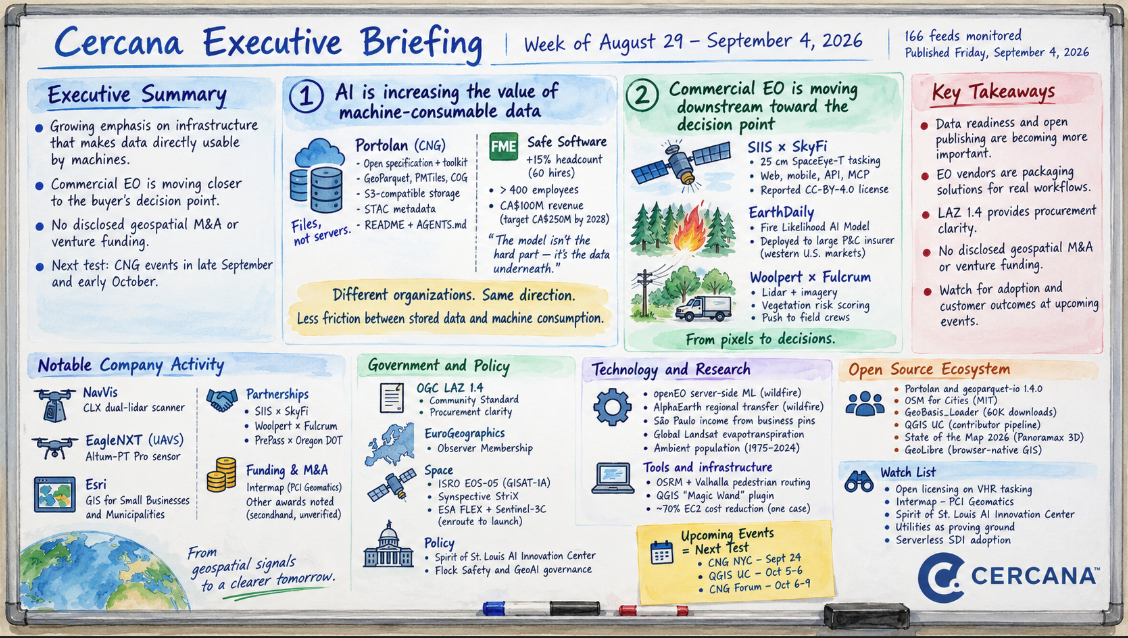
166 feeds monitored. Published Friday, September 4, 2026.
Executive Summary
The strongest signal in this week’s feeds was a growing emphasis on infrastructure that makes data directly usable by machines. The Cloud-Native Geospatial Forum launched Portolan, an open-source specification and toolkit for publishing geospatial data as well-organized files in object storage. On the commercial side, Safe Software disclosed a 15 percent headcount expansion and attributed its growth in part to customers discovering that the hard part of AI isn’t necessarily the model; it’s getting the underlying data into shape. The two aren’t evidence of the same market behavior, but they point in the same direction: reducing the friction between stored data and machine consumption is becoming more important.
A second, narrower pattern showed up in commercial Earth observation. Three unrelated announcements — a 25 cm tasking marketplace, a wildfire-likelihood model sold to an insurer, and lidar-derived vegetation risk pushed to utility field crews — all move closer to the buyer’s decision point rather than simply selling imagery. None discloses revenue or customer outcomes, so this is evidence of positioning, not yet demand.
There was no disclosed geospatial M&A or venture funding in the feeds reviewed, and procurement news reached the corpus only secondhand. The next question for the first signal is whether serverless publishing and similar approaches spread beyond the communities building them. CNG events in late September and early October should offer an early test.
Major Market Signals
AI is increasing the value of infrastructure that makes data machine-consumable
Observed. On September 2, the Cloud-Native Geospatial Forum launched Portolan: a specification, validator (rashid), CLI, agent skills, and public registry for publishing geospatial data as GeoParquet, PMTiles, and COG in S3-compatible storage, with STAC metadata and mandatory README and AGENTS.md documentation. The post cites Fields of the World, a 369 TB catalog that served 106.6 TB in the 28 days to August 27 with no dedicated serving layer in front of it. On August 31, Chris Holmes released geoparquet-io 1.4.0 and credited Portolan conversion work with much of the progress since 1.0.
Separately, Spatial Source reported on September 3 that Safe Software plans 60 hires by year-end, taking headcount past 400. The company says it reached CA$100 million in revenue last year against a CA$250 million target for 2028. Its CEO attributed some of the demand to customers discovering that the model isn’t the hardest part of AI. An FME blog post the same week made a similar argument for utility AI projects.
Interpretation. Portolan and geoparquet-io are part of one technical workstream. Safe Software is independent commercial evidence of a related problem. The connection isn’t that serverless SDI and data preparation are the same thing. It’s that both reduce the distance between data as stored and data as consumed by software, analytics, and AI systems. As machine-generated query volumes rise, that layer becomes more important.
Alternative explanation. Safe’s disclosed hiring skews toward sales, revenue operations, and marketing, which also looks like a growing private company scaling go-to-market. The AI framing may be positioning rather than the cause of growth, and its figures are self-reported and unaudited. Portolan’s release also precedes CNG NYC on September 24 and the CNG Forum on October 6–9, so its timing may reflect the event calendar as much as market readiness.
Implication. Data publishers can test the Portolan architecture on fairly concrete terms: storage and egress costs, operational complexity, and performance compared with a dedicated serving tier. More broadly, vendors whose value proposition depends on standing up proprietary serving infrastructure now have to contend with increasingly capable alternatives built around open formats and object storage.
Confidence: Medium. Watch: a national mapping agency adopting Portolan or a similar architecture as an official publication path; Esri’s response in ArcGIS publishing workflows; Safe reporting AI-attributed revenue rather than headcount.
Commercial EO is moving downstream toward the decision point
Observed. Three unrelated announcements this week point in that direction. SI Imaging Services partnered with SkyFi to make native 25 cm SpaceEye-T tasking orderable through SkyFi’s web, mobile, API, and MCP interfaces; Spatial Source reports the imagery is licensed CC-BY-4.0. EarthDaily’s September Monitor says it has an agreement with an unnamed large North American property-and-casualty insurer to deploy its Fire Likelihood AI Model across high-risk western U.S. markets. Woolpert and Fulcrum announced a partnership that scores vegetation encroachment from corridor lidar and imagery, then pushes prioritized work into Fulcrum’s field-operations platform.
Interpretation. Each pushes the commercial offering closer to something the buyer actually does: order new collection, make an underwriting decision, or dispatch vegetation-management work. That’s a different position in the value chain from selling imagery or derived data alone. If the pattern continues, differentiation may increasingly come from owning the connection to the customer’s workflow rather than the sensor.
Alternative explanation. They’re all vendor announcements with no customer-disclosed outcomes. EarthDaily’s counterparty is unnamed; Woolpert–Fulcrum is a partnership rather than a reported deployment; and SIIS–SkyFi is a distribution arrangement. There’s not enough here to infer that buyers are shifting budgets.
Implication. Buyers evaluating EO vendors should look beyond sensor specifications to workflow integration, licensing, and where the product enters the decision process. If the CC-BY-4.0 claim for SpaceEye-T holds up at the primary source, it’s unusual for tasked very-high-resolution imagery and could be commercially more significant than the 25 cm resolution.
Confidence: Medium. Watch: named customers, renewals, or pricing for any of the three; a second VHR operator adopting open licensing; customer evidence that workflow integration affected a purchase decision.
Notable Company Activity
Product Releases
- NavVis: Launched the CLX dual-lidar scanner for as-built documentation and reality capture, covered independently by Spatial Source and Earth Imaging Journal. Announced, but not yet independently evaluated.
- EagleNXT (AgEagle, NYSE: UAVS): Unveiled the Altum-PT Pro drone sensor, combining multispectral, panchromatic, and radiometric thermal capture in one payload.
- Esri: Announced a “GIS for Small Businesses and Municipalities” initiative covering success stories, a partner directory, and resources, along with an ArcGIS Pro product life-cycle update. The latter couldn’t be retrieved for detail.
Partnerships
- SIIS × SkyFi: Distribution arrangement making SpaceEye-T 25 cm archive imagery and tasking orderable through SkyFi.
- Woolpert × Fulcrum: Integration partnership connecting corridor risk scoring to field-crew work management for utility vegetation programs.
- PrePass Safety Alliance × Oregon DOT: Statewide rollout of the PrePass Bypass mobile app for commercial vehicle screening.
Funding & M&A
- Intermap (TSX: IMP): A syndicated analysis revisited Intermap’s August 13 results, including Q2 revenue of about US$2.0 million, down 33 percent, and its planned acquisition of PCI Geomatics, expected to close this quarter. No new facts emerged this week.
- The Geospatial Jobs newsletter relayed a US$74.2 million Space WERX award to Moun Space, a US$28 million NOAA grant to Spire, and a US$49 million NOAA contract to Tomorrow.io. These were secondhand and undated in the feed, so they’re noted but not verified.
Government and Policy Developments
The most durable public-sector item was OGC’s publication of the LAZ 1.4 Community Standard on September 3. It ratifies a compression format already in wide use rather than adding new capability. Its practical value is procurement clarity: agencies can now reference an OGC document when specifying LAZ 1.4 rather than relying on a vendor library as the de facto definition.
EuroGeographics launched an Observer Membership category, creating a formal way for non-European national mapping and cadastral agencies to participate. Whether agencies actually join will determine how significant the change is.
On the space side, ISRO’s EOS-05 (GISAT-1A) reached geostationary orbit, giving India continuous coverage of the subcontinent, while Synspective added another StriX SAR satellite via Rocket Lab. ESA’s FLEX and Sentinel-3C are also enclosed for a mid-September Vega-C launch. These are separate additions to observation capacity rather than a coordinated event.
Two policy-adjacent items stood out. Project Geospatial published a skeptical reading of the Spirit of St. Louis AI Innovation Center, announced August 26 and administered by a new nonprofit, GeoSTL. The critique is that the “AI for good” framing hasn’t yet been matched by disclosed compute access, tenants, or funding terms. The GeoAI and the Law newsletter tracked backlash to Flock Safety’s license-plate reader network and outlined a risk-based GeoAI governance structure aligned with the EU AI Act and Colorado’s AI Act.
Technology and Research Trends
Some of the technical activity echoed the first Major Market Signal. Development Seed published a walkthrough of openEO server-side machine learning for wildfire analysis, demonstrating an approach in which computation moves to the data rather than requiring large datasets to move to the analyst. It’s a demonstration, not an operational deployment.
The Spatial Edge newsletter summarized a study reporting that AlphaEarth embeddings transfer between regions for wildfire risk without retraining. A separate Bowdoin–PUC-Campinas study estimated São Paulo neighborhood income from Google Maps business pins. Both are single studies, but each addresses a recurring geospatial ML problem: whether models or representations developed in one context can carry useful information into another.
Two public datasets also surfaced with clear provenance: an on-demand global Landsat evapotranspiration product published in Remote Sensing of Environment and an annual ambient population series for 1975–2024. The population dataset is an EarthArXiv preprint and hasn’t been peer-reviewed.
Practitioner posts pointed to smaller tooling shifts. OSRM and Valhalla now route pedestrians across open areas rather than around their edges. A “Magic Wand” QGIS plugin digitized polygons from imagery in seconds. One engineer documented a roughly 70 percent EC2 cost reduction on an EO workload by designing for Spot interruption. That’s one account, so the number shouldn’t be generalized, but the architecture is worth noting.
Open Source Ecosystem Signals
CNG describes Portolan as an open-source specification and toolkit, though the specific license wasn’t stated in the announcement. geoparquet-io 1.4.0 is confirmed open source, and the release credits three new contributors, including one converting ArcGIS Server catalogs for Portolan. It’s a modest but concrete indication that use is beginning to spread beyond the project’s maintainer.
Vitor George’s OSM for Cities, an MIT-licensed change-detection and digest service for OpenStreetMap, was also flagged by Spatialists.
Community health indicators were mixed. The GeoBasis_Loader QGIS plugin passed 60,000 downloads with 877 German geodata layers and a v2.2 release pending. That’s a notable success for a small named team, but it also highlights maintainership concentration. The QGIS User Conference program for October 5–6 in Laax includes talks on converting users to contributors and on maintainer mental health. Contributor pipeline and burnout are clearly on the community’s agenda.
State of the Map 2026 concluded in Paris on August 30. Oslandia’s recap points to Panoramax 3D integration as the most substantive technical item.
A recorded talk on GeoLibre also circulated via Open Geospatial Solutions. It’s presented as an open-source, browser-native GIS built on COG, GeoParquet, PMTiles, DuckDB, and WebAssembly, though its license wasn’t verified from the feed.
Watch List
- Open licensing on commercial VHR tasking: Spatial Source reports SIIS–SkyFi imagery is licensed CC-BY-4.0. Promote if confirmed at the primary source and a second commercial VHR operator adopts comparable terms, or if a buyer cites licensing as a purchase reason. Drop if the claim applies only to specific order types.
- Intermap–PCI Geomatics: The acquisition is expected to close this quarter. Promote when it closes with disclosed consideration and integrated guidance; drop if it slips past year-end.
- Spirit of St. Louis AI Innovation Center: Announced with a new nonprofit backbone but no disclosed compute-access terms. Promote if named tenants, funding, or GEOINT-specific programs are published. Drop if it’s still just an announcement through Q4.
- Utilities as the AI/GIS proving ground: Safe and Woolpert–Fulcrum both targeted utility budgets this week. Promote if a utility discloses a deployment with measured outcomes; drop if the pattern remains entirely vendor-side.
- Tests of the serverless-SDI thesis: CNG NYC on September 24 and the CNG Forum on October 6–9 provide near-term opportunities for agency or commercial adoption announcements. QGIS UC on October 5–6 may also show how far object-storage and cloud-native publishing patterns are moving into mainstream practitioner workflows.
Top Posts of the Week
- Introducing Portolan: A serverless spatial data infrastructure — CNG Blog — Primary source for the week’s most important technical release, including disclosed throughput figures for a serverless catalog in production.
- Safe Software bucks the AI workforce trend — Spatial Source — Independent commercial evidence for the data-readiness argument, with headcount, revenue, and turnover figures.
- SIIS partners with SkyFi for 25cm optical imagery — Spatial Source — Establishes the tasking-marketplace facts and carries the licensing claim on the Watch List.
- OGC Announces Publication of the LAZ 1.4 Community Standard — Open Geospatial Consortium — Primary source for the week’s enacted standards development.
- GeoAI and the Law Newsletter — GeoAI and the Law Newsletter — The only feed voice this week covering regulatory exposure around location surveillance and GeoAI governance.
The Cercana Executive Briefing is generated from 166 feeds aggregated by geofeeds.me.