
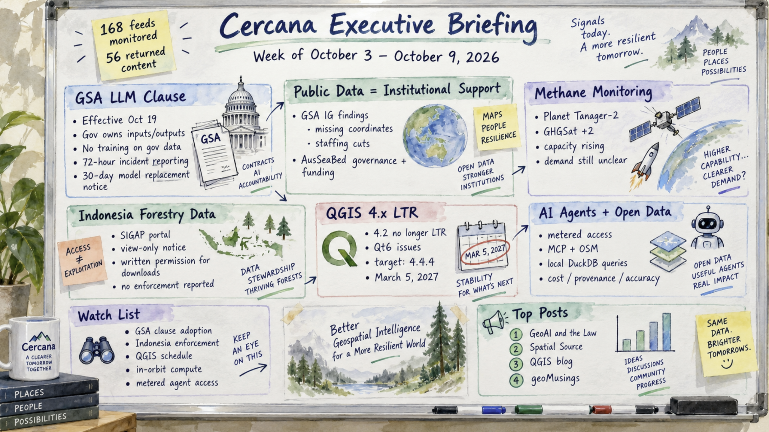
168 feeds monitored. Published October 9, 2026.
Executive Summary
The US General Services Administration (GSA) has issued terms governing large language model systems sold through its purchasing vehicles, effective October 19. According to a legal analysis published this week, the government retains ownership of its data and anything fine-tuned on it, vendors can’t use that data for training, and contractors face firm deadlines for incident reporting and model replacements. The requirements could affect geospatial vendors incorporating assistants or agents into products sold to federal customers.
Two reviews published this week, one in Washington and one in Canberra, raised similar concerns about public geospatial data. In both cases, the findings involved institutional responsibility, staffing, and funding rather than technical shortcomings alone.
Earth observation capacity continued to grow. Two unrelated operators launched methane-monitoring satellites on the same rocket, adding capacity to a market where the pace of demand growth remains unclear.
Investment activity was relatively quiet. We found no acquisitions of geospatial-core companies or large funding rounds among the items reviewed. In open source, QGIS deferred long-term-release status for its 4.x line to an anticipated March 2027, affecting the planning of agencies and firms that deploy only those releases.
Developments to follow include how contracting officers apply the GSA clause, whether Indonesia enforces its restrictions on forestry data downloads, and whether QGIS meets its revised release date.
Major Market Signals
Structural event: Federal procurement introduces new data terms for LLM-enabled products
GSA issued clause GSAR 552.239-7001 as a class deviation, effective October 19, 2026. One caveat is important: our account relies on the GeoAI and the Law newsletter, written by a practicing attorney. We haven’t independently reviewed the clause itself.
As summarized in the newsletter, the clause applies when an LLM is a material feature of a purchased product or service and government data is involved. The government retains ownership of inputs, outputs, and custom developments, including fine-tuned weights. Contractors can’t train models on government data. Incidents must be reported within 72 hours, and model replacements require 30 days’ notice. At contract closeout, government data must be removed, along with embeddings and indexes derived from it. The requirements flow down to subcontractors and supersede conflicting commercial license terms.
For a geospatial vendor selling an embedded assistant or agent through GSA purchasing vehicles, these requirements could apply regardless of whether the company primarily identifies as an AI provider. There is some room for interpretation. The clause exempts incidental LLM features that the government doesn’t use, and a class deviation is easier to revise than a permanent rule.
How the clause appears in actual solicitations, how contracting officers interpret its scope, and whether other agencies adopt similar terms will provide more clarity about its reach.
Public geospatial data depends on the institutions maintaining it
Spatial Source reported on two formal reviews this week that identified institutional weaknesses affecting public geospatial data on opposite sides of the Pacific.
GSA’s Inspector General found that the agency isn’t meeting Geospatial Data Act requirements to maintain a geospatial strategy and data inventory, and isn’t fully complying with its obligation to search for existing data before purchasing more. Of 8,475 GSA-controlled building records, 634 (7%) lacked distinct coordinates. Across the broader federal property dataset, the figure was 78,624 of 298,221 records (26%). Problems with searching for existing data had already been identified in a 2024 audit. The employee assigned to address them held a position eliminated during the 2025 workforce reductions.
In Australia, an independent review recommended bringing the AusSeaBed seabed-mapping program into Geoscience Australia. The review found that demand wasn’t the problem. Rather, the program had outgrown its existing governance and funding arrangements. All five government partners agreed with the recommendation.
The two reviews are unrelated, and their publication in the same week is coincidental. Nevertheless, both connect problems affecting public geospatial data to questions of institutional support. Staffing, governance, and responsibility for maintenance figure prominently in their findings.
The reports also raise questions about the long-term reliability of public datasets when their maintenance depends on programs or positions without lasting institutional support.
Methane-monitoring capacity is growing, but demand remains difficult to assess
SpaceX’s Transporter-18 rideshare mission on October 1 carried emissions-monitoring satellites for two independent operators. Planet launched Tanager-2, a hyperspectral satellite developed with Carbon Mapper that collects 426 spectral bands at 30-meter resolution, along with 18 SuperDoves. GHGSat added two microsatellites, bringing the number of spacecraft built for the company by its manufacturer to 13.
The GHGSat total is cumulative, as is Planet’s reported figure of 718 satellites built and delivered to orbit. Neither figure indicates how many satellites are currently operational.
The shared launch explains the timing, but the operators made their investments independently. Both are adding capacity to the methane-monitoring market. Meanwhile, research highlighted by The Spatial Edge described Google’s work mapping methane plumes using observations from NASA’s EMIT instrument, illustrating another source of methane-monitoring data.
Whether demand is growing at a comparable rate remains unclear. The feeds reviewed this week contained no new customer contracts, pricing disclosures, or regulatory mandates that would help establish the strength of the market.
Contracts with oil and gas operators or regulators, along with pricing and customer growth, could provide additional evidence about how the market is absorbing new capacity.
Notable Company Activity
Product Releases
- Planet: Delivered 20 satellites to orbit on October 1. One is a demonstration payload for Google’s Project Suncatcher, described as the first test of Google’s Tensor Processing Units in space. Commissioning status wasn’t reported.
- Blue Marble Geographics: Announced a three-tier Global Mapper subscription offering comprising Essentials, Advanced, and Professional. The upper two tiers bundle Geographic Calculator and MAPublisher. Pricing wasn’t disclosed, nor was the future of perpetual licenses.
- Esri: Published a workflow for interpreting USA Geodemographic Embeddings using AutoML and SHAP in ArcGIS Pro, with county-level food insecurity as the example. This is guidance on an existing capability rather than a new product release.
Partnerships
- PwC and Esri: PwC became the first systems integrator in the new Platinum tier of Esri’s partner program, with an emphasis on energy and infrastructure customers. No financial terms, product announcements, or implementation dates were disclosed. The announcement describes a channel partnership rather than a new customer offering.
Funding & M&A
- Blackswan Space: Closed a €2.5 million funding round led by Iron Wolf Capital, bringing total funding to €3.2 million. The Lithuanian company develops spacecraft autonomy and rendezvous technology, placing it in an adjacent market to Earth observation.
- Advanced Navigation: The Australian positioning company announced plans to establish a navigation and timing center in Alabama. The investment amount wasn’t disclosed.
No acquisitions of geospatial-core companies were identified among the items reviewed this week.
Government and Policy Developments
Indonesia’s Ministry of Forestry has posted a notice on its SIGAP geospatial portal restricting access to forestry data. The portal now describes the data as view-only and requires written permission to download it or convert it into formats such as Shapefile. The notice cites the country’s 2011 Geospatial Information Law.
Some reporting has conflated the restrictions with penalties for other activities. The cited penalties, including up to six months for unauthorized alteration and up to three years when harm results, concern altering data or distributing altered data. The three-year penalty doesn’t apply simply to downloading a file.
The ministry says the restrictions are intended to prevent falsification of forest boundaries and resale of public data. However, a Human Rights Watch researcher and an Indonesian law professor, both quoted by Spatial Source, argue that the restrictions conflict with the country’s 2008 public information law.
At present, this is a portal notice citing an existing statute, not a newly enacted regulation. No enforcement action has been reported. The restrictions may affect organizations conducting supply-chain analysis or deforestation monitoring using Indonesian forestry boundaries.
In Europe, Spectral Reflectance reported that ESA awarded ICEYE and Leonardo separate studies for a proposed Earth Observation Governmental Service architecture. Italy’s IRIDE program now has 39 satellites in orbit. The studies concern a potential governmental Earth observation capability but don’t establish a funded operational procurement. TerraWatch also covered Japan’s proposed 2027 Earth observation budget, but that report was paywalled and wasn’t independently reviewed for this briefing.
On September 29, the Third Circuit ruled in Thomson Reuters v. ROSS Intelligence. As summarized by GeoAI and the Law, the court held that training a competing product on a rival’s curated material did not qualify as fair use. The decision could have implications for companies training AI models on competitors’ curated mapping, imagery, or other geospatial information products, although the application to those products remains a separate legal question.
Technology and Research Trends
Two items this week addressed AI agents as consumers of open data, with different approaches to managing access and computational resources.
In a geoMusings post, Bill Dollins examined Overspan, a commercial service that provides access to a global OpenStreetMap query endpoint through a Model Context Protocol (MCP) interface. Its paid plans impose request limits and expose remaining quotas to the agent. The post distinguishes between the right to use openly licensed data and the operational cost of delivering that data through a service. Open licensing doesn’t resolve questions of infrastructure capacity, particularly when agents can generate queries without direct user involvement.
The Geospatial FM podcast demonstrated a different approach. A geoSQL skill developed by Dekart’s founder queries Overture and Esri data locally using DuckDB, allowing the model to inspect images of its own maps as it works. The demonstration also showed some limitations. The host’s test took several minutes, and a subsequent statewide analysis produced results he found difficult to interpret.
The examples represent two approaches to agent access: a metered hosted service and local data querying. Neither provides much evidence about adoption. Both involve questions about cost allocation, analytical accuracy, and provenance.
Planet’s Project Suncatcher payload is another development in this area. It’s an experiment in on-orbit computing, with no reported operational workflows yet.
Open Source Ecosystem Signals
QGIS 4.2 will no longer receive long-term-release (LTR) status as originally planned. The project reports unresolved issues in the 4.x series associated with its transition to the Qt6 framework and is reluctant to designate those builds as stable enough for long-term support.
LTR status is now anticipated for version 4.4.4 on March 5, 2027. To support that schedule, the project introduced a blocker tag for critical issues and extended its funded bug-fixing period from four weeks to six. Developers have also indicated that they may disable features that remain broken or delay the release further if necessary.
For agencies and organizations that deploy only LTR versions, the change extends reliance on the 3.x series and postpones some plugin migration work. The project has explicitly prioritized resolving outstanding stability issues over meeting the original date.
The project has made its criteria and contingency options public. The number of unresolved blockers ahead of the 4.4 release freeze will help indicate whether the revised schedule is achievable.
Elsewhere in the open-source ecosystem, the OpenStreetMap Foundation opened a community microgrant program with €5,000 available in total and individual awards capped at €500. The Overture Maps Foundation launched a contributor badge program, offering recognition rather than financial support.
Watch List
- Indonesia forestry data: The current restriction is a portal notice. Enforcement actions, a formal regulation, similar restrictions elsewhere, or withdrawal of the notice would clarify whether this represents a broader change in policy.
- In-orbit computing: One demonstration payload has reached orbit. Additional deployments or measured latency and cost results would provide more information about operational applications.
- Metered agent access to open data: Current examples include a commercial service and related commentary. Adoption of agent-specific quotas or pricing by a foundation-operated data service would indicate that the approach is spreading.
- European governmental EO service: Two architecture studies have been awarded. The next development would be a funded procurement decision.
- QGIS 4.x LTR schedule: March 2027 is the revised target. Another delay would further affect migration schedules for organizations relying on LTR versions.
Top Posts of the Week
- GeoAI and the Law Newsletter — GeoAI and the Law — Provides the only detailed account in the monitored feeds of the GSA procurement clause and the ROSS Intelligence ruling.
- Agency not fully complying with Geospatial Data Act — Spatial Source — Reports the Inspector General’s findings, including record counts and the staffing issues affecting remediation.
- Release schedule changes for next QGIS LTR — QGIS.org blog — The project’s primary-source explanation of its revised LTR schedule and blocker-management process.
- Planet Labs launches 20 EO satellites simultaneously — Spatial Source — Details the launch manifest and distinguishes Planet’s cumulative satellite deliveries from its active fleet.
- Revisiting Open Data and AI — geoMusings — Examines the operational costs and responsibilities associated with agent access to openly licensed geospatial data.
Cercana Executive Briefing is produced from 168 feeds aggregated by geofeeds.me.