
168 feeds monitored. Approximately 150 posts reviewed. Published Friday, October 30, 2026.
Executive Summary
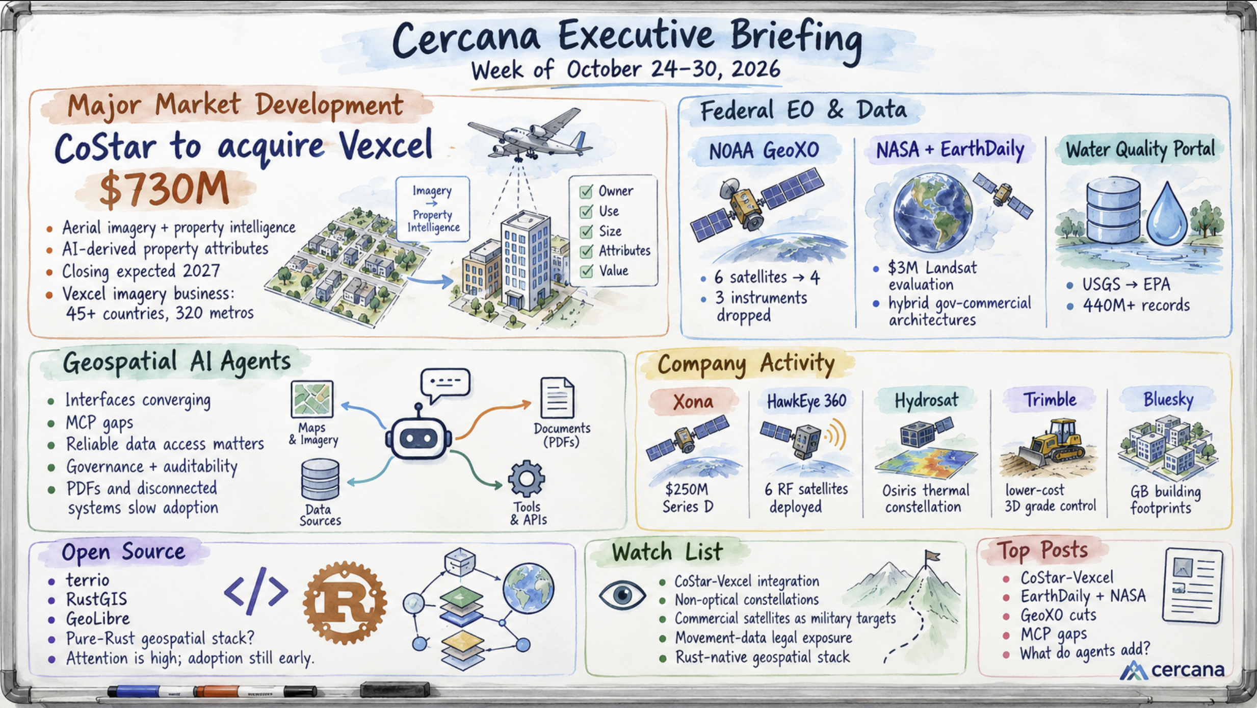
CoStar Group announced a $730 million agreement to acquire Vexcel this week, bringing a major aerial-imagery collection and processing business into its property information operation. CoStar plans to use Vexcel imagery and AI to generate detailed property attributes at scale. The acquisition would give CoStar greater control over the data used in its analytical products, while potentially changing the relationship between Vexcel and its existing customers in insurance, infrastructure, and other markets. The transaction is subject to regulatory approval, with closing expected in 2027.
Federal Earth observation programs presented a different set of developments. A GAO report detailed reductions to NOAA’s GeoXO weather-satellite program, while NASA awarded EarthDaily $3 million to evaluate commercial imagery against Landsat requirements. A firsthand account also described the transfer of operational responsibility for the Water Quality Portal from USGS to EPA following staffing and infrastructure difficulties. Each situation has a different explanation. NASA is directly evaluating commercial capabilities, NOAA is reducing planned observations, and the Water Quality Portal transition is intended to preserve an existing public service.
Discussion of geospatial AI agents continued, particularly around the limitations of their underlying data connections. Sparkgeo identified gaps and duplication across available geospatial MCP servers. Spectral Reflectance questioned the analytical capabilities demonstrated at a recent Earth observation workshop, while Esri and Safe Software emphasized governance and access to operational data. Natural-language interfaces are becoming familiar, but the methods and information behind them remain uneven. There is still little purchasing evidence to establish how these observations are affecting the market.
CoStar’s acquisition provides the clearest commercial commitment of the week. The federal developments are less conclusive, although they raise questions about how agencies will maintain observational coverage and national data services. For agent developers, the unresolved work around data integration and validation may prove more demanding than the interfaces now attracting much of the attention.
Major Market Developments
CoStar’s $730 million Vexcel agreement brings aerial imagery further into property intelligence
On October 27, CoStar Group announced a definitive agreement to acquire Vexcel Group for approximately $730 million in cash. Vexcel operates an aerial-imagery collection program covering more than 45 countries and 320 major metropolitan areas, with coverage reaching approximately 99.6% of the US population.
Vexcel captures more than 60 million images annually and maintains capabilities spanning aerial camera manufacturing, collection, processing, and data distribution. According to CoStar, Vexcel generated more than $140 million in revenue over the preceding twelve months, with growth exceeding 30% compared with the previous period and an adjusted EBITDA margin of approximately 20%.
CoStar intends to combine Vexcel’s imagery with its property information and AI capabilities to extract hundreds of attributes per property. It already maintains substantial property databases, research operations, marketplaces, and digital-twin technology. Owning the collection operation would give CoStar greater control over imagery acquisition, update schedules, and the development of derived data products.
The acquisition also has implications beyond CoStar’s core real estate business. Vexcel supplies imagery for insurance underwriting, catastrophe response, infrastructure planning, and location intelligence. CoStar has said Vexcel will retain its brand and continue serving external customers after the acquisition.
How that relationship develops deserves attention. CoStar has commercial interests in several downstream property markets, while Vexcel currently serves customers that may depend on its imagery independently of CoStar’s products. Changes in licensing, access, or collection priorities could affect those businesses, although nothing in the announcement establishes that such changes are planned.
The transaction represents a substantial investment in geospatial data collection by a company whose principal business is outside the traditional geospatial industry. There is a clear economic rationale for controlling imagery that supports frequently updated property intelligence. Whether similar acquisitions become attractive in insurance, infrastructure, or other data-intensive markets remains an open question.
The agreement is expected to close in the first quarter of 2027, subject to regulatory approval and customary conditions. Until then, Vexcel remains an independent business.
Federal EO programs face different pressures on observational and service continuity
A GAO report released publicly on October 16 documented substantial changes to NOAA’s Geostationary Extended Observations (GeoXO) program. The restructuring, directed during 2025 and approved under a revised baseline in April 2026, reduced the planned constellation from six satellites to four and its instrument types from five to two. Estimated lifecycle cost fell from $19.6 billion to approximately $13 billion.
The changes eliminate the planned Lightning Mapper, Ocean Color, and Atmospheric Composition instruments. The two Central satellites were also removed, although NOAA plans to deploy hyperspectral infrared sounding capabilities on the remaining satellites.
GAO identified risks to observational continuity, including the possibility of operating without a spare satellite for some period. TerraWatch Space examined the reductions in its October 26 briefing and noted the limitations of available commercial alternatives. Continuous geostationary measurements of lightning, atmospheric composition, and ocean color cannot readily be replaced by existing commercial systems.
NASA’s $3 million task order to EarthDaily concerns a different aspect of federal observation requirements. Under its Sustainable Land Imaging commercial transition initiative, NASA and USGS will evaluate EarthDaily Constellation data against Landsat requirements, including calibration, geometric and radiometric performance, temporal consistency, and compatibility with the historical record.
The evaluation explicitly considers future hybrid government-commercial mission architectures. It remains a technical assessment, however, and does not establish a commitment to replace Landsat observations or purchase recurring commercial services.
Operational pressures also affected the Water Quality Portal, a national resource containing more than 440 million records from over 1,700 providers. David G. Smith’s firsthand account describes how reduced staffing, aging infrastructure, and a fiscal-year deadline threatened continued operation. The response involves shifting operational responsibilities from USGS to EPA as part of an effort to preserve and modernize the service.
There is little evidence here of wholesale commercial replacement of public geospatial infrastructure. The GeoXO reductions remove planned capabilities, some without established commercial substitutes. The EarthDaily award tests whether commercial observations can satisfy specific federal requirements. The Water Quality Portal is being retained within the federal government through an interagency transition.
The NASA work could eventually lead to a larger commercial role, depending on its technical results and subsequent procurement decisions. For NOAA, the more immediate question concerns the observational gaps created by the revised GeoXO program. Those gaps may persist regardless of commercial interest in filling them.
Agent interfaces are converging, while reliable data access remains uneven
Sparkgeo’s review of geospatial Model Context Protocol (MCP) servers found a crowded field for routine operations and substantial gaps elsewhere. Geocoding, for example, has numerous overlapping implementations. Questions such as determining the next transit departure remain poorly served. The uneven coverage limits the range of tasks that agents can perform through available connections.
Sparkgeo also emphasized the consequences of geographic errors, using the observation that “90% right is 100% wrong.” That may overstate the requirement for some analytical applications, but it reflects a genuine problem when an agent’s output depends on precise locations, current network information, or authoritative boundaries.
Spectral Reflectance reported a related concern after attending an agentic AI workshop for Earth observation in Berlin. Many demonstrations offered similar natural-language interfaces and suggested prompts. The author questioned what each system could answer that previously required substantial analytical work, a reasonable test for products whose interface is often their most visible feature.
Esri’s geospatial AI product lead discussed the distinction between assistants, AI tools, and agents in an interview with xyHt, including the company’s approach to governance. Safe Software raised a more basic problem in utility operations: records embedded in PDFs and disconnected information systems can prevent AI tools from reaching the data needed to perform the work.
The common difficulty lies in connecting an agent to information that is sufficiently complete, current, and reliable for its intended task. That involves more than implementing a protocol. Data coverage, authority, access permissions, analytical methods, and the ability to inspect results all affect whether the system can be trusted in operation.
These assessments come largely from practitioners and vendors discussing technical capabilities. They offer little direct evidence of customer spending, and the concentration of commentary around recent conferences may exaggerate the appearance of consensus.
One commercial development to watch is whether governed data connectors and validated analytical services begin appearing as separately priced products. That would offer a clearer indication of where customers and vendors are assigning economic value within agent-based systems.
Notable Company Activity
Product and Service Announcements
- IQGeo: Detailed five products extending its network-intelligence platform for telecommunications and utility operators. The announcements followed its Americas Meetup earlier in October, with availability varying by product.
- Bluesky International (Woolpert): Launched a Great Britain-wide Building Footprints dataset covering more than 24.5 million buildings. The company positions it as a lower-cost foundation for property intelligence.
- Geo Owl: Introduced U-GAME, an unclassified commercial GEOINT service designed to handle overflow intelligence requirements for government and mission partners. The offering emphasizes delivered outcomes rather than software licensing.
- Hydrosat: Unveiled plans for its Osiris constellation, targeting high-resolution thermal imaging with daily revisit capability. The announcement concerns a planned system rather than an operational constellation.
- Trimble: Released a dual-receiver Earthworks configuration intended to lower the cost of 3D grade control for construction equipment.
Partnerships and Project Engagements
- NV5 and the Caribbean Community Climate Change Centre: NV5 is collecting high-resolution lidar to support regional resilience work. The announcement concerns a project engagement rather than a broader commercial alliance.
- Esri UK and Ordnance Survey: Launched a Social Housing Innovation Challenge for housing associations and local authorities. The initiative is an ideas competition rather than a procurement commitment.
Funding and Corporate Activity
- CoStar Group and Vexcel: Announced a definitive agreement for CoStar to acquire Vexcel for approximately $730 million in cash. The transaction is discussed in detail above and remains subject to closing conditions.
- Xona Space Systems: Raised $250 million in Series D funding and launched six satellites supporting its low-Earth-orbit positioning, navigation, and timing (PNT) service. The company is targeting production capacity of 50 spacecraft annually by the end of 2027. Its activities illustrate continued investment in space-based positioning infrastructure adjacent to the EO market.
- HawkEye 360: Deployed six radio-frequency geolocation satellites across Clusters 15 and 16, according to spacecraft bus supplier SFL Missions. No associated financing was disclosed.
Government and Policy Developments
New York State will retire its legacy gisservices.it.ny.gov system on November 13, including services for address geocoding, tax parcels, and political districts. Users must migrate to NYS GeoHub. The retirement has been planned for some time, but applications that continue calling the legacy endpoints risk disruption after the cutoff.
DriveOhio published a three-year advanced air mobility plan that includes a proposed digital information network supporting drone and electric vertical takeoff and landing (eVTOL) operations. The plan describes intended infrastructure and coordination, without identifying corresponding funding or contract awards. New Zealand’s Land Information New Zealand (LINZ) is also recruiting members for its 3D Coastal Mapping Advisory Group.
A recent GeoAI and the Law newsletter examined two October decisions concerning automated license plate readers (ALPRs) and their relationship to the Supreme Court’s June 29 ruling in Chatrie v. United States.
In Chatrie, the Supreme Court held that government acquisition of an individual’s Google Location History records constitutes a search under the Fourth Amendment. The Court returned the case for further proceedings concerning the adequacy of the warrant. Its decision did not directly address ALPR systems.
On October 1, a federal judge in Oklahoma suppressed evidence in United States v. Kyle after finding that law enforcement’s warrantless search of a national ALPR database violated the Fourth Amendment. The search retrieved approximately fifty observations of the defendant’s vehicle across multiple states over a month. The court relied in part on Chatrie’s treatment of aggregated location histories.
The following day, a California state judge dismissed a constitutional challenge to San Jose’s ALPR program. That decision relied on California precedent concerning surveillance of public roads and rejected claims brought under the state constitution. A separate federal challenge to San Jose’s program remains unresolved.
The cases involve different claims and legal precedents, so their differing outcomes don’t establish a direct appellate conflict over Chatrie. They do show how the legal treatment of historical vehicle-location searches remains unsettled. Further appellate guidance could affect the use of these systems and the compliance obligations of vendors serving law enforcement.
The newsletter also reported a Chinese proposal to expand export controls to 23 AI technologies, including models trained on sensitive national data. The proposed controls remain at the consultation stage.
The Federal Highway Administration’s latest published Highway Performance Monitoring System data is now available through ArcGIS Living Atlas. Analysts should check the underlying reference year before treating the newly published data as current.
Technology and Research Trends
The Allen Institute for AI released OlmoEarth v1.3, including precomputed satellite embeddings at 10-meter resolution and a browser-based explorer. The Geospatial Jobs newsletter also highlighted PLANTEUR, a crop-mapping benchmark covering six tropical regions, and Google’s global 10-meter forest typology dataset with a change series spanning 2017 through 2025.
Precomputed embeddings and classified datasets can reduce the amount of work required to begin an analysis. They allow users to test methods and explore geographic patterns without first developing a model for every application. Local validation remains necessary, particularly when the datasets are applied outside the geographic or environmental conditions represented in their development and evaluation.
Maintenance is another consideration. Analysts adopting these resources into recurring workflows will need to account for update frequency, version changes, and whether the underlying datasets will remain available.
The GEOAI group reported that its MethaneMapper model recovered 80% of confirmed Sentinel-2 methane plume events in its evaluation. The sample size wasn’t disclosed, making it difficult to compare the result with other methods or determine how it might perform across different observation conditions.
At the University of Würzburg, DLR’s Marco Körner discussed the need to incorporate physical and sensor knowledge into trustworthy Earth observation models. His argument reflects a continuing challenge in remote sensing, where model performance depends partly on understanding how measurements are produced and what their limitations are.
In 3D mapping, Esri’s digital-twins CTO told xyHt that Gaussian splatting is helping move reality capture into operational mapping workflows. Survey-grade accuracy remains a limiting requirement for applications that depend on precise measurements. The technology may simplify the production of realistic 3D representations without necessarily satisfying the geometric requirements of engineering and surveying.
Esri also published integration patterns for ArcGIS and Snowflake, extending the connection between enterprise GIS and external data platforms. The growing overlap between spatial analysis, enterprise data systems, and reality-capture technology continues to broaden the set of vendors participating in geospatial workflows.
Open-Source Ecosystem Developments
Qiusheng Wu had a busy week, releasing terrio and new versions of RustGIS and GeoLibre. Terrio is a pure-Rust geospatial library designed to read, write, convert, and reproject raster, vector, and point-cloud data without GDAL or C dependencies. During the same period, Wu published terrio v0.5.0, RustGIS v0.4.0, and GeoLibre v3.5.0.
GDAL remains a foundational dependency for geospatial data handling, with decades of development behind its support for formats, coordinate systems, and transformations. An independent implementation in Rust is an interesting technical proposition, particularly for developers looking to reduce native-library dependencies. Matching GDAL’s breadth and reliability would be a substantial undertaking.
Wu reported that RustGIS surpassed 2,000 GitHub stars within two weeks. German-language commentary at #geoObserver asked whether terrio might become “the new GDAL.” The attention is considerable for such a young project, although GitHub stars tell us little about production use or software correctness.
There is also a maintenance question. Several rapidly developing projects currently depend heavily on one maintainer. Downstream adoption, independent contributors, and evidence of reliable performance across less common formats and coordinate operations would provide a better basis for judging their prospects.
Strategic Geospatial’s “No Moat” essay approached the same environment from another direction. AI-assisted development is making it easier to reproduce functionality that once required substantial GIS engineering effort. The result may be more experimentation and more specialized tools, alongside familiar questions about maintenance, compatibility, and long-term support.
Elsewhere, proceedings from the QGIS 2026 conference were published. FOSS4G North America opens in Sacramento next week, and OpenStreetMap contributors are scheduled to vote November 5–19 on a proposal to replace amenity=hospital with healthcare=hospital.
The tagging proposal is relatively narrow, but adoption would require attention from downstream routing, point-of-interest, and data-processing systems that depend on existing conventions. Changes to widely used OSM tags can have consequences well beyond the contributors who adopt them.
Watch List
- CoStar–Vexcel integration: The proposed acquisition would place a substantial aerial-imagery operation inside a major property information company. Watch for regulatory developments, subsequent integration plans, and any changes to Vexcel’s external licensing or collection priorities. Similar acquisitions by businesses in insurance, infrastructure, or other data-intensive markets would help establish whether CoStar is an isolated case.
- Non-optical satellite constellations: HawkEye 360, Hydrosat, and Xona appeared in this week’s activity across radio-frequency sensing, thermal imaging, and positioning services. Their technologies and commercial maturity differ considerably. Recurring government or enterprise contracts would offer better evidence of demand than launches and constellation announcements alone.
- Commercial satellites as military targets: A Project Geospatial analysis questioned whether commercial satellite insurance and engineering assumptions adequately account for military targeting risks. Changes in coverage, premiums, contractual requirements, or disclosed hardening expenditures would indicate whether operators and insurers are responding.
- Movement-data legal exposure: The application of Chatrie to ALPR searches remains unsettled. Appellate rulings concerning persistent historical vehicle-location records could change how law enforcement agencies use these systems and how vendors design and govern access to the resulting data.
- Rust-native geospatial software: Terrio and RustGIS are attracting developer attention, although both remain heavily dependent on a single maintainer. Independent contributions, downstream dependencies, and demonstrated production use will help determine whether the projects become enduring parts of the open-source geospatial ecosystem.
Top Posts of the Week
- CoStar Group to Acquire Vexcel, Adding the World’s Largest Survey Grade High-Resolution Aerial Imagery Program – CoStar Group – October 27, 2026 – Announces the $730 million agreement and details CoStar’s plans to combine aerial imagery with AI-derived property intelligence, including Vexcel’s financial performance and the anticipated integration.
- EarthDaily Awarded $3 Million NASA Task Order to Advance Commercial Earth Observation Integration with Landsat – Earth Imaging Journal – October 28, 2026 – Describes NASA’s evaluation of EarthDaily constellation data against Landsat requirements and the potential role of commercial observations in future missions.
- Earth Observation Essentials: October 26, 2026 – TerraWatch Space – October 26, 2026 – Examines the GAO findings on NOAA’s GeoXO reductions, the resulting gaps in planned observations, and the limitations of commercial alternatives.
- The Geospatial MCP Gaps Waiting for a Server – Sparkgeo – October 28, 2026 – Reviews the uneven coverage of available geospatial MCP servers, including overlapping capabilities and missing connections that constrain agent applications.
- What Does an Agent Actually Add to Earth Observation? – Spectral Reflectance – October 28, 2026 – Assesses demonstrations from a Berlin agentic AI workshop and questions how much new analytical capability is being delivered beneath familiar natural-language interfaces.
Cercana Executive Briefing is produced from 168 geospatial feeds aggregated through geofeeds.me. Subscribe by email to receive future briefings.