
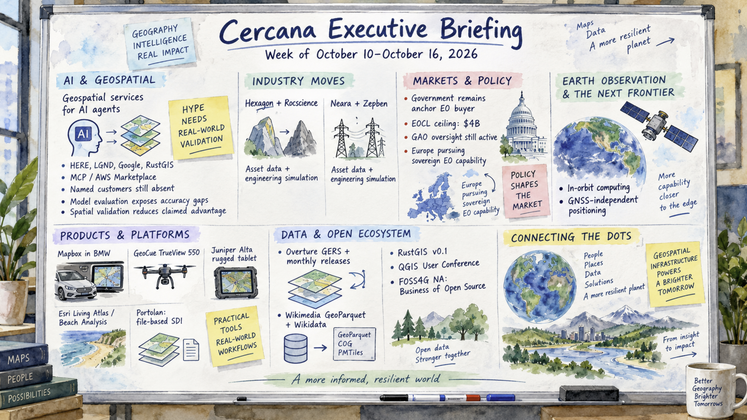
This week’s briefing is delivered in a narrative cartography format. It examines the growing convergence between geospatial technology and general-purpose AI agents, as HERE, Google, LGND, and RustGIS introduce new ways to make spatial capabilities accessible through AI tools. Acquisitions by Hexagon and Neara highlight continued interest in combining asset data with predictive engineering models, while government procurement remains central to the Earth observation market, particularly as European institutions pursue sovereign capabilities. Research on geospatial model evaluation raises questions about reported accuracy and the importance of spatially rigorous validation. Elsewhere, file-based spatial data infrastructure continues to mature, with projects such as Portolan and Overture advancing new approaches to publishing and managing geospatial data. Across these developments, the distinction between emerging technical capabilities and demonstrated market adoption remains an important consideration.
Executive Summary | Cercana Executive Briefing
The most consequential development this week is the emergence of geospatial services designed for general-purpose AI agents. HERE made its Location Reasoning service available through AWS Marketplace as a pay-as-you-go Model Context Protocol (MCP) server, while LGND, Google, and RustGIS introduced similar access to imagery, reasoning, and analysis capabilities. These independent efforts point toward a common distribution model, although availability varies and customer adoption remains unreported. Meanwhile, research on spatial model evaluation highlighted persistent accuracy problems, including an embedding approach whose reported advantage largely disappeared under more rigorous spatial validation.
A second development concerns the integration of asset data with engineering simulation. Hexagon’s agreement to acquire Rocscience and Neara’s acquisition of Zepben both combine live or modelled asset data with engineering simulation, in geotechnical and electrical networks, respectively. Two undisclosed-price deals in different segments don’t establish a trend, but they share a clear product rationale.
Government remained the anchor buyer in Earth observation, with renewed attention to U.S. commercial imagery acquisition oversight and several European sovereign-capability initiatives. The next useful indicators will be named customers and usage data for the agent-access offerings, along with disclosed terms or subsequent transactions in infrastructure software.
HERE makes location reasoning callable
HERE is making its Location Reasoning service available through AWS Marketplace on pay-as-you-go terms, as a Kiro Power, and through Wherobots. Running as a Model Context Protocol (MCP) server on Amazon Bedrock AgentCore, it exposes routing, geocoding, traffic, and place search to AI agents. The significance is less the individual functions, which have existed for years, than the ability to call them from assistants without opening a dedicated GIS interface. Pricing and distribution are visible, but named production customers and usage volumes have not been disclosed.
LGND links satellite imagery to AI assistants
TerraWatch reported that LGND introduced a tool connecting Sentinel-2 and NAIP imagery to ChatGPT and Claude. The release is one of several independent efforts to make geospatial data accessible through general-purpose AI assistants rather than a specialized GIS interface. The briefing identifies the distribution approach as noteworthy, but doesn’t report production customers, usage volumes, or evidence of adoption for this offering.
Google expands geospatial reasoning access
Google is expanding limited early access to its Geospatial Reasoning Agent through an agent-to-agent API, according to Spectral Reflectance. This is another example of spatial reasoning capabilities being offered to other agents instead of solely through a conventional GIS application. Access remains limited, and no customer or usage figures were reported. It is therefore more useful as evidence of an emerging technical distribution approach than as evidence of established demand.
RustGIS introduces a desktop GIS with MCP
Qiusheng Wu released RustGIS v0.1 under the Apache-2.0 license in the opengeos GitHub organization. The application runs natively on three desktop platforms and in a browser, integrates Whitebox and GeoLibre tools, and includes an MCP server. MappingGIS, geoObserver, and Paul Shapley covered the release within days. The project was reportedly developed largely with AI coding assistance, but it currently has a single maintainer. It may make certain workflows more accessible without yet approaching the maturity or breadth of QGIS or ArcGIS Pro.
Hexagon agrees to acquire Rocscience
Hexagon signed an agreement to acquire Toronto-based Rocscience from TA Associates and its founders. Rocscience supplies geotechnical analysis software to mining, civil engineering, and energy customers in approximately 125 countries. The business is expected to join Hexagon’s Radar & Monitoring division, where monitoring observations could help calibrate ground-behaviour models. The combination connects measurements of physical assets with simulation of how they may behave. Neither the purchase price nor the closing schedule was disclosed, limiting comparisons with other transactions.
Neara acquires electrical network modeller Zepben
Neara acquired Zepben, an Australian company specializing in CIM-based electrical network modelling. The combination is intended to bring physical and electrical digital twins together for utilities, including applications involving data-centre load and distributed-energy forecasting. Like Hexagon’s planned acquisition of Rocscience, the deal extends an asset-focused platform into predictive engineering. Neara reports modelling approximately 10 million assets, although that scale is a vendor figure and has not been independently verified. Financial terms were not disclosed.
Mapbox navigation reaches BMW production vehicles
Mapbox’s 3D Live Navigation now powers BMW Maps with driver assistance in Neue Klasse vehicles. The system overlays live driver-assistance detections on a lane-level map, linking detailed mapping with information collected by the vehicle while driving. Unlike several of the week’s early-stage AI announcements, this is a production deployment. Mapbox did not disclose the geographic markets covered or deployment volumes.
GeoCue releases TrueView 550 lidar mapper
GeoCue released the TrueView 550 aerial lidar mapper, featuring dual 20-megapixel cameras and a wider field of view. The announcement is a hardware product release rather than a reported customer deployment. The briefing did not include pricing, independent performance testing, or adoption figures, so the significance is principally the addition to GeoCue’s mapping equipment lineup.
Juniper Systems launches Alta field tablet
Juniper Systems launched the Alta, a rugged Android tablet with on-device AI capabilities. It was among several field-hardware developments this week emphasizing processing at the edge, closer to where observations are collected. The announcement points to continued attention to field computing, although the briefing does not provide performance benchmarks, procurement figures, or customer deployment details.
Esri updates enterprise content and GEOINT tooling
Esri released new Living Atlas content for ArcGIS Enterprise 2026.2 and a Beach Analysis solution aimed at foundational GEOINT workflows. The updates cover two different parts of the GIS stack: readily available data and a more specific analytical workflow. The briefing records these as product releases, without reporting customer uptake or measurable effects on analyst productivity.
Agricultural estimates move into commodity analytics
Zema Global and SatYield announced an integration bringing SatYield’s estimates of crop yield, acreage, and crop condition for the United States and Brazil into Zema’s commodity analytics platform. The intended audience includes commodity traders and energy-market participants who can incorporate agricultural conditions into existing analysis. Neither financial terms nor performance results were disclosed. It is a concrete example of specialized geospatial-derived estimates being distributed through an established industry workflow.
U.S. commercial GEOINT procurement faces scrutiny
Project Geospatial assembled public oversight records on U.S. commercial GEOINT acquisition. Three of four GAO recommendations dating to 2022 reportedly remained open as of April 2026. The EOCL contracts with BlackSky, Maxar, and Planet have a combined $4 billion ceiling, but that figure is a maximum, not money spent. GAO’s published average annual funding ranges were $200–300 million for commercial electro-optical imagery, $0–50 million for radar, and $0–2 million for hyperspectral. The disparity may matter more to vendors outside electro-optical imagery than the aggregate ceiling. An August 2026 Senate intelligence report also directed NGA and NRO to provide joint quarterly progress reports through FY2027. The analysis relies on public records, not interviews.
Europe studies a sovereign Earth observation service
ESA design studies led by ICEYE and Leonardo are advancing plans for the EU Earth Observation Governmental Service, with service anticipated in 2028. The effort belongs to a broader European push for sovereign Earth observation capability. Its current status matters: design studies can clarify technical options and institutional priorities, but they are not the same as funded, operational procurement. The briefing did not identify disclosed contract values for these studies.
Planet prototypes Slovenia Space Resilience Node
Planet has a 12-month prototype effort for a Slovenian Space Resilience Node, part of a cluster of European sovereign Earth observation developments covered this week. The announcement provides evidence of technical exploration rather than a commitment to an operational service. The distinction between prototype work and enduring procurement remains important when assessing the commercial scale of these initiatives.
Hungary plans a radar-equipped constellation
MetaSensing radar payloads are associated with Hungary’s planned satellite constellation. The project appears alongside several European efforts to develop sovereign Earth observation capabilities, including EU-level studies and national prototypes. The briefing does not report an operational deployment or disclosed contract value for this item, so it is best understood as a planned capability rather than established capacity.
Spain funds wildfire-related space projects
Earth Imaging Journal reported €3 million in co-funding from ESA and the Spanish space agency for eight wildfire-related projects. The awards illustrate continued public investment in space-enabled environmental applications. Spread across eight projects, the funding is modest compared with major operational Earth observation procurements. The briefing did not report deployment results or detailed project-level outcomes.
Calian wins NATO scenario-development contract
Calian received a CAD$47 million, five-year award for scenario development at NATO’s Joint Warfare Centre. It was the largest newly disclosed contract value among the government items captured in this week’s briefing. Unlike the many European studies and prototypes discussed elsewhere, this announcement specifies both a value and a term, although it addresses scenario development rather than the purchase of satellite imagery.
Census distributes 2026 TIGER files
The Census Bureau’s TIGER 2026 files and a shapefile for the 120th Congressional District circulated through ProximityOne. These resources support mapping and analysis of administrative and political boundaries. One practical caveat is that a file’s publication date does not necessarily match the vintage of every boundary it contains. That distinction matters when comparing releases or joining contemporary data to geographic units.
Sri Lankan poverty mapping faces geographic holdout test
The Spatial Edge summarized research by LIRNEasia and Carnegie Mellon covering all 13,985 of Sri Lanka’s smallest administrative units. With resources sufficient to target 25% of areas, machine-learned poverty maps identified 83% of the poorest areas, compared with 45% using a night-lights baseline. The result was less robust when the Northern Province was withheld during training: recall fell to 46%. The contrast illustrates why performance measured across randomly distributed observations may not hold when a model is applied in a geographically distinct area.
Spatial buffering changes forest embedding evaluation
A Cambridge study evaluated 4,825 forest parcels and found that introducing a 10 km spatial buffer during validation sharply reduced one embedding model’s apparent advantage over Sentinel-derived features. The remaining difference, 0.03–0.04 PR-AUC, was statistically insignificant. This result does not establish that embeddings are generally ineffective. It shows that spatial proximity between training and test samples can materially change conclusions about model performance, and that evaluation methods need to reflect intended deployment conditions.
Google moves geospatial embeddings toward services
TerraWatch reported that Google is turning geospatial embeddings into a managed change-monitoring service. Separately, Google’s population foundation-model embeddings are in preview through Maps Platform. GeoSpatial ML also demonstrated browser-only aerial image search using patch embeddings compressed to a few bytes each. Together, these developments suggest movement from research artifacts toward usable services and demonstrations. Their preview status and the absence of reported adoption figures limit conclusions about demand.
Portolan advances object-storage-based SDI
David G. Smith described Portolan, a specification and toolkit for publishing catalogs of GeoParquet, Cloud Optimized GeoTIFF (COG), and PMTiles assets directly from object storage. The approach reduces dependence on a continuously running application server for certain kinds of spatial data publishing. Portolan already has named supporters, municipal contributors, and a QGIS plugin at v0.2, but remains early in development, with breaking changes expected. Adoption by large public data publishers would provide a more substantial indication of production readiness.
Wikimedia Enterprise releases linked GeoParquet data
Wikimedia Enterprise released a GeoParquet dataset linking tens of millions of OpenStreetMap features to Wikidata. The release makes it easier to connect geographic features with the broader structured information maintained in Wikidata, using a format suited to analytical data pipelines. In the same infrastructure discussion, Overture described how GERS identifiers and monthly releases reconcile hundreds of sources. Both developments emphasize the role of stable identifiers and interoperable files in using spatial data across systems.
GeoNode 5.1 improves cataloguing
GeoNode 5.1.0 added support for cataloguing non-spatial datasets and data hosted remotely. The update broadens what can be discovered through a GeoNode catalog without requiring every resource to be a conventional locally hosted spatial dataset. It is a more incremental development than the week’s new AI-facing tools, but illustrates ongoing maintenance and expansion in an established open-source geospatial project.
QGIS community meets in Laax
The QGIS User Conference in Laax drew more than 420 participants from over 30 countries. Anita Graser also introduced QGIS Hub, intended to support sharing packaged layers. Both developments reflect the scale and activity of the established QGIS community, where reusable data packages and opportunities for users to exchange techniques matter alongside new software releases.
FOSS4G North America prepares business track
FOSS4G North America, scheduled for November 2–3 in Sacramento, published a Business of Open Source track covering sustainability, workforce issues, and contributing to GDAL in the era of large language models. The conference also amended its code of conduct to prohibit smart glasses and other non-obvious recording devices. These are different kinds of governance questions: sustaining the people and organizations behind shared software, and establishing expectations for participation at in-person events.
Onboard satellite inference faces practical tests
The briefing flagged two developments in computing and inference aboard satellites. It included a reported October 1 demonstration involving Google’s Project Suncatcher TPUs, although that specific launch claim was not independently verified. Separately, ESA’s Φsat-2 marine detector produced false alarms on its first real images. The latter is a practical reminder that models tested before deployment may behave differently on operational imagery. Published performance results would help distinguish promising demonstrations from reliable onboard analysis.
GNSS-independent positioning draws research attention
Dirac Labs, a University of Wisconsin–Madison spinout, joined the Wisconsin Security Research Consortium. Its appearance in the briefing reflects interest in positioning methods that do not depend on GNSS, particularly as interference and spoofing remain concerns for defence and civilian users. The consortium connection is an early indicator of activity, not proof of a mature procurement market. Funded deployments and additional independent suppliers would provide stronger evidence of sustained demand.