
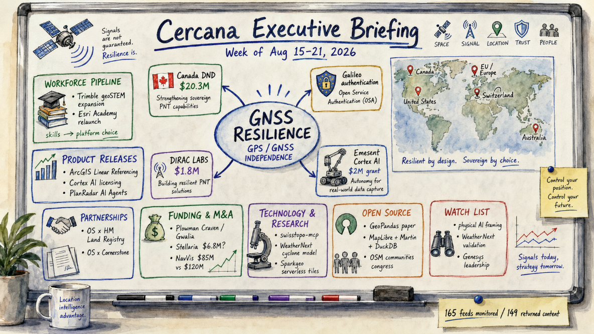
165 feeds monitored. Published August 21, 2026.
Executive Summary
The most interesting pattern this week wasn’t commercial. It was defensive. Four organizations, working independently, all moved to reduce their dependence on GPS and GNSS signals: Canada’s defense ministry funding quantum sensing, the EU hardening Galileo with cryptographic authentication, and two early-stage companies, Dirac Labs and Emesent, building positioning and autonomy technology around the same gap. None of the four is large on its own. Together, in the same week, they’re harder to wave off as coincidence.
A second, quieter pattern showed up in workforce development: Trimble and Esri both published education-focused content within a day of each other. That could be calendar coincidence, since the AGS symposium is coming up, but it also fits a logic worth naming: whoever owns the on-ramp into geospatial skills has some influence over tomorrow’s platform choices.
Everything else stayed fragmented. A UK survey-firm acquisition, two Ordnance Survey data partnerships, a run of Esri product releases, and a NavVis funding figure that doesn’t match the company’s own numbers. None of it added up to something bigger. Earth observation and cloud-native infrastructure, usually reliable sources of weekly signal, went quiet. Worth watching: whether the GNSS-resilience moves draw a second round of procurement, and whether the “physical AI” framing three different vendors reached for this week turns into something more than a shared marketing instinct.
Major Market Signals
Government, Protocol, and Startup Capital Converge on GNSS-Independent Positioning
Four separate developments this week attacked the same problem from different angles: what happens when you can’t trust GPS.
Canada’s Department of National Defence put $20.3M over two years into a University of Calgary-led consortium to build the Quantum Defence Innovation Secure Hub, developing GNSS-independent navigation and anti-spoofing under its BOREALIS program. The EU’s Galileo Signal Authentication Service went live on the E6-C signal, giving civilian users ranging-level authentication for the first time. Meanwhile, US-based Dirac Labs raised $1.8M in pre-seed funding for quantum positioning sensors built for GPS-denied environments, and Australia’s Emesent picked up a $2M grant to commercialize Cortex AI, its GPS-denied autonomy stack, for robotics OEMs.
Four countries, four mechanisms: quantum sensing, cryptographic authentication, startup capital, and licensing, with no shared press cycle to explain it away. It’s possible this is simply the background rate of GNSS-resilience investment now, rather than a spike worth flagging. That’s worth checking against prior months once more data comes in.
Confidence: Medium-High. Watch for a fifth event, a hardware deployment with measurable results, or a major-power defense contract.
Platform Vendors Begin Treating Workforce Pipelines as Competitive Terrain
Trimble and Esri both put out workforce-development content within a day of each other, and it’s worth asking why. In a UBIQUE/AGS Globe interview, Trimble’s Ian Warner talked up the company’s geoSTEM education push ahead of the American Geographical Society’s Geography 2050 symposium, framed explicitly as strategy, not sponsorship. Esri, separately, relaunched Esri Academy with a redesigned learning experience.
Two vendors, same underlying asset: influence over how the next generation of practitioners learns the tools. The less interesting explanation is calendar coincidence. The AGS symposium is close, and academic-year timing nudges this kind of content anyway. This week’s evidence can’t rule that out. But if there’s a real strategy underneath it, training doubles as a retention play: early skills formation can help shape which platforms become the default years later.
Confidence: Medium. Watch for Bentley, Hexagon, or Safe Software making a comparable move, or for enrollment and outcome numbers that would make this more than marketing copy.
Notable Company Activity
Product Releases
- Esri: Released ArcGIS Linear Referencing, a unified product for measure-based enterprise data management, and relaunched Esri Academy with a redesigned learning experience. Both are generally available, with no adoption figures disclosed.
- Emesent: Moved Cortex AI, its GPS-denied autonomy stack, from an internal capability toward commercial licensing for robotics companies and OEMs, backed by the grant noted above.
- PlanRadar: Launched PlanRadar AI Agents, pitched as software that acts on construction-project documentation gaps without waiting for approval. Announced, but not yet independently evaluated in the field.
Partnerships
- Ordnance Survey × HM Land Registry: Announced a data collaboration the UK government says will speed up property transactions, a data-sharing agreement rather than a systems merger.
- Ordnance Survey × Cornerstone: Reported that an existing data-quality partnership has improved asset records across 16,500 telecom sites nationwide, an update on established work rather than a new deal.
Funding & M&A
- Plowman Craven / Gwalia Surveyors: Plowman Craven acquired the smaller Welsh survey practice Gwalia Surveyors to expand into Wales and the South West; consideration was undisclosed.
- Dirac Labs: Closed a $1.8M pre-seed round for quantum positioning sensors (see Major Market Signals).
- Stellaria: The Abu Dhabi-based geospatial AI company reportedly raised $6.8M in seed funding, according to a single newsletter roundup not independently corroborated elsewhere in this week’s feeds.
- NavVis: Spatial Source reported a “$120M” raise “to accelerate its AI roadmap,” but the underlying financing, a Series D led by The Jordan Company with Yttrium, KOZO KEIKAKU ENGINEERING, and Cipio Partners, closed August 6, before this week’s window. NavVis’s own announcement puts the figure at $85M (€73.7M). The gap between the two disclosed figures is unresolved in the available sources; treat the larger number with caution.
Government and Policy Developments
Beyond this week’s GNSS-resilience funding, the clearest policy activity concerned land-administration data rather than new legislation. Ordnance Survey and HM Land Registry announced a collaboration the UK government frames as reducing friction in property transactions, a data-sharing arrangement with implementation details not yet public.
Separately, Ordnance Survey and telecom infrastructure operator Cornerstone reported that their existing asset-data partnership has improved records across 16,500 UK sites, continuing rather than launching that relationship.
In Australia, geospatial data provider Geoscape argued publicly that local councils should receive free access to national location intelligence for infrastructure and hazard management. That’s advocacy for a policy change, not evidence one is underway, but it’s a data point on where pressure for open public geodata access is coming from this month.
Technology and Research Trends
Swiss federal geodata became accessible to AI agents through the Model Context Protocol this week via an independent developer’s swisstopo-mcp server. It bridges 20 tools spanning the Swisstopo REST API, the federal STAC catalog, and the ÖREB/RDPPF cadastre. It extends the Agentic GIS/MCP thread that’s been building since Q2 2026 and suggests national spatial-data infrastructure is becoming a specific integration target rather than merely a talking point.
Elsewhere, EarthStuff highlighted a Google DeepMind claim that its WeatherNext AI model hits state-of-the-art accuracy on cyclone track, intensity, and wind-structure forecasts. That’s a substantive claim, but it reached this week’s feeds through a single curator pointing to DeepMind’s blog and a Nature paper. No independent operational evaluation by a meteorological agency showed up in the corpus this week.
Worth noting separately: Sparkgeo published a detailed account of swapping a PostGIS-based vector-tile server for a serverless AWS Lambda setup backed by SQLite and SpatiaLite. It’s one case study, not a trend, but it’s a concrete data point on how smaller geospatial teams are managing cloud costs.
Open Source Ecosystem Signals
GeoPandas published its canonical paper this week, a peer-reviewed, open-access account of the library’s history and architecture, arriving two years after the 1.0 release it was meant to accompany. That’s a genuine documentation and governance milestone for one of the most widely used libraries in the geospatial Python stack, not just a formality.
Separately, MapLibre’s Google Summer of Code program produced a DuckDB backend for the Martin tile server. Incremental, but real open-source progress.
OpenStreetMap’s blog also recapped its Local Chapters and Communities Congress, a March event with participants from ten countries across Africa, Europe, and the Americas. It’s a useful community-health data point on OSM’s organizational reach, even if the recap itself isn’t new activity.
Watch List
- Spatial data as “physical AI” infrastructure: NavVis’s funding narrative, Emesent’s robotics-OEM licensing move, and PlanRadar’s autonomous-action AI agents all reached for versions of the same framing this week: spatial data as the substrate physical-world AI runs on. Three companies, three different kinds of announcement, so it’s thin so far. It’d move up if a customer discloses real deployment numbers or a fourth vendor picks up the same language. If the framing doesn’t resurface next quarter, it was probably just this week’s shared instinct.
- WeatherNext cyclone model: DeepMind says its WeatherNext model hits state-of-the-art accuracy on cyclone forecasting, but this week’s feeds produced no independent operational evaluation. A meteorological-agency assessment or evidence of operational adoption would change that.
- Genesys International’s leadership transition: The Indian geospatial firm appointed Nikhil Alulkar as CEO with an explicit mandate to scale “AI-native mapping” across enterprise and government markets. That’s a stated intention, not a track record yet. It’s worth revisiting if concrete product launches or contract wins follow in the next month or two, less so if it stays at the announcement stage.
Top Posts of the Week
- Canada launches $20.3M Quantum Defence Hub to develop GNSS-independent navigation, anti-spoofing tech — Earth Imaging Journal — Primary source for the largest single GNSS-resilience commitment this week.
- Galileo Signal Authentication Service underway — Geoconnexion — Confirms the protocol-layer piece of this week’s GNSS-resilience signal.
- Dirac Labs Raises $1.8M to Build a Quantum Universal Positioning System for Defense and Commercial Platforms — Earth Imaging Journal — The startup-capital data point completing the week’s convergence.
- Emesent Secures $2M Grant to Develop GPS-Denied Autonomy Open Platform Cortex AI — Geoconnexion — Ties the GNSS-resilience signal to this week’s “physical AI” watch item.
- MCP server for Swiss federal geodata — Spatialists — The clearest evidence this week that national spatial-data infrastructure is becoming a specific MCP integration target.
Cercana Executive Briefing is generated from 165 feeds aggregated by geofeeds.me.