
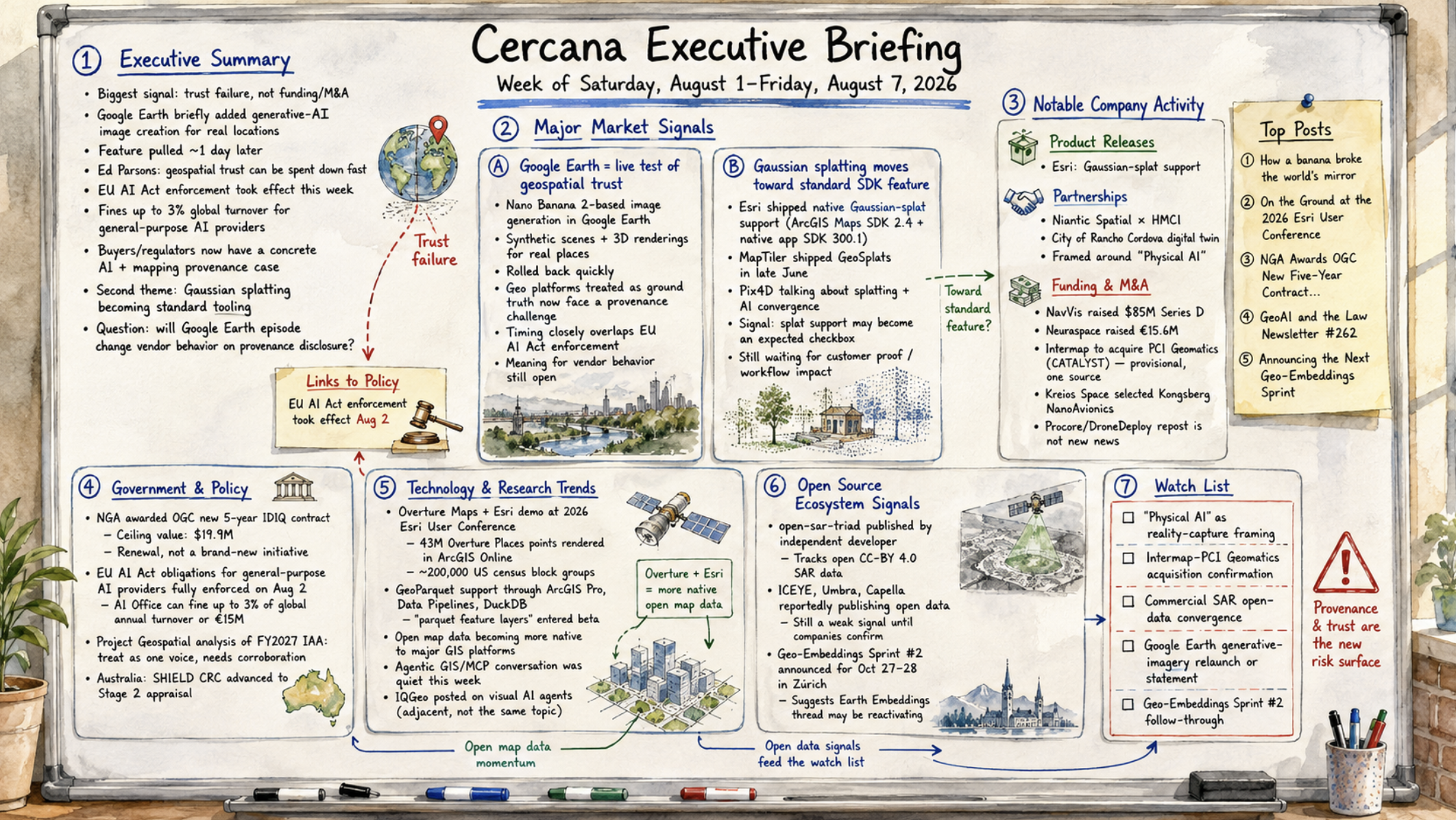
162 feeds monitored. Published Friday, August 7, 2026.
Executive Summary
The biggest news this week wasn’t a funding round or an acquisition. It was a trust failure. Google briefly built generative-AI image creation directly into Google Earth, allowing users to conjure synthetic scenes for real locations, then pulled the feature about a day later. Ed Parsons’s response, that decades of accumulated geospatial trust can be spent down almost instantly, landed the same week the EU AI Act’s enforcement provisions took effect, with fines of up to 3% of global turnover for general-purpose AI providers. Buyers and regulators now have a concrete case study instead of an abstract argument about AI and mapping authority.
A second, quieter thread points in the same direction from a different angle: Esri, MapTiler, and Pix4D have all shipped Gaussian-splat capture or support into customer-facing products since June, and splatting’s starting to look more like standard tooling than a conference demo.
Company activity was busy without adding up to much on its own. There were separate funding and acquisition stories in reality capture, space-domain awareness, and EO consolidation, but none was large enough to define the week. Government activity was mostly procedural, led by a renewed five-year NGA–OGC standards contract and continued EU AI Act rollout.
The open question is whether the Google Earth episode changes vendor behavior on provenance disclosure or simply fades as a one-week story. Given the AI Act’s new enforcement powers, the former looks more plausible than it would’ve a month ago.
Major Market Signals
A Generative-AI Feature Inside Google Earth Becomes This Cycle’s Live Test of Geospatial Trust
Google added an AI image-generation capability, built on its Nano Banana 2 model, directly into Google Earth in the final days of July, allowing users to prompt synthetic scenes and 3D renderings for real locations. It then disabled the feature again within roughly a day.
The reaction was immediate and came from several directions. Ed Parsons, writing on his own blog, framed the episode as a breach of an unwritten rule that Google’s Geo organization spent decades establishing: that Earth and Maps were a “mirror of the real world.” Spatialists surfaced OSINT investigator Henk van Ess’s critique of blending generative and authoritative imagery at consumer scale. Strategic Geospatial documented the rollback happening in real time, mid-draft.
None of this proves Google was responding to criticism rather than routine feature-flag testing. The company hasn’t said why it pulled the feature, and that matters before reading too much intent into the reversal.
What’s not in doubt is the timing. GeoAI and the Law tied the episode directly to the EU AI Act’s general-purpose-AI obligations, which reached full enforcement on August 2, two days later. Any organization that treats EO or mapping platforms as ground truth now has a concrete provenance failure to point to. It arrived just as the regulatory cost of getting this wrong increased.
That’s about as solid as this week’s evidence gets. What it means for vendor behavior six months from now remains genuinely open.
Gaussian Splatting Moves From Conference Demo Toward Standard SDK Feature
Esri shipped native Gaussian-splat support across ArcGIS Maps SDK 2.4 for Unreal Engine and Unity on August 5, along with splat layers in its native-app SDK 300.1, confirmed on Esri’s own blog.
That makes three independent vendors productizing the same reconstruction technique inside customer-facing tools in about six weeks. MapTiler shipped its commercial GeoSplats product in late June, while Pix4D’s CTO reframed the company around the convergence of splatting and AI in a July interview with xyHt.
A GIS-platform incumbent, a basemap vendor, and a photogrammetry vendor don’t usually move in step. That’s what makes this worth flagging rather than treating each release as vendor-specific. Esri may simply be advancing its XR roadmap, MapTiler may be differentiating its basemap, and Pix4D may be repositioning around reality capture, with no shared cause at all.
Nothing here proves a broader market shift yet. But it does suggest splat support is on its way to becoming a checkbox buyers expect rather than a feature they pay extra for. There still isn’t a customer case study or measurable workflow gain in the feeds to confirm that. Worth watching for a fourth vendor, or the first customer story showing that a splat layer materially changed how a job got done.
Notable Company Activity
Product Releases
- Esri: Shipped ArcGIS Maps SDK 2.4 for Unreal Engine and Unity, plus SDK 300.1 for native apps, all adding Gaussian-splat layer support (see Major Market Signals).
Partnerships
- Niantic Spatial × HMCI: Building the data foundation for what the companies call the City of Rancho Cordova’s first digital twin. This is a public-sector deployment rather than a commercial integration, and it’s explicitly pitched around “Physical AI.”
Funding & M&A
- NavVis raised an $85M Series D led by The Jordan Company, with existing shareholders Yttrium, KOZO KEIKAKU ENGINEERING, and Cipio Partners participating. The company is pitching the funding around what it calls a “spatial data engine.” That’s the same Physical AI framing used in Niantic Spatial’s deal above, and both appeared on the same day.
- Neuraspace raised €15.6M, blending Portuguese state recovery funds with private VC, to scale AI-driven space-domain awareness and defense-grade space traffic management.
- Intermap Technologies entered a definitive agreement to acquire PCI Geomatics (CATALYST), pairing Intermap’s proprietary 3D elevation data with PCI’s image-processing IP under a Canada Business Corporations Act arrangement. One source only, Earth Imaging Journal, so treat the details as provisional until something else confirms them.
- Kreios Space selected Kongsberg NanoAvionics to build what the companies describe as the first air-breathing electric-propulsion satellite bound for very-low-Earth orbit.
- One item isn’t new: a “Procore to acquire DroneDeploy” story recirculated this week via Earth Imaging Journal on August 5. The deal was announced July 29 and already covered in last week’s briefing at a reported ~$845M. No new facts came with this week’s repost, so it doesn’t count as this week’s news, however many times it appears in the feeds.
Government and Policy Developments
The National Geospatial-Intelligence Agency awarded the Open Geospatial Consortium a new five-year IDIQ contract with a ceiling value of $19.9M. Awarded July 16 and publicized this week, it succeeds the vehicle the two organizations ran from 2021 through 2026. The contract gives other federal agencies a faster path to fund OGC membership and sponsor standards work. It isn’t a new initiative, just an existing one renewed with a disclosed number attached.
The EU AI Act’s obligations for general-purpose AI providers reached full enforcement on August 2. The AI Office can now fine providers up to 3% of global annual turnover or €15M for gaps in model documentation, training-data summaries, or copyright policy. That lands directly on geospatial foundation-model providers, and the timing alongside the Google Earth episode is hard to ignore.
Project Geospatial published a long analysis of the proposed FY2027 Intelligence Authorization Act and the tension it creates between commercial EO transparency and operational security. Nobody else covered it this week. Project Geospatial’s framing has carried a standing calibration note in this publication for some time: hyperbolic register, needs corroboration. The underlying legislative development is real, but the analysis itself should be treated as one voice’s interpretation until something independent backs it up.
In Australia, a bid for a national Positioning, Navigation and Timing research centre, SHIELD CRC, advanced to Stage 2 appraisal. Small, but it continues the sovereignty/PNT thread this publication has tracked since February.
Technology and Research Trends
Overture Maps Foundation published its account of a joint demonstration with Esri at the 2026 Esri User Conference. The demonstration included an Overture Places layer rendering 43 million points live in ArcGIS Online against roughly 200,000 US census block groups; GeoParquet support running through ArcGIS Pro, Data Pipelines, and DuckDB workflows; and a new “parquet feature layers” ArcGIS Online layer type that entered beta just before the conference.
Worth flagging that this remains a single-source account of Esri’s own roadmap. Nothing matching it appeared on Esri’s blog this week. But if it holds up, open map data’s becoming native to the dominant proprietary GIS platform rather than living at the edges as a plug-in.
The Agentic GIS/MCP conversation, one of the busiest technical threads of Q2, was quiet this week. The one exception was an IQGeo vendor post on “visual AI agents” for telecom and utility networks. It’s adjacent to, but not really part of, the same conversation because it focuses on visual inspection agents rather than MCP integration.
Open Source Ecosystem Signals
An independent developer with no vendor backing built and published open-sar-triad, a small tool for discovering the open CC-BY 4.0 SAR data that three competing commercial operators, ICEYE, Umbra, and Capella, reportedly now publish.
It’s a personal post, not a primary source or independent reporting, so the underlying claim about three simultaneous open-data programs remains a weak signal until one of those companies confirms it directly.
Just before this week’s window opened, on July 29, Cloud Native Geo, IBM, Clark University, and Planet announced a second Geo-Embeddings Sprint for October 27–28 in Zürich. It’s the first real evidence that the Earth Embeddings sub-theme, quiet since the first sprint’s writeup in April, is returning rather than fading out.
The announcement falls a couple of days outside the strict Saturday–Friday window, so it’s noted here rather than counted as this week’s news. But it answers a standing watch condition from prior briefings and is reflected in this week’s landscape-context update.
Watch List
- “Physical AI” as reality-capture framing: NavVis’s Series D and the Niantic Spatial/HMCI digital twin partnership both leaned on “Physical AI” as customer-facing language on the same day and through the same publisher. Promote if a third independent vendor adopts the term or a customer names a real use case. Drop it if nobody says it again next month.
- Intermap–PCI Geomatics acquisition: One feed so far. Promote once a second independent source or a joint press release appears.
- Commercial SAR open-data convergence: The open-sar-triad claim that ICEYE, Umbra, and Capella all now run CC-BY 4.0 open-data programs needs confirmation from one of those companies before it becomes an established pattern rather than one developer’s read of the situation.
- Google Earth generative-imagery feature: Watch for a relaunch with visible synthetic-content labeling, or any statement from Google explaining why it pulled the feature. Either would change how this week’s trust story reads in hindsight.
- Geo-Embeddings Sprint #2, Zürich, October 27–28: Watch the community-meeting cadence between now and October. Some prior CNG series have drawn a strong crowd once and then gone quiet again. This needs to show follow-through to count as a real reactivation.
Top Posts of the Week
- How a banana broke the world’s mirror — Ed Parsons — The most substantive primary framing of the week’s dominant trust story, from a former Google Geo team member.
- On the Ground at the 2026 Esri User Conference — Overture Maps Foundation — Primary account of GeoParquet and Overture data becoming native to ArcGIS Online.
- NGA Awards OGC New Five-Year Contract to Accelerate Federal Geospatial Standards Collaboration — Open Geospatial Consortium — Primary government-contract announcement with disclosed terms.
- GeoAI and the Law Newsletter #262 — GeoAI and the Law — Ties EU AI Act enforcement directly to geospatial AI providers, the regulatory backdrop for the week’s Google Earth story.
- Announcing the Next Geo-Embeddings Sprint — Cloud Native Geo — Primary confirmation that the Earth Embeddings thread is resuming after a quiet spring.
Cercana Executive Briefing is generated from 162 feeds aggregated by geofeeds.me.