
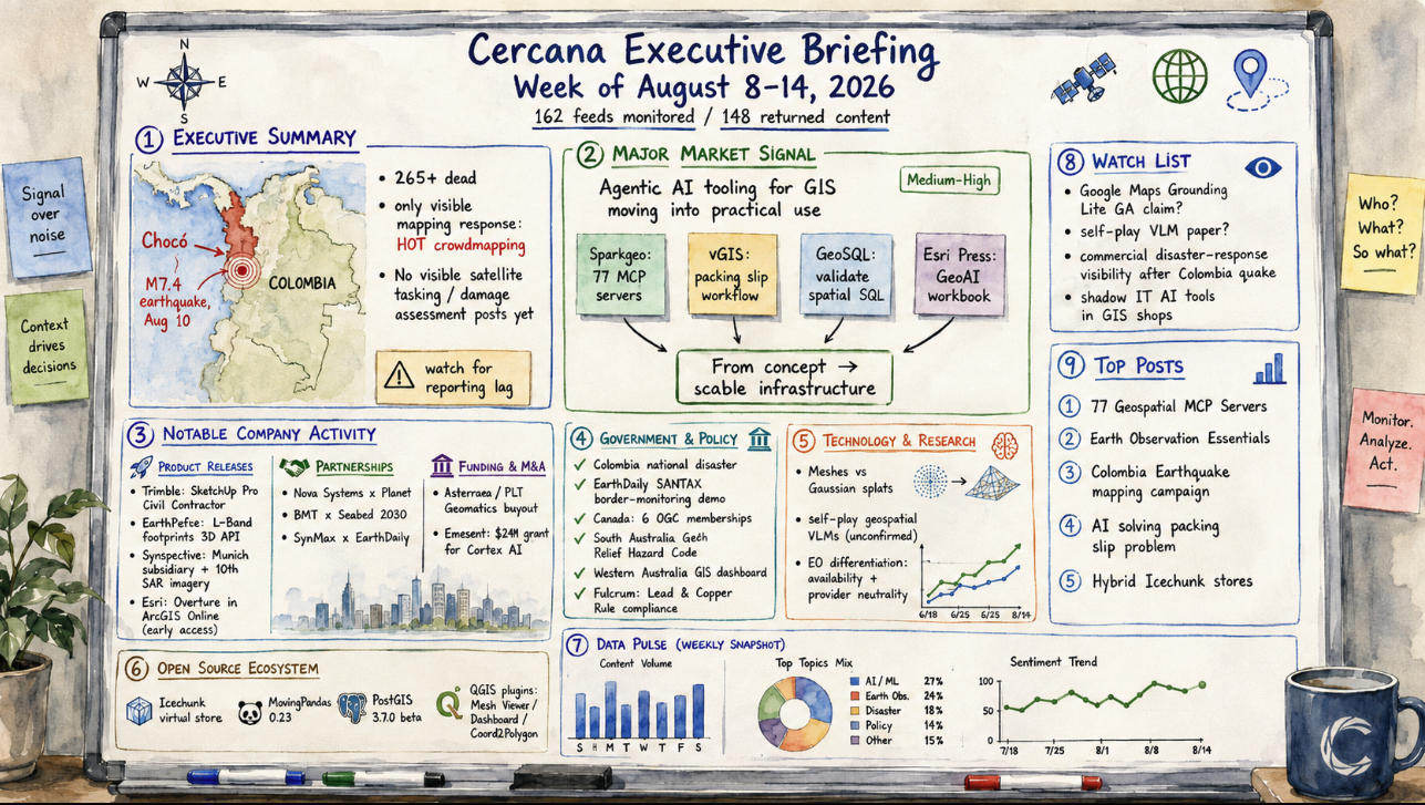
162 feeds monitored. Published August 14, 2026.
Executive Summary
The week’s most consequential development wasn’t a deal, product launch, or funding round, but an absence. A magnitude-7.4 earthquake struck Colombia’s Chocó department on August 10, killing more than 265 people and injuring thousands. By Friday, the only mapping response visible across the 162 monitored geospatial feeds was a single Humanitarian OpenStreetMap Team crowdmapping campaign. No satellite-tasking, damage-assessment, or emergency-management posts from commercial or institutional providers appeared in the tracked corpus during the four days after the quake. That may reflect normal reporting lag rather than an actual absence of response, but the gap is worth watching.
Elsewhere, the clearest cross-company pattern was AI agent tooling for geospatial work moving from concept toward usable infrastructure. A public registry of Model Context Protocol servers, a production case study, an independent validation tool, and a new practitioner-facing book arrived from separate organizations within three days. Earth observation’s recent consolidation wave produced no fresh transactions this week; the deals still circulating in trade coverage were announced in late July. Company activity instead concentrated around defense-adjacent partnerships, open-source tooling releases, and one contested claim about a Google Maps AI feature reaching general availability that this survey couldn’t independently confirm.
Major Market Signals
Agentic AI Tooling for GIS Is Moving Into Practical Use
Confidence: Medium-High. Four independent organizations produced evidence this week that AI-agent tooling is beginning to move into working geospatial use rather than remaining primarily conceptual. Sparkgeo published a public registry cataloging 77 Model Context Protocol (MCP) servers across ten categories, including geocoding, routing, STAC catalogs, imagery, and desktop GIS. The registry is generated programmatically from a single source file rather than maintained by hand.
Separately, vGIS described a production system that uses AI to reconcile construction packing slips against purchase orders, a narrow but concrete three-way-matching workflow. An independent developer released GeoSQL, which allows an AI agent to validate its own spatial SQL against real geometry before execution. Esri Press published a new ArcGIS-oriented GeoAI workbook.
These are different mechanisms — a registry, a deployed workflow, a validation tool, and a publication — from unrelated organizations. Together, they support treating the activity as more than one company’s press cycle. The alternative explanation is that “agentic AI” is simply a fashionable label being applied across unrelated projects that would’ve happened anyway. Nothing here yet demonstrates broad customer adoption. A second wave of vendor case studies with measurable outcomes, or continued growth in the registry’s server count, would strengthen the signal.
Notable Company Activity
Product Releases
- Trimble: Launched SketchUp Pro Civil Contractor, connecting 3D modeling with its Siteworks positioning system for field layout and earthmoving on civil projects.
- EarthDefine: Launched a Buildings Footprints 3D API providing structure-level geospatial data to developers.
- Synspective: Opened a new European subsidiary in Munich and separately released first imagery from its 10th SAR satellite — two distinct developments in the same week, one commercial expansion and one constellation milestone.
- Esri: Moved Overture Maps data into ArcGIS Online as Parquet feature layers, in early access rather than general release.
Partnerships
- Nova Systems × Planet: Announced a partnership aimed at supporting Australian Defence Force and national intelligence situational awareness. Terms and scope beyond “partner” weren’t disclosed.
- BMT × Seabed 2030: BMT will contribute survey capacity to the Seabed 2030 ocean-floor mapping initiative across Asia-Pacific.
- SynMax × EarthDaily: SynMax integrated EarthDaily’s AI-ready imagery into its maritime intelligence platform.
Funding & M&A
- Intermap Technologies / PCI Geomatics: Trade coverage this week reported Intermap’s move to buy out the remaining minority stake in PCI Geomatics that it doesn’t already own for $11 million in cash. The agreement was originally announced July 28, so this is continued coverage rather than a new transaction.
- Emesent: Secured a $2 million grant from an Australian government research-commercialization program to develop Cortex AI, a commercial version of its GPS-denied autonomy stack for robotics OEMs.
Government and Policy Developments
The Colombia earthquake is this week’s most significant public-sector development, even though the geospatial industry’s visible role remained limited to volunteer crowdmapping. Colombia’s government declared a national disaster and directed search-and-rescue operations. Whether commercial satellite tasking, Copernicus Emergency Management Service activation, or damage-assessment contracts followed isn’t yet visible in the survey’s sources. Vendor disaster-response announcements often lag events by days or weeks, so this is something to track rather than draw a conclusion from.
On procurement, EarthDaily was awarded a Canadian government contract to develop an AI-enabled border-monitoring demonstration platform under the SMATAK project. It’s an early-stage exploratory award rather than an operational deployment. Canada’s Natural Resources ministry also opened sponsorship of six OGC memberships for Canadian applicants, with applications closing September 4 — a modest but concrete government investment in standards participation.
In Australia, South Australia opened public feedback on a draft Flood Hazard Code updating flood-mapping and planning rules, while Western Australia published a dashboard mapping H5 bird-flu detections for producers and wildlife carers. In the United States, Fulcrum’s review of water utilities’ compliance with the 2024 Lead and Copper Rule Revisions noted that utilities defaulting uncertain pipe materials to “unknown” are still absorbing the cost, ahead of a tougher baseline-inventory requirement taking effect in November 2027.
Technology and Research Trends
Esri published a comparison of meshes and Gaussian splats as reality-capture representations for 3D GIS, framing them as complementary rather than competing. It’s a useful marker of how quickly Gaussian splatting is entering mainstream GIS vocabulary, although one vendor blog post doesn’t establish adoption.
A newsletter aggregator also flagged a self-play training approach for teaching vision-language models geospatial reasoning without human-labeled data. The underlying paper wasn’t independently identified in the survey’s sources, so this remains an early, unconfirmed signal rather than a research result.
TerraWatch Space’s newsletter argued that as revisit rates and resolution commoditize across Earth observation constellations, continuous data availability and provider neutrality — freedom from a single government’s ability to restrict access — are becoming more important market differentiators. The argument was illustrated by Planet’s release of previously withheld Iranian imagery. This is one analyst’s interpretive framework rather than a confirmed market shift, and its anchor example predates this week.
Open Source Ecosystem Signals
Several open-source geospatial projects advanced independently this week, with no apparent coordination between them. The Cloud Native Geospatial Forum described hybrid Icechunk-based virtual stores that allow NOAA NetCDF snowpack data to render directly in a web map without a separate tile-serving step. MovingPandas released version 0.23, adding Fréchet distance, dynamic time warping, and LCSS trajectory-comparison functions — capabilities many GIS stacks still handle through custom scripts. PostGIS shipped a 3.7.0 beta.
In the QGIS plugin ecosystem, a new Magic Wand plugin generates polygons directly from the map canvas, a practitioner-highlighted Dashboard plugin adds cross-filtering, and a Coord2Polygon plugin flagged earlier in the week generates geometry from coordinate lists.
None of these releases individually changes the competitive landscape. Taken together, however, they show an open-source ecosystem that’s continuing to close specific capability gaps across cloud-native data access, trajectory analysis, spatial databases, and desktop workflows rather than coalescing around any single new capability.
Watch List
- Google Maps Grounding Lite “GA” claim: A Google Maps Platform reseller’s blog described the AI-grounding feature as reaching general availability this week. Google’s own developer documentation and a partner newsletter from earlier this year described it as experimental or pre-GA. Promote this to a confirmed signal if Google’s own channels state GA status directly; drop it if the reseller’s post proves to be premature marketing language.
- Self-play training for geospatial vision-language models: A single newsletter mention describes a self-training approach requiring no human labels. Promote if the underlying paper is identified and shows results replicated or cited elsewhere; otherwise, this remains an unconfirmed pointer.
- Commercial disaster-response visibility after the Colombia earthquake: No satellite-tasking or damage-assessment posts from commercial or institutional EO providers appeared in tracked feeds through Friday. Promote to a market signal if such posts surface with a lag in the coming week; drop the observation if it turns out to reflect normal publication delay rather than an actual gap in response.
- “Shadow IT” AI tool-building inside GIS shops: One practitioner argued that GIS teams are already building internal AI tools the way marketing and finance teams have, without formal governance. This is a single person’s observation. Promote if survey data or multiple independent organizational accounts corroborate the pattern.
Top Posts of the Week
- 77 Geospatial MCP Servers, Mapped and Categorized — Sparkgeo — Primary source for the week’s clearest cross-company signal on agentic AI tooling in GIS.
- Earth Observation Essentials: August 11, 2026 — TerraWatch Space — Analyst framework on availability and neutrality as emerging differentiators in the EO market.
- Colombia Earthquake 2026 mapping campaign — Missing Maps / HOT — The only visible geospatial-industry response to the week’s most significant disaster.
- AI Is Finally Solving Construction’s Packing Slip Problem — vGIS — Vendor case study showing a deployed rather than merely demonstrated AI-agent workflow.
- Hybrid Icechunk stores for serverless web mapping — Cloud Native Geospatial Forum — Primary technical source for this week’s open-source cloud-native format progress.
The Cercana Executive Briefing draws on 162 feeds aggregated by geofeeds.me.