
166 feeds monitored. Published August 28, 2026.
Executive Summary
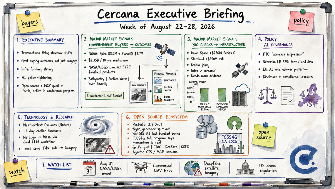
Headline transactions were thin; market structure wasn’t. The most consequential thread was administrative, not commercial: NOAA and NASA/USGS each moved toward buying Earth observation as a finished product rather than raw data, a shift that’s been building for months but crystallized in two parallel disclosures.
Two large infrastructure raises told a related story. Muon Space closed a $250M Series C, and Starcloud extended its round by $250M with Nvidia joining in. Neither company builds imaging satellites, suggesting that late-stage capital still has an appetite for the picks-and-shovels layer of the space economy. Nvidia’s involvement muddies a clean EO reading, though.
On policy, one newsletter tied together three jurisdictions: an FTC proposal on AI “accuracy suppression,” a new Nebraska farm-data law, and EU whistleblower protections that took effect August 2. Together, they offer a genuinely useful, if analyst-mediated, picture of tightening AI governance for GeoAI vendors.
Two threads that dominated recent months, open-source infrastructure and agentic GIS/MCP, went quiet. So did most commercial-vertical coverage, apart from one EarthDaily-insurer wildfire deal. Watch the August 31 NASA/USGS industry event and next week’s Commercial UAV Expo for whether any of these policy and procurement signals turn into something more concrete.
Major Market Signals
Government Buyers Move From Purchasing Imagery to Purchasing Outcomes
Two federal agencies moved to restructure how they buy Earth observation. NOAA awarded contracts to Spire Global ($3.7M) and PlanetiQ ($2.7M) for radio-occultation weather data while working toward a new procurement mechanism that would allow up to $2.35B in data purchases over ten years.
NASA and USGS, ahead of an August 31 industry event, previewed something similar for Landsat: companies, not USGS, would produce finished FY27 products such as bathymetry, surface water extent, and burned-area severity using whatever combination of satellites gets the job done. The deliverable shifts from “imagery” to “spec-compliant product.”
Put the two together and the direction is similar: agencies are defining the requirement, not the sensor. That opens bidding to companies with no satellites of their own and puts more emphasis on cross-sensor calibration.
Maybe that’s overreading it, though. NOAA’s commercial data program and the Landsat commercialization debate have each run on their own multi-year timelines, and it’s entirely possible these are two unrelated processes that happened to align. Worth noting, too, that both facts here come through one analyst (TerraWatch) reading two separate primary documents. Real corroboration would mean a second source independently confirming the framing.
Still, for buyers and vendors, the implication holds either way: owning a satellite matters less than being able to deliver a calibrated, standards-compliant product from whatever happens to be overhead.
The Big Checks Went to EO-Adjacent Infrastructure, Not New Sensors
Muon Space closed a $250M Series C, pushing its total funding past $386M. Starcloud added a $250M extension to its orbital-data-center round, with Nvidia among the new backers.
Neither company builds imaging satellites. Muon manufactures spacecraft for others, while Starcloud sells orbital compute, which is what makes the pairing interesting. Two of the largest checks in this feed set went to infrastructure the EO industry can use, not to new sensors.
Read generously, that fits a market where raw imagery keeps getting cheaper and the surrounding stack doesn’t. Read skeptically, it’s probably not about EO at all. Nvidia backing Starcloud looks at least as much about orbital compute economics as Earth observation demand, and Muon’s manufacturing business isn’t EO-exclusive either.
Two unrelated raises don’t make a trend by themselves. It firms up if the next few weeks keep favoring infrastructure over sensor constellations, and it falls apart if the next big rounds go to imaging satellites or downstream analytics instead.
Notable Company Activity
Product Releases
- Esri / Airbus: Expanded the World Imagery basemap with new high-resolution coverage across roughly 2,000 cities worldwide, part of a broader expansion first announced at this year’s Esri User Conference.
- Indonesian government: Launched Piksel, a national open platform for analyzing analysis-ready Earth observation data, a sovereign counterpart to the commercial basemap expansions shipping alongside it.
- PlanningMapsUK: Launched an online Ordnance Survey platform that lets UK homeowners, architects, and property professionals generate licensed site plans and CAD mapping in-browser.
- FlyGuys: Rebranded its internal reality-capture software as FlyGuys Capture, positioning the company as a technology vendor rather than only a capture-services provider.
- Kongsberg NanoAvionics: Debuted a 500kg, ITAR-free Gen-2 MP42D microsatellite bus for defense-adjacent optical missions, with early customers including Satlantis and SuperSharp.
Partnerships
- EarthDaily × unnamed North American insurance major: Expanded AI-powered wildfire risk intelligence, built on EarthDaily’s FLAIM model, into underwriting and portfolio management across the western U.S. Demand-side insurance deployments are rare in this feed set, which is exactly why this one is worth flagging.
- Leaf Space: Opened its first Canadian ground station at Spaceport Nova Scotia, extending its satellite-communications network.
Funding & M&A
- Muon Space: Closed a $250M Series C, bringing total funding to more than $386M.
- Starcloud: Raised a $250M extension to its orbital-data-center round, with Nvidia participating; total raised is now roughly $420M.
No acquisitions turned up in the search, a genuinely quiet stretch for M&A rather than a gap in coverage.
Government and Policy Developments
The procurement shift above wasn’t the only policy news. AI governance surfaced too, though almost entirely through one specialist newsletter, GeoAI and the Law, tying together three jurisdictions.
The FTC’s proposed policy on “suppression of accuracy” in AI systems holds that a vendor tuning outputs away from what users expect, even to comply with a state law, may be deceiving customers under Section 5 of the FTC Act. For GeoAI vendors, that means restricted or tuned outputs may need meaningful disclosure in product documentation rather than a line buried in the terms of service.
Nebraska’s new Agricultural Data Privacy Act (LB 525) gives farmers ownership of “land data,” which explicitly includes geospatial parcel information, though whether third-party satellite imagery of a farm actually counts as the farmer’s “land data” is genuinely unclear from the statute’s text.
The EU AI Office’s whistleblower channel, now backed by full anti-retaliation protection as of August 2, gives the AI Act’s general-purpose-model rules an enforcement mechanism that geospatial foundation-model vendors selling into the EU will need to account for internally.
These are three separate instruments in three separate jurisdictions, not one coordinated push, and the coverage here is one analyst’s synthesis rather than three independent reports.
Commercial UAV Expo organizers, previewing next week’s Las Vegas show, framed the U.S. drone market as being reshaped by new tariffs, an FCC Covered List overhaul, and a pending Part 108 rule. That’s the event talking about itself, though, not independent reporting. Treat it as a preview of what to check, not confirmation of what changed.
Canada’s sovereignty thread, a fixture in this ecosystem, kept ticking along at modest scale. Calgary opened a $20.3M Quantum Defence Hub aimed at GPS vulnerabilities, EarthDaily is set to test AI-enabled satellite border monitoring for Canada, and a drone-mapping project reportedly supports digital-sovereignty work for the Montreal Lake Cree Nation.
Project Geospatial also published a long analysis of the White House’s 2026 National Security Science and Technology Strategy. The strategy document itself is real. Project Geospatial’s take on what it means for geospatial specifically gets the standing calibration note this source has earned. Treat it as one analyst’s interpretation until something corroborates it.
Technology and Research Trends
The geospatial-AI research leaned operational rather than speculative. Google’s WeatherNext Cyclones, published in Nature, forecasts tropical-cyclone track, intensity, and size about a day earlier than prior models, a real, peer-reviewed gain rather than a benchmark score or demo.
On the academic side, a team used a dual-LLM supervised workflow to rebuild an existing NetLogo agent-based model in Mesa, presented at the 2026 Social Simulation Conference. It’s narrow, but model replication has been a genuine weak spot in that field, so even a small proof of concept is worth flagging.
One newsletter also mentioned, in passing and without detail, that nearly a third of recently published foundation models ship code without the weights. That’s a real reproducibility problem if it holds up, but this briefing only has the headline claim, not the underlying data. Treat it as a lead rather than a finding.
The bigger structural conversation was about trust, not capability. Spatial Reserves revisited the “faked satellite imagery” problem, GAN-generated scenes that are, per the piece, now nearly indistinguishable from the real thing, and argued that skepticism toward mapped data isn’t optional anymore.
That’s a related but different claim from the FTC’s accuracy-suppression policy above. One is about outsiders fabricating imagery; the other is about vendors quietly tuning their own legitimate outputs. Neither has produced anything concrete yet, such as verification tooling or a vendor policy, but both are worth watching to see whether they do.
Open Source Ecosystem Signals
PostGIS shipped 3.7.0rc1, a release candidate built against PostgreSQL 19 Beta 3 and GEOS 3.15.0rc1. The interesting part isn’t the version bump. It’s that postgis_tiger_geocoder, the Census TIGER-based geocoder, is now fully spun out as its own independently versioned extension; 2025.2 shipped a day earlier. PostGIS 3.6 is the last core series that bundles it.
Nothing dramatic here, just an established project doing routine release engineering. But if you maintain a PostGIS geocoding pipeline, the split is the thing to actually check before upgrading.
Outside PostGIS, two threads that have carried this ecosystem for months went quiet in this week’s coverage. Cloud-native infrastructure, including GeoParquet, STAC, and Zarr, produced no new standards or tooling news, and Agentic GIS/MCP, active as recently as June, didn’t surface either. That looks more like a news-cycle lull than a loss of momentum. The now-published FOSS4G North America program is heavy on both, with GeoParquet, STAC, GeoZarr, COPC, and cloud-native data pipelines appearing throughout the schedule alongside multiple sessions on geospatial agents and MCP. The quiet stretch is most likely attributable to the gap between the summer conference cycle and FOSS4G NA.
Watch List
- US drone regulatory turning point: Commercial UAV Expo framed next week’s show around new tariffs, an FCC Covered List overhaul, and a pending Part 108 rule, but that’s the event talking about itself rather than independent reporting on what actually changed. Promote if the show surfaces concrete rule details; drop if it turns out to be routine conference framing.
- Synthetic/deepfake satellite imagery as a live concern: Spatial Reserves’ revisit of GAN-generated fake imagery is one opinion piece, not new technical evidence. Promote if a vendor, standards body, or customer publishes verification tooling or a provenance policy in response.
- Basemap and EO-platform access broadening in parallel: Indonesia’s Piksel platform, Esri/Airbus’s basemap expansion, and PlanningMapsUK’s reseller product all shipped access-broadening infrastructure through three different mechanisms. That’s why this isn’t a Major Market Signal yet: the mechanisms differ too much to call it one convergence. Promote if a comparable pattern recurs with a common driver behind it.
- Agentic GIS / MCP integration: Genuinely quiet in this week’s coverage after being active through Q2, but the FOSS4G NA program suggests the underlying activity hasn’t stalled. Watch the conference for whether the current crop of MCP and agentic GIS experiments starts consolidating into repeatable patterns.
Top Posts of the Week
- Earth Observation Essentials: August 24, 2026, TerraWatch Space. Primary source for both the Muon Space/Starcloud financings and the NOAA/Landsat procurement-shift analysis behind the two Major Market Signals above.
- GeoAI and the Law Newsletter — August 24, 2026, GeoAI and the Law. The clearest synthesis of the AI-governance developments across the FTC, Nebraska, and EU jurisdictions.
- Esri User Conference 2026: What the Sessions Add Up To, xyHt. An independent wrap-up of the platform’s AI and scale bets, from a trade publication doing original reporting rather than press-release aggregation.
- Faked Satellite Imagery, Revisited, Spatial Reserves. The strongest independent voice on data-trust questions, set against the ecosystem’s longstanding skepticism-toward-data theme.
- Canadian Geospatial Digest – August 24, 2026, GoGeomatics. Bundles the clearest evidence for the persistent Canadian sovereignty/defense thread: the Quantum Defence Hub, border monitoring, and Indigenous digital-sovereignty mapping.
Cercana Executive Briefing is generated from 166 feeds aggregated by geofeeds.me.