
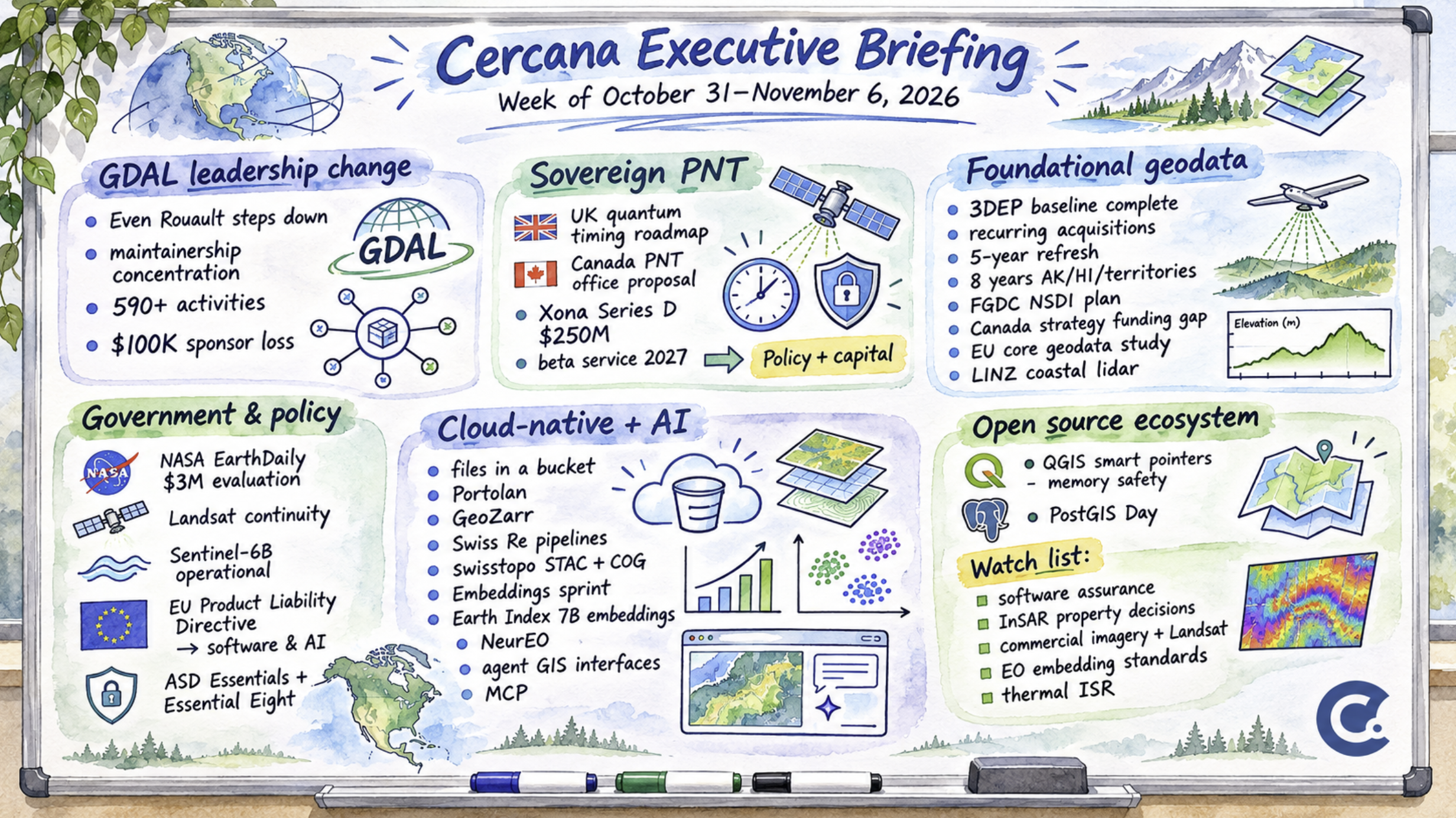
168 feeds monitored. Published November 6, 2026.
Executive Summary
Even Rouault’s departure from the GDAL Project Steering Committee was the week’s most consequential development. GDAL underpins much of the geospatial software ecosystem, and Rouault has been central to its development for years. He gave no reason for stepping down, named no successor, and left his future development involvement unclear. His departure raises questions about the industry’s dependence on a relatively small number of maintainers.
Elsewhere, the UK and Canada advanced policies treating assured positioning, navigation and timing (PNT) as sovereign infrastructure. Private investment is also backing commercial alternatives to GPS, including Xona Space Systems’ recent US$250 million funding round. Public geospatial data programs face a different challenge. In the United States, Canada, Europe and New Zealand, attention is turning toward the recurring costs of maintaining and governing foundational datasets.
Funding runs through much of this week’s coverage. Governments are establishing strategies and governance structures, but implementation resources remain uncertain. GDAL’s leadership succession, procurement for PNT resilience, and the Federal Geographic Data Committee’s (FGDC) forthcoming National Spatial Data Infrastructure (NSDI) implementation plan should provide a clearer picture of how these commitments will be sustained.
Major Market Developments
GDAL leadership departure raises questions about maintainership
On November 4, Even Rouault informed the gdal-dev mailing list that he was stepping down as a member and chair of the GDAL Project Steering Committee (PSC). He said he would follow the project only “from a distance” and offered to help if needed. He provided no reason for his decision or details about succession. geoObserver described Rouault as GDAL’s lead maintainer and chief developer.
It’s unclear how much development work Rouault intends to continue. GDAL has other contributors, established governance and an open codebase, so an orderly transition remains possible. Still, maintainership of core geospatial libraries is concentrated among relatively few specialists. A September sponsorship appeal attributed more than 590 development and maintenance activities to Rouault over the preceding year. The same appeal reported the loss of $100,000 in annual support from two former gold sponsors.
For vendors and agencies that rely on GDAL, the concern is how much their own development and maintenance work depends on individual upstream contributors. The selection of new PSC leadership, subsequent releases and commits, and changes in corporate sponsorship should help clarify how the project adjusts.
Assured positioning and timing gains attention as sovereign infrastructure
The UK and Canada have separately advanced policies addressing PNT resilience. On October 27, the UK Space Agency published its Quantum Technology Roadmap for Space, recommending that quantum timing be treated as a sovereign capability to reduce dependence on GNSS-derived timing.
Canada’s PNT Resilience Framework, published October 22, proposes establishing a national PNT office within Innovation, Science and Economic Development Canada. Its Plan for a Stronger Canada, released October 29, identifies space-based navigation among the technologies supporting national security and sovereignty.
Commercial alternatives are also attracting capital. Xona Space Systems closed a US$250 million Series D round at a US$2.45 billion valuation, while the Canadian government committed C$15 million to support Xona’s operations centre in Montréal.
Neither government’s policy documents necessarily commit funding for implementation. Xona’s financing also reflects investor expectations that may extend beyond assured PNT demand. Whether these developments produce new procurement requirements will become clearer as governments allocate budgets and launch programs.
Surveying, autonomous systems and network timing are among the applications that could face additional resilience requirements. Government contract awards and Xona’s planned 2027 beta service will provide further evidence of how the market is developing.
Public geospatial data programs confront the economics of maintenance
Several national geospatial programs are turning toward recurring maintenance, with funding and governance arrangements still evolving.
USGS has completed the first nationwide 3D Elevation Program (3DEP) elevation baseline and is transitioning toward recurring acquisitions. Areas with data five or more years old receive priority for refresh, with an eight-year threshold for Alaska, Hawaii and the territories. Through its partnership program, USGS can contribute toward Quality Level 1 or 2 repeat acquisitions. Cost-sharing requirements and additional quality upgrades affect how much partners must contribute.
A review of the FGDC’s NSDI Strategic Plan 2025–2035 by Joseph Kerski found that the promised implementation plan and performance metrics were not readily available.
Canada’s national geospatial strategy lacks a dedicated implementation budget. Finance received a score of just 17.8 out of 100 in the country’s spatial data infrastructure assessment. The European Commission has begun an 18-month study of core geospatial data, while Land Information New Zealand (LINZ) has started a six-month lidar campaign contributing to its goal of mapping 40% of the country’s coastline in 3D.
The programs differ in scope and maturity, but each faces the continuing cost of maintaining public geospatial information. For survey and lidar providers, recurring acquisitions and partnership funding could support sustained work. Data consumers will need to pay closer attention to acquisition dates, quality levels and reference systems, particularly as the United States progresses toward replacing NAD 83 with NATRF2022.
The FGDC implementation plan and future 3DEP funding announcements should clarify how some of these responsibilities will be funded and managed.
Notable Company Activity
Product Releases
- Hydrosat: Announced Nyktòs, a high-resolution mid-wave infrared satellite program aimed at tactical intelligence, surveillance and reconnaissance (ISR) for NATO and allied governments. New European facilities are planned. Satellite specifications, launch dates and resolution figures haven’t been disclosed.
- IQGeo: Introduced Visual Agent Studio for validating telecom field photographs and extracting asset information. IQGeo describes the product as production-ready but hasn’t identified customers. Its reported performance statistics come from the company’s own survey.
- Esri: Added a natural-language AI assistant to ArcGIS for Teams. The capability is in beta, requires administrator enablement and is currently limited to ArcGIS for Teams.
- Trimble ecosystem: Trimble integrated drone data processing into WorksManager. Separately, Sodex Innovations introduced SDX-AutoScan, which generates daily as-built records using equipment running Trimble Earthworks.
- MapTiler: Released Server 4.9 with a reduced software bill of materials (SBOM), intended to simplify compliance reviews.
- Avant (New Zealand): Launched LandSure, offering property-level ground-movement reports to homeowners and prospective buyers using Sentinel-1 InSAR data processed by SatSense.
Partnerships
- EarthDaily and Geosolutions: Entered a reseller agreement covering six Central American countries from October 2026 through December 2029. Initial markets include government, environmental monitoring, agriculture and insurance. Financial terms weren’t disclosed.
- GHD and Autodesk: Signed a memorandum of understanding to collaborate on AI-enabled engineering design.
- UK Hydrographic Office and ESA BASS: Invited companies to develop commercial services combining S-100 hydrographic data with satellite information.
Funding and M&A
- Xona Space Systems: Announced a US$250 million Series D round on October 22 at a US$2.45 billion valuation, led by Future Ventures.
Government and Policy Developments
NASA awarded EarthDaily a US$3 million contract to evaluate how imagery from the EarthDaily Constellation could support Landsat-aligned requirements. The award falls under the NASA–USGS Sustainable Land Imaging Commercial Transition Initiative.
The contract concerns evaluation rather than routine imagery procurement. Commercial optical data is now part of a formal assessment of how to sustain the Landsat record. Additional awards, particularly those involving other commercial constellations, would help establish how NASA intends to incorporate commercial imagery into future operations.
Copernicus Sentinel-6B entered operational service in late October, extending the continuous satellite sea-level record that began in 1992.
The revised EU Product Liability Directive will apply to newly marketed products beginning December 9, 2026, extending liability for defective products to software and AI systems. Noncommercial free and open-source software is exempt. Geospatial AI vendors and other software suppliers operating in Europe will need to account for the revised requirements.
GeoAI and the Law also examined how existing data laws affect geospatial AI development and deployment. These include state restrictions on selling precise location data and the US Department of Justice’s bulk data rule. Governments and large enterprises may also pass related compliance requirements to their suppliers through contracts.
Australia’s Signals Directorate launched ASD Essentials, a broader cybersecurity framework covering enterprise IT, operational technology and cloud environments. Essential Eight will remain in place during the transition, and organizations must continue meeting existing regulatory requirements.
Technology and Research Trends
Cloud-native geospatial systems are seeing more operational deployments, while research into Earth observation embeddings and conversational GIS interfaces continues.
At CNG Zürich, which drew approximately 80 attendees, presenters discussed Portolan, an open specification and toolkit for managing spatial data infrastructure through files and metadata. GeoZarr pyramid tooling was also demonstrated, reportedly producing a global 10-metre raster in approximately three hours.
Swiss Re described replacing a desktop-based update process with automated cloud-native pipelines for catastrophe-model geocoding. Swisstopo publishes imagery as Cloud Optimized GeoTIFFs (COGs) to a national STAC catalogue within hours of acquisition. Both examples show cloud-native formats being used for recurring data operations.
Data sovereignty also came up in the discussion. Participants argued that object storage can support jurisdictional control when organizations retain authority over where data is hosted. Hosting location is only part of that question, however, since governance and access-control obligations remain.
Research into Earth observation embeddings received renewed attention at the second Geo-Embeddings Sprint, held October 27–28. Participants identified standards, evaluation and adoption as priorities.
At CNG Zürich, a presenter reported that Earth Index can search approximately seven billion embeddings in tens of milliseconds on a single node. Independent benchmarking hasn’t yet established that performance.
Separately, the NeurEO preprint applies neuroscience methods to interpret geospatial embedding features. It reports an effective dimensionality of fewer than ten dimensions for the UK, raising the possibility that some regional applications may require less model complexity than currently assumed. That conclusion will require further validation.
Conversational and agent-based GIS interfaces are progressing, although their maturity varies. EBP demonstrated a proof of concept connecting a language model to Swiss municipal energy and cadastral services through MCP servers, with responses grounded in source data. Caching and parallel queries reportedly improved latency, but the project hasn’t published an accuracy evaluation.
Esri’s ArcGIS for Teams assistant remains in beta. IQGeo has introduced Visual Agent Studio as a commercial product, although independent performance results aren’t yet available.
For now, the clearest operational evidence comes from the cloud-native data pipelines. The embedding research and agent-interface demonstrations are promising, but published evaluations and sustained deployments are still relatively limited.
Open Source Ecosystem
Oslandia published an update on its work to improve memory safety in QGIS. The project is migrating portions of approximately 1.5 million lines of C++ to smart pointers, using a deterministic code-transformation tool followed by human review.
The team chose not to use AI, consistent with the QGIS project’s moratorium on AI-generated core code. A QGIS.org grant covers part of the work, and Oslandia is seeking additional financial support.
This is the kind of specialized maintenance that can be difficult to fund, even for widely deployed software. Alongside the GDAL leadership change, the QGIS work illustrates how much the broader geospatial ecosystem depends on sustained contributions from relatively small development teams.
Elsewhere in the community, PostGIS Day is scheduled for November 19. Community voting on 282 FOSSGIS 2027 submissions runs through November 10, and FOSS4G North America convened in Sacramento on November 2–4.
Watch List
- Software assurance in geospatial systems: MapTiler’s SBOM changes, QGIS memory-safety work, Australia’s cybersecurity transition and the EU Product Liability Directive may affect procurement requirements. Evidence of buyer demand would include mandates for SBOMs, memory-safety documentation or related certifications. Reassess by the first quarter of 2027 if procurement practices remain unchanged.
- InSAR for consumer property decisions: Avant’s LandSure brings ground-movement reports directly into property transactions. Integration by insurers, lenders or conveyancing platforms, or the appearance of comparable services in other markets, would indicate broader commercial interest.
- Commercial imagery in Landsat continuity: NASA’s EarthDaily contract is an evaluation. Production purchases or additional contracts involving other vendors would clarify whether commercial data will become part of operational continuity planning.
- EO embedding standards: The second Geo-Embeddings Sprint renewed work on interoperability, evaluation and adoption. Draft specifications and customer deployments would demonstrate progress. Reassess if no concrete output emerges within the next quarter.
- Commercial thermal imagery for sovereign ISR: Hydrosat’s Nyktòs targets European defense and security demand. Launch commitments, funding disclosures and named government customers remain the next commercial milestones.
Top Posts of the Week
- Hiobsbotschaft: Even Rouault verlässt GDAL – geoObserver – November 5, 2026 – Reports Rouault’s departure from the GDAL Project Steering Committee, links to his original message and examines the implications for the project’s continuity.
- The Billion-Dollar Basemap – xyHt – November 5, 2026 – Examines 3DEP’s transition from nationwide baseline acquisition to recurring maintenance, including acquisition cycles, cost-sharing arrangements and reference-system modernization.
- Canada’s New National Security Strategy Raises the Stakes for Geospatial Infrastructure – GoGeomatics – November 1, 2026 – Examines Canada’s sovereign geospatial ambitions alongside the funding and governance limitations of its national geospatial strategy.
- Files in a bucket: CNG Zürich – Spatialists – November 1, 2026 – Covers Portolan, GeoZarr, operational cloud-native deployments and work on geospatial embeddings.
- GeoAI and the Law Newsletter – GeoAI and the Law – November 3, 2026 – Summarizes a WGIC Horizons discussion of approximately 90 legislative and policy developments affecting geospatial AI, including data governance, liability and procurement requirements.
The Cercana Executive Briefing draws on 168 geospatial feeds aggregated by geofeeds.me.
Subscribe to receive the Cercana Executive Briefing by email.