
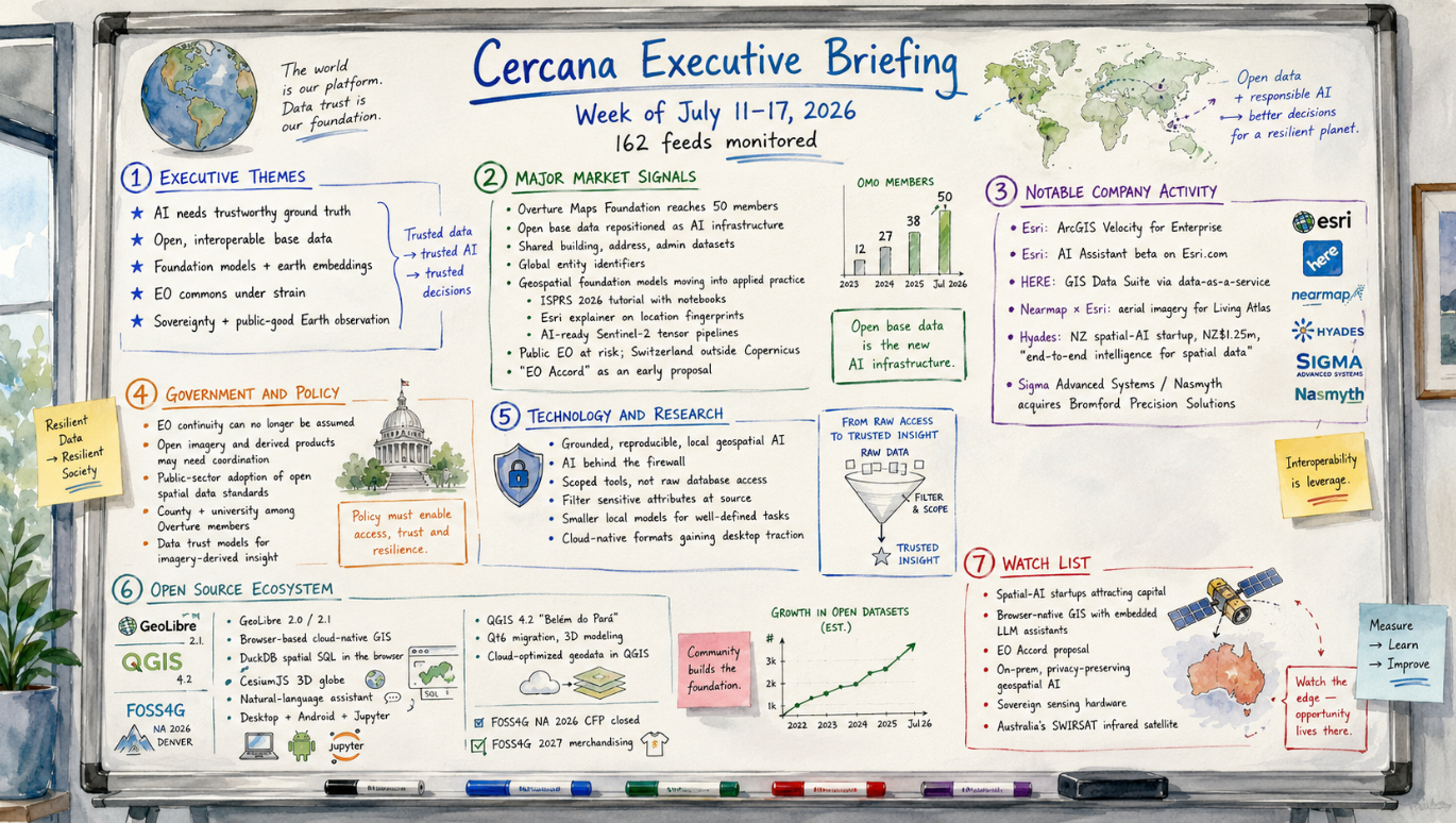
162 feeds monitored. Published July 17, 2026.
Executive Summary
Trustworthy geospatial data moved closer to the center of the AI market this week. Overture Maps Foundation crossed 50 members and used the milestone to make a direct case for open, interoperable base data as grounding for AI systems. Geospatial foundation models also became more accessible. An ISPRS 2026 tutorial paired earth-embedding concepts with open notebooks, while Esri explained how foundation models learn the “fingerprint” of a place for a mainstream GIS audience. Taken together, the pieces of a geospatial AI stack are becoming easier to see: authoritative data, learned representations of place, and tooling that practitioners can begin testing.
A separate debate raised questions about who will continue supplying that data. Commentary prompted by Switzerland’s decision to remain outside Copernicus argued that tighter budgets and weaker political commitment could erode Earth observation as a shared public asset. That concern arrives as commercial data services expand and AI systems demand fresher, more authoritative geographic data. Greater dependence on commercial providers, national programs, and data intermediaries may follow.
Major Market Signals
Open base data is becoming AI infrastructure
Overture Maps Foundation presented its expansion to 50 members as more than an organizational milestone. Its case is straightforward: AI outputs depend on the spatial data used to ground them, and that data works better when it is open, interoperable, and consistently identified. Its membership now spans technology companies, government, academia, and nonprofit organizations. The list includes ride-hailing and fleet-telematics firms, a US county, and a public university.
Base-map data has long been treated as a commodity layer. Overture is trying to recast it as governed infrastructure. Commercial data-as-a-service providers are making a related bet. A reliable supply of current, machine-consumable geographic data could become a durable position beneath AI-enabled applications and workflows. That position may prove more defensible than many of the application layers being built above it.
Geospatial foundation models move toward applied use
Geospatial foundation models became easier to approach from several directions this week. An ISPRS 2026 tutorial paired openly licensed teaching materials with hands-on notebooks for prediction, geo-semantic search, and related use cases. Esri introduced location fingerprints to a broader GIS audience. Practitioner articles showed how to build AI-ready tensor pipelines from Sentinel-2 data.
This does not mean the technology is ready for routine deployment everywhere. It does mean more teams can test it without first assembling a research program. Embeddings and foundation models are likely to show up more often in roadmaps, pilots, and procurement discussions while buyers work out where they outperform established methods.
Public Earth observation faces structural pressure
A widely circulated analysis argued that public Earth observation is becoming less secure as budgets tighten, political consensus weakens, and commercial alternatives expand. Switzerland’s decision to remain outside Copernicus served as one example of a broader coordination problem. The proposed response, an “EO Accord” modeled on earlier international efforts, remains preliminary. Even so, the proposal gives the concern a concrete institutional form rather than leaving it as another argument about shrinking budgets.
The commercial consequences are easier to identify. Any decline in the continuity of public imagery would increase the value of commercial constellations, sovereign programs, and data intermediaries. It would also change the economics of products and research programs built around open EO data.
Notable Company Activity
Product Releases
- Esri: Made ArcGIS Velocity available for ArcGIS Enterprise, extending real-time ingestion, analytics, and automated alerting to self-hosted deployments. The release serves organizations that need real-time capability while keeping data within their own environments.
- Esri: Launched an AI Assistant in beta on Esri.com, extending conversational AI into the company’s public web properties.
- HERE Technologies: Released its GIS Data Suite through a data-as-a-service model, allowing Esri users to connect to continuously updated foundational data from within ArcGIS environments.
Partnerships
- Nearmap and Esri: Signed an exclusive agreement making Nearmap the aerial-imagery basemap provider for ArcGIS Living Atlas of the World. The arrangement expands Nearmap’s distribution through the Esri platform and gives Living Atlas users broader access to high-resolution imagery of the built environment.
Funding and M&A
- Hyades: The Auckland-based spatial AI startup raised NZ$1.25 million to develop a platform that combines satellite imagery, drone data, radar, and other spatial sources into AI-ready models. Its initial targets include insurance, agriculture, mining, and climate applications, where analysts still spend substantial time assembling incompatible data before they can model risks such as flooding, wildfire, or cyclone exposure. The company remains in an early alpha stage, making this a bet on the data-engineering layer beneath spatial AI rather than on a mature product with established market traction.
- Sigma Advanced Systems (Nasmyth): Acquired UK aerospace manufacturer Bromford Precision Solutions, adding capacity in the aerospace and defence supply chain behind sensor and platform manufacturing.
Government and Policy Developments
The main policy question this week concerned the continuity of public Earth observation. Treating EO as a durable public good depends on more than annual funding. It also requires long-term coordination among governments and institutions. Public-sector organizations that rely on open imagery and derived products may need to identify where their operations, research, and procurement quietly assume uninterrupted access.
Public participation in Overture raises a different governance issue. A US county and a public university are now among its members, suggesting that some public institutions see open, interoperable base data as shared infrastructure. That approach could affect procurement, data exchange, and entity identification across agencies. Separate coverage of data-trust models for imagery-derived intelligence also focused less on acquiring data and more on governing it once it enters operations.
Technology and Research Trends
Geospatial AI is moving closer to governed data stores. Open teaching resources and implementation guidance are making foundation models and earth embeddings easier to test. At the same time, data-integration practitioners are describing architectures that expose narrowly scoped tools to models while keeping raw data and sensitive attributes behind the firewall.
That architecture favors smaller local systems matched to defined tasks, especially in regulated and security-conscious environments. Cloud-native formats are also becoming more common in desktop tools, making it easier to work with the same data across local and hosted environments. The common thread is proximity: bring the model to the governed data rather than move sensitive data to an external model service.
Open Source Ecosystem Signals
GeoLibre released versions 2.0 and 2.1 with browser-based vector and raster tools, a CesiumJS 3D globe, DuckDB-backed spatial SQL, and a natural-language assistant. It also runs as a desktop application, on Android, and within Jupyter. The release combines several ideas that have often appeared separately: local analytical execution, 3D visualization, and conversational interaction in a lightweight GIS. Its interest lies less in any single feature than in the way those features are being assembled into a smaller, more portable product.
The QGIS ecosystem remained active after the early-July release of QGIS 4.2 “Belém do Pará.” Coverage examined its 3D capabilities, connected the release to the FOSS4G host city, and showed cloud-optimized formats in desktop workflows. FOSS4G North America 2026 closed its call for papers, while early FOSS4G 2027 activity appeared in the community. Release activity and the conference pipeline both remain healthy.
Watch List
- Spatial AI startups: Hyades is an early example of seed investment moving toward tools that prepare fragmented imagery, sensor, and mapping data for AI-driven risk models.
- Browser-native GIS: GeoLibre combines in-browser spatial SQL, 3D visualization, and natural-language interaction in a form that could recur across lightweight GIS products.
- The EO Accord proposal: The concept is preliminary, but it gives the debate over public Earth observation a specific coordination model.
- On-premises AI for sensitive geospatial data: Local models and narrowly scoped tools may gain traction in regulated and security-conscious sectors.
- Sovereign sensing hardware: Australia’s SWIRSAT infrared satellite reflects continued national investment in independent Earth observation capability.
Top Posts of the Week
- Overture Maps Foundation Reaches 50 Members as Industry Converges on Open Data to Ground AI – Overture Maps Foundation – Positions open, interoperable base data as grounding for AI systems and states the week’s central market argument most directly.
- Public EO at risk – Spatialists – July 13, 2026 – Examines pressure on Earth observation as a public good and proposes an international coordination mechanism in response.
- Foundation models and earth embeddings – Spatialists – July 15, 2026 – Presents openly licensed ISPRS 2026 teaching material that makes geospatial foundation models easier to test in practice.
- Every place has a fingerprint: How foundation models are learning locations – ArcGIS Blog – Introduces foundation-model concepts to a mainstream GIS audience and shows the technique moving into vendor education.
- GeoLibre 2.0.0 released – Spatialists – July 14, 2026 – Combines browser-based spatial SQL, 3D visualization, and natural-language interaction in a lightweight GIS.
Cercana Executive Briefing is generated from 162 feeds aggregated by geofeeds.me.