
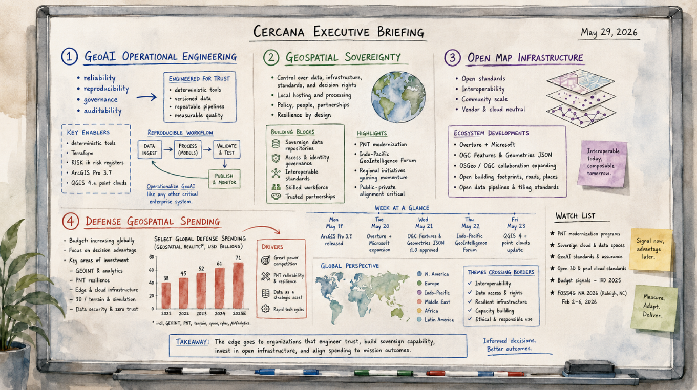
161 feeds monitored. Published May 29, 2026.
Executive Summary
This week’s geospatial market activity centered on two related themes: the operational maturation of GeoAI and the growing importance of geospatial sovereignty. Both carry implications for procurement, vendor strategy, governance, and workforce planning.
On the AI side, reporting from the 2nd annual ESA-NASA Workshop on AI Foundation Models for Earth Observation reinforced a shift already visible across the market. The question is no longer whether GeoAI can perform useful work. The question is whether it can be trusted in operational settings. That requires engineering discipline, governance infrastructure, auditable workflows, and standardized tooling. Sparkgeo’s post-workshop analysis and Bill Dollins’ bimonthly GeoAI state-of-play survey arrived at similar conclusions from different angles: reliability, reproducibility, and governance are becoming core requirements for organizations selling or deploying spatial AI. Esri’s ArcGIS Pro 3.7 assistant beta and GeoAI Image Analyst updates also point to platform-level AI integration moving closer to routine production use.
On the sovereignty side, Geospatial World Forum 2026 produced senior-level statements that treated spatial data control as a strategic concern across Africa, the Gulf, and Europe. The announcement of the Indo-Pacific GeoIntelligence Forum, combined with a $103 million U.S. Department of Defense PNT contract award, points to continued defense investment in geospatial capability.
These two themes are connected. Sovereign AI and operational GeoAI depend on many of the same questions: who controls the data, who controls the model, what trained it, who can audit the output, and what rules govern reuse. Organizations that can answer those questions clearly will be better positioned in procurement environments where trust, provenance, and control are becoming part of the buying criteria.
Major Market Developments
GeoAI Has Entered Its Operational Engineering Phase
The 2nd ESA-NASA Workshop on AI Foundation Models for Earth Observation reflected a more mature industry conversation. Reporting from Sparkgeo’s James Banting described a shift from capability exploration toward operational readiness. In 2025, much of the discussion centered on whether foundation models could perform useful geospatial work. In 2026, the emphasis has moved toward reliability, latency, governance, and production deployment.
Several operating principles are gaining traction. LLMs are being positioned as orchestrators of deterministic tools rather than as generators of final analytical answers. Outputs need to be grounded in SQL, APIs, and auditable pipelines. Prompts should remain simple while technical complexity is embedded in tools and workflows. Generated analysis code should be retained for reproducibility.
Bill Dollins’ GeoAI survey for April and May 2026 documented a similar transition, with additional attention to regulation and procurement. RICS professional standards now require documented AI risk registers for surveyors. NATO has called for common governance standards at GEOINT. Proposed U.S. federal procurement clauses are moving toward requirements for American-developed AI components, government ownership of model outputs, and restrictions on using contract work to improve commercial models.
For vendors, this changes the sales conversation. Demonstrations still matter, but compliance documentation, auditability, reproducibility, and operating controls are becoming part of the evaluation process.
Geospatial Sovereignty Is Becoming a Multi-Region Strategic Concern
Geospatial World Forum 2026 produced a concentrated set of discussions on sovereignty. Sessions covered space access as a national right, sovereign GIS and digital twins, spatial justice and Africa’s geospatial future, and data sovereignty as an executive theme. The Indo-Pacific GeoIntelligence Forum 2026 was also announced as a dedicated forum for network-centric warfare and defense geospatial capabilities.
Taken alongside U.S. federal AI procurement clauses, Colorado’s AI Act, Virginia’s geolocation restrictions, and Canada’s sovereign AI discussion, sovereignty has moved beyond a narrow European regulatory context. It is appearing across regions as a strategic posture tied to national infrastructure, defense, land administration, precision navigation, and data control.
The practical implication is straightforward. Geospatial products and services that touch sensitive public functions will increasingly need to address provenance, jurisdiction, model governance, data rights, and operational control before procurement decisions are made.
Open Map Infrastructure Is Moving Into Enterprise Production
Overture Maps Foundation published a case study describing Microsoft’s adoption of Overture data for its internal building footprint and address layers. Microsoft replaced custom internal datasets, retired parts of its pipeline infrastructure, and reduced development cycles from months to weeks. The case study cites address accuracy improvements in South America, Mexico, and Japan, a full data layer transition completed in July 2024, and a hackathon team integrating Overture into Azure Maps SDKs in under a week.
Sparkgeo separately described its work on a self-healing Overture Places dataset. The system now monitors 9.4 million of the 15.5 million U.S. places in the dataset using real-time observations. Monthly observations grew from fewer than one million in May 2025 to more than 50 million by March 2026.
Spatialists also reported on the OGC Features and Geometries JSON standard as an evolution beyond GeoJSON. Taken together, these developments show open, collaborative map infrastructure moving from experimentation into enterprise use. Microsoft’s decision to reduce custom code and technical debt through shared infrastructure will be watched by other platform operators facing similar maintenance and data quality pressures.
Defense Geospatial Spending Is Advancing Across Regions
Apogee received a five-year, $103 million task order from the U.S. Department of Defense to support positioning, navigation, and timing modernization and sustainment planning across the international PNT enterprise.
Spain’s Ministry of Defence launched the FENIX project with UAV Navigation-Grupo Oesía and Alpha Unmanned Systems to develop heterogeneous unmanned vehicle swarms with advanced navigation and control. Australia held a military geospatial team evaluation exercise, reported by Spatial Source. GMV announced advances in secure timing and synchronization through Galileo PRS technology, aimed at defense and critical infrastructure markets.
These developments span North America, Europe, and the Indo-Pacific. They point to continued investment in resilient positioning, sovereign navigation, unmanned systems, and geospatial intelligence infrastructure.
Notable Company Activity
Product Releases
Esri launched the ArcGIS Pro 3.7 assistant beta, an AI-powered interface for automating common GIS workflows within Pro. The same release cycle included updates to GeoAI Image Analyst, ArcGIS Earth, ArcGIS StoryMaps, and cloud-enabled workflows in ArcGIS Reality Studio. The release pattern suggests continued movement toward AI-assisted platform workflows ahead of the summer user conference cycle.
Focal Point Positioning launched Precise+, a service targeting sub-meter GNSS accuracy in difficult environments such as urban canyons, dense foliage, and covered parking. The positioning market continues to segment around operating conditions, with more products designed for degraded environments.
OpenCage extended its Geosearch product to include postcode search, broadening its use in address autocomplete and geocoding integrations.
Partnerships
EarthDaily Analytics and Geospatial Intelligence announced a partnership to strengthen Earth observation capabilities in the Australian market. The partnership expands EarthDaily’s regional presence as Australian government and defense procurement continue to emphasize sovereign and allied EO capability.
Microsoft and Overture Maps Foundation represent the most detailed enterprise integration disclosed by Overture to date. Microsoft’s use of Overture data and infrastructure provides an enterprise reference case for the open collaborative model.
Funding and M&A
Octave Intelligence listed on Nasdaq New York. The company focuses on geospatial intelligence and Earth observation analytics. Its market reception will provide a reference point for other EO analytics firms considering public market activity.
Government and Policy Developments
EUSPA released a new EU Space Market Report projecting continued growth in GNSS-enabled services, with coverage of downstream market dynamics in Earth observation, satellite communications, and precision navigation. The report provides a useful benchmark for vendors positioning around European market demand.
The Indo-Pacific GeoIntelligence Forum 2026 creates a formal venue for defense geospatial standards, network-centric warfare, and capability alignment among Indo-Pacific partners. It suggests the region is developing its own geospatial intelligence architecture rather than relying only on European or North American models.
NASA’s AVIRIS-3 airborne hyperspectral campaign is opening an Expression of Interest for Australian researchers and institutions. AVIRIS-3 provides 426-band hyperspectral coverage for research applications in precision agriculture, ecosystem monitoring, and environmental compliance. Campaign participation may help indicate which organizations and workflows are moving closer to commercial use of hyperspectral data.
Bill Dollins’ GeoAI governance survey documented several overlapping regulatory developments: Colorado’s AI Act shifting toward transparency requirements for spatial decision systems, the EU’s Digital Omnibus extending AI Act compliance timelines to December 2027 while retaining high-risk treatment for land use, critical infrastructure, and emergency management GeoAI, and proposed U.S. federal procurement clauses governing AI outputs, commercial model improvement, and American-developed components. Organizations pursuing U.S. federal work should continue monitoring GSA clause development.
Technology and Research Trends
The ESA-NASA workshop showed geospatial foundation model tooling beginning to standardize around the TorchGeo ecosystem. TerraTorch and TerraKit joined TorchGeo, presenting a more unified framework for model training, evaluation, and data preparation. Standardization matters for production use because it reduces implementation variance, improves reproducibility, and supports maintainable deployment architectures.
The workshop also elevated embeddings as an infrastructure concern rather than only a performance optimization. Google’s AlphaEarth Foundation embeddings were discussed as a possible proxy for ground truth in selected research applications. One reported experiment recovered 97 percent of downstream task utility from AEF embeddings alone. This does not replace ground-truth collection, but it could affect how organizations plan and prioritize future field validation campaigns.
The Spatial Edge explored natural-language search over satellite imagery archives. This capability addresses a persistent Earth observation adoption barrier: analysts often know what they want to find but not how to express the query in catalog terms. Broader availability of natural-language archive search could make EO workflows more accessible to non-specialist users.
MappingGIS documented QGIS 4.x point cloud processing improvements, including rendering, classification, and analysis capabilities for LiDAR and photogrammetric point clouds. As point clouds become common deliverables for infrastructure inspection, urban planning, and forestry, open-source tooling quality will affect the competitiveness of workflows built around QGIS and related components.
Open Source Ecosystem Developments
FOSS4G North America 2026 is approaching, with a program covering cloud-native geospatial, AI integration, open standards, and field data collection. The conference remains a useful indicator of where open-source geospatial practitioners are putting their attention.
Bill Dollins’ GeoAI state-of-play survey raised a concern about AI coding tools and open-source maintenance. AI-assisted development may increase surface-level contributions while also adding review burden for maintainers. That can pull attention away from foundational work in projects such as GDAL, xarray, QGIS, PostGIS, and STAC. The QGIS Sustainability Initiative donated 168 hours of expert maintenance time in 2025 to address technical debt. Organizations whose production systems depend on the shared geospatial stack have a stake in whether that maintenance work is funded.
OGC is advancing the Features and Geometries JSON specification as a standardized evolution beyond GeoJSON. The specification addresses geometry type gaps and improves interoperability. Adoption is still early, but coverage from Spatialists indicates rising visibility among developers.
Watch List
Octave Intelligence Nasdaq listing: Public market reception will help establish a reference point for other EO analytics companies considering capital markets activity in 2026 and 2027.
Leaf Space TreeNet: Leaf Space introduced TreeNet as a space connectivity architecture for the “Internet of Space.” Satellite-to-satellite and multi-orbit connectivity infrastructure may become an important complement to ground station networks as small satellite operators evaluate uplink dependencies.
MainPro remote sensing products: MainPro announced online availability of a commercial remote sensing analysis product platform. New entrants continue to target vertical use cases such as precision agriculture and environmental monitoring, even as the EO analytics market faces consolidation pressure.
FME vs. AI: A Spatialists post raised a practical question for data integration teams: when does AI-powered spatial ETL begin to displace purpose-built integration platforms such as FME? The question remains early, but it is appearing in practitioner discussions and may become part of renewal and expansion decisions.
Erin Brockovich data center mapping campaign: The environmental activist launched a crowdsourced geographic mapping effort to document data center locations and environmental impacts. The combination of citizen geospatial collection, infrastructure scrutiny, and high-profile advocacy is relevant for vendors working in environmental monitoring, infrastructure planning, and public-facing geospatial applications.
Top Posts of the Week
- Reliability Is GeoAI’s New Metric, Sparkgeo
Firsthand reporting from the ESA-NASA AI Foundation Models workshop, with a focus on what operational GeoAI requires beyond model performance. - Geospatial AI State of Play, April–May 2026, geoMusings
A synthesis of GeoAI governance, procurement, regulatory, and technical trends across NATO, RICS, Colorado, the EU, and the open-source ecosystem. - Powering Microsoft Maps with Overture: Faster Releases, Better Data, Overture Maps Foundation
A detailed enterprise case study showing Microsoft’s use of Overture data and shared infrastructure to improve data quality and reduce custom pipeline burden. - Space for All: Why Geospatial Sovereignty is Every Nation’s Right, Geospatial World
UNOOSA’s discussion of space access and geospatial sovereignty at Geospatial World Forum 2026. - Twenty Years, Part Three, geoMusings
A reflection on geospatial capability, decision-making, and the risk that AI accelerates familiar technology cycles without addressing the harder institutional questions.
Cercana Executive Briefing is generated from 161 feeds aggregated by geofeeds.me.