161 feeds monitored. Published May 22, 2026.
Executive Summary
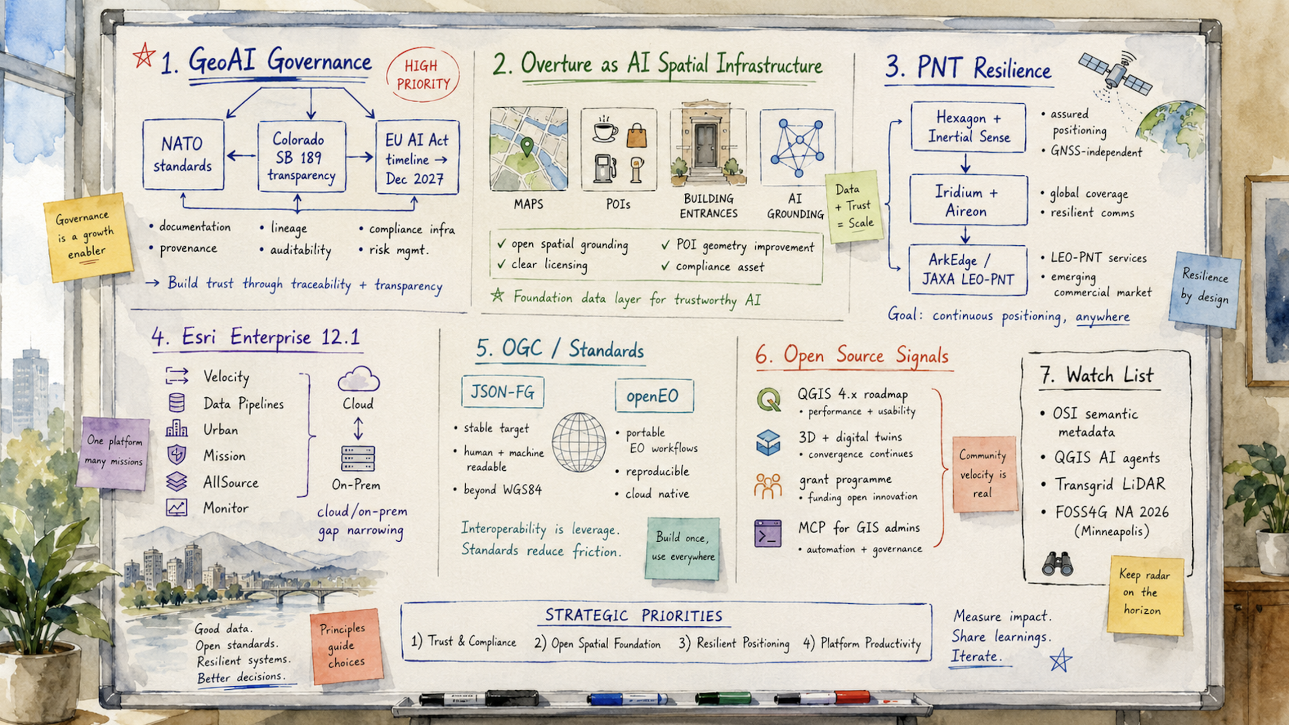
The most consequential geospatial market development this week was not a product launch. It was the convergence of regulatory, standards, and governance activity around GeoAI. NATO’s call for standards on AI-enhanced geospatial intelligence, surfaced at GEOINT 2026, Colorado’s algorithmic transparency pivot under SB 189, and the EU Digital Omnibus agreement extending AI Act compliance deadlines to December 2027 arrived in the same window. Taken together, they point to a maturing regulatory perimeter for commercial vendors selling spatial AI into defense markets, enterprise risk systems, or EU-regulated organizations.
The practical question is no longer whether GeoAI governance is coming. It is which standards and documentation practices will emerge first, and how quickly vendors can build the infrastructure needed to support them.
That policy activity landed alongside an Overture Maps repositioning that deserves separate executive attention. Two substantive posts, one on open spatial grounding for AI models and another on image-anchored POI geometry improvement through the Places Imagery Task Force, describe Overture less as a mapping dataset and more as spatial infrastructure for AI systems. This intersects with the regulatory story. As GeoAI vendors face documentation, provenance, and lineage requirements, a well-governed open dataset with clear licensing and improving geometric accuracy becomes a compliance asset, not just a convenience.
The week’s PNT resilience activity also deserves attention. Hexagon completed its acquisition of Inertial Sense, Iridium announced plans to acquire Aireon, and ArkEdge Space completed a JAXA-commissioned study on GNSS-independent LEO positioning. Assured positioning is forming into a distinct commercial market segment. The regulatory timeline for GeoAI and the investment trajectory around PNT are the two strategic threads to keep watching.
Major Market Signals
GeoAI Regulatory Pressure Becomes Concrete
Three independent governance vectors converged this week to create the clearest regulatory environment yet for commercial GeoAI vendors. NATO’s call at GEOINT 2026 for common standards on AI-enhanced geospatial intelligence could reshape expectations for model documentation, training data provenance, and confidence thresholds for vendors selling into allied defense markets. Colorado’s SB 189 pivoted from algorithmic risk management mandates to transparency disclosure requirements, narrowing immediate compliance burdens while preserving the need for documentation in spatial decision systems. The EU Digital Omnibus political agreement extended the AI Act compliance runway to December 2027, giving organizations more time while removing any remaining ambiguity that preparation is mandatory.
For executives, the practical implication is straightforward. Geospatial AI now sits inside the regulatory scope of multiple major jurisdictions at once. Vendors that treat compliance as a future planning exercise rather than an active program may find themselves disadvantaged as buyers begin asking for evidence, lineage, and governance artifacts during procurement.
Esri Delivers a Broad Enterprise Release
ArcGIS Enterprise 12.1 arrived this week with an unusually broad launch cadence. ArcGIS Velocity for Enterprise, ArcGIS Data Pipelines for Enterprise, ArcGIS Urban, ArcGIS Mission, ArcGIS AllSource 1.6, Scene Viewer, Web Editor, Business Analyst Enterprise, Maritime, Excalibur Q2, and Monitor 2026.0 all received release coverage.
The coordinated rollout indicates that Esri is closing the capability gap between its cloud and on-premises platforms. That matters for organizations with air-gapped, sovereign-cloud, or regulatory requirements that have kept them on-premises while cloud-native tooling advanced. For competitors and open-source alternatives, the argument that cloud Esri tools remain materially ahead of Enterprise becomes harder to sustain in customer evaluations.
PNT Resilience Emerges as a Commercial Market
Positioning, navigation, and timing moved this week from a defense-centered concern toward a more recognizable commercial market segment. Hexagon completed its acquisition of Inertial Sense, adding tactical-grade GNSS and inertial navigation technology to its assured PNT portfolio. Septentrio, a Hexagon subsidiary, unveiled the mosaic-G5 P8, a 2.2-gram, 23mm by 16mm multi-frequency module with AIM+ Ultimate anti-jamming and anti-spoofing technology for UAVs, marine vessels, and rail. ArkEdge Space completed a JAXA-commissioned feasibility study on a dedicated, GNSS-independent LEO-PNT satellite system. Iridium announced plans to acquire Aireon to consolidate ADS-B aviation safety positioning under its satellite network.
The convergence of contested GNSS environments, drone proliferation, and critical infrastructure protection is creating a commercial market around capabilities that were previously more tightly associated with defense procurement.
Overture Maps Positions as AI Spatial Infrastructure
Two substantive posts from the Overture Maps ecosystem point to a strategic repositioning from open map data to foundational AI infrastructure. The foundation published “Open Spatial & Location Grounding for AI,” arguing that Overture’s standardized, openly licensed dataset can serve as a spatial grounding layer for AI models and agents. Separately, the Places Imagery Task Force, a collaboration between Zephr, Mapillary, and other Overture members, announced a computer vision pipeline that anchors POI geometries to actual building entrances rather than address centroids. That work addresses placement errors that previously placed nearly half of some data samples outside any building footprint.
Sparkgeo’s related post on “self-healing” places data described the next step: continuously updating datasets that reflect real-world change rather than static snapshots. Taken together, these developments describe a dataset being made more machine-ready for AI consumption, with clearer lineage and improving accuracy. That position becomes more valuable as GeoAI documentation and provenance expectations grow.
Notable Company Activity
Product Releases
- Esri: ArcGIS Enterprise 12.1 launched across a dozen product lines. ArcGIS Velocity for Enterprise and ArcGIS Data Pipelines are the most important additions because both were previously cloud-only capabilities and are now available to on-premises deployments.
- Septentrio (Hexagon): The mosaic-G5 P8 is an ultra-compact, multi-frequency GNSS receiver module with tactical-grade anti-jamming and spoofing protection, targeting UAVs, marine, and rail applications in contested positioning environments.
- MapTiler: Released a feature allowing customers to blend proprietary or custom imagery into global satellite base maps, lowering the barrier for organizations with specialized imagery collections to create publication-quality maps.
Partnerships
- Overture Maps / Zephr / Mapillary: The Places Imagery Task Force has built a production-scale computer vision pipeline for improving POI geometric accuracy across the Overture dataset. The improvement flows downstream to all consumers of Overture data.
Funding and M&A
- Hexagon → Inertial Sense: Acquisition completed, adding tactical-grade inertial navigation to Hexagon’s assured PNT portfolio alongside Septentrio’s GNSS hardware.
- Iridium → Aireon: Announced acquisition to consolidate global ADS-B aircraft tracking and aviation safety services under Iridium’s satellite network.
- Geo Owl → Quick Services LLC: Expanded full-spectrum GEOINT capabilities for the special operations and intelligence communities.
Government and Policy Developments
This was a notable week for geospatial standards activity. The OGC formally released the JSON-FG, Features and Geometries JSON, Standard, extending GeoJSON to support coordinate reference systems beyond WGS 84, geometry types beyond the original Simple Features set, and type-based feature classification. JSON-FG has been years in development. Its official release gives implementers a stable target for pipelines constrained by GeoJSON’s WGS 84 restriction, a persistent friction point in engineering and surveying applications.
openEO was also approved as a new OGC Community Standard, giving the open Earth observation processing API formal consortium backing. For the EO analytics market, openEO allows data scientists to write processing workflows that are portable across platforms and cloud providers, reducing vendor lock-in in satellite data pipelines. Two OGC standards moving in the same week is unusual and reflects a continued maturation of the standards base supporting operational geospatial systems.
On the policy side, the GeoAI and the Law Newsletter provided the most substantive synthesis of the week’s regulatory landscape, connecting NATO standards requirements, Colorado’s SB 189, and the EU Digital Omnibus. The extended December 2027 AI Act deadline gives organizations more runway, but it also makes the compliance timeline concrete enough for engineering and documentation planning.
DataMapWales reached 3,000 datasets in its national spatial data portal, a milestone for what began as a targeted environmental tool a decade ago and has grown into a comprehensive national SDI platform. The milestone illustrates the long-run trajectory of national SDI programs when they receive sustained institutional support.
Technology and Research Trends
Two themes dominated the week’s technology activity: AI-readiness in geospatial data infrastructure, and the operational maturation of large-scale airborne and satellite sensing programs.
On AI-readiness, Overture’s spatial grounding work and geoMusings contributor Bill Dollins’s post on “Prototyping AI-Ready OSM” address the same structural problem from different angles. Existing geospatial datasets were built largely for human-readable mapping interfaces, not for consumption by language models or spatial reasoning agents. Dollins’s prototype explores what OpenStreetMap restructuring might look like if the audience were AI agents rather than tile renderers.
Separately, the Open Semantic Interchange initiative introduced a YAML-based standard for sharing semantic metadata across analytics, AI, and BI platforms, with CARTO among its working group members. If adopted, OSI could improve how spatial context is communicated across enterprise data stacks, a capability that is becoming more important as spatial data moves into AI pipelines.
On large-scale sensing, a U.S. airborne hyperspectral mineral mapping program operating ER-2 aircraft at 70,000 feet has now covered more than 1 million square kilometers. That scale suggests geological and critical minerals mapping is moving from research toward operational survey. EarthDaily provided a commercially relevant case study: its satellite analysis detected U.S. winter wheat stress conditions in time to inform decision-makers before the USDA revised production estimates downward. Dense temporal EO coverage can lead official data releases, not only confirm them, creating value for commodity traders, food security analysts, and agricultural insurers.
The Geo Week News analysis of interoperability bottlenecks and an LiDAR plus AI vegetation management case study from eastern Canada both point toward the same operational reality. The technical barriers to AI-enhanced spatial analysis are falling, but data exchange standards and enterprise integration remain practical limits on deployment velocity.
Open Source Ecosystem Signals
The QGIS project announced its 2026 Grant Programme results this week, funding targeted contributions across multiple technical domains. The announcement coincided with renewed discussion, covered in the Spanish-language GIS community by MappingGIS, of the QGIS 4.x roadmap. That roadmap is expected to integrate professional 3D capabilities and digital twin support through a community crowdfunding campaign initiated by Lutra Consulting and NorthRoad in 2025.
For platform evaluators, the 3D and digital twin roadmap widens QGIS’s competitive surface area, particularly as Esri’s ArcGIS Urban and Scene Viewer investments point to the commercial market’s direction. The combination of grant programme funding and directed crowdfunding also reflects a maturing community investment model for open-source capability development.
GeoSolutions blogged from GEOINT 2026 on delivering “real impact with open source geo,” a continued indication that open-source geospatial is now an accepted presence in a conference historically dominated by proprietary and defense-oriented technology. The Geo-Jobe post on “Why MCP Matters for GIS Admins” introduced the Model Context Protocol to the ArcGIS enterprise administration audience, describing a shift from LLMs providing instructions for humans to execute toward LLMs performing direct actions on GIS systems. Whether MCP for GIS administration takes hold quickly or slowly, the framing reflects a broader movement of AI agent tooling into enterprise geospatial workflows.
The formal release of the OGC JSON-FG Standard and the openEO OGC Community Standard are also directly relevant to open-source practitioners. Both standards have significant open-source implementation communities that now have a stable specification to target.
Watch List
- Open Semantic Interchange: A new vendor-neutral YAML-based initiative for sharing semantic metadata across analytics, AI, and BI platforms, with CARTO in the working group. Adoption could change how spatial context travels through enterprise data stacks.
- LEO-PNT as a GNSS alternative: ArkEdge Space’s JAXA-commissioned study on a dedicated GNSS-independent LEO positioning system is one of the clearer public engineering descriptions of alternative positioning infrastructure. Multiple national programs are exploring similar territory.
- QGIS AI agent tooling: Two community tutorial videos from Open Geospatial Solutions this week covered the QGIS NASA OPERA Plugin plus AI Agent and a QGIS Terminal Plugin. Community-built AI integrations for QGIS continue to appear ahead of any formal roadmap commitment.
- Transgrid full-network LiDAR campaign: Australia’s major transmission operator has launched a complete airborne LiDAR scan of its network, a data investment that often precedes digital twin and AI-based asset management deployment at utility scale.
- FOSS4G NA 2026: Workshop registration has opened. The workshop lineup will help indicate which open-source geospatial technologies are getting the most practitioner momentum this year.
Top Posts of the Week
- GeoAI and the Law Newsletter — GeoAI and the Law Newsletter — The clearest available synthesis of the week’s GeoAI regulatory convergence across NATO standards, Colorado SB 189, and the EU Digital Omnibus.
- Open Spatial & Location Grounding for AI — Overture Maps Foundation — Articulates Overture’s strategic positioning as foundational spatial infrastructure for AI systems rather than only a map data source.
- OGC Releases the Features and Geometries JSON (JSON-FG) Standard — Open Geospatial Consortium — Resolves years of uncertainty around GeoJSON’s coordinate reference system limitations, giving implementers a formal and stable standard.
- Hexagon Advances its PNT Roadmap with the Acquisition of Inertial Sense — Geo Week News — Indicates that assured PNT is a strategic portfolio priority for major geospatial hardware vendors, not only defense contractors.
- QGIS 4 revoluciona los SIG: llegan los gemelos digitales y el 3D profesional — MappingGIS — Documents the QGIS 4.x roadmap for professional 3D and digital twin integration, widening open-source competition with commercial platforms.
Cercana Executive Briefing is generated from 161 feeds aggregated by geofeeds.me.