
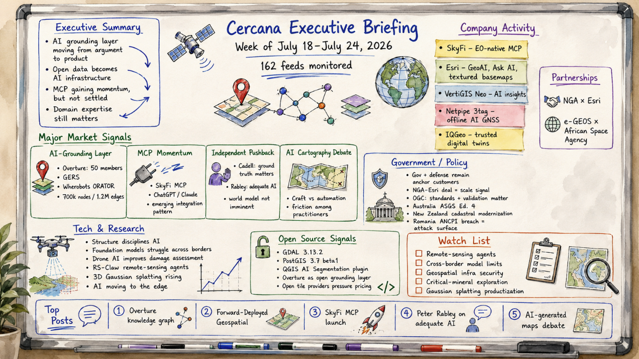
This briefing is an AI-generated, human-edited summary of 162 geospatial feeds. Published July 24, 2026.
Executive Summary
No single announcement defined the week. Across several fronts, the geospatial industry moved to build the infrastructure that could allow general-purpose AI to reason over spatial data without getting the geography wrong. The Overture Maps Foundation crossed 50 members and stated plainly what the milestone was intended to support: an open, standardized base layer for grounding AI. During the same period, Overture member Wherobots turned map geometry into a large knowledge graph designed to help language models answer spatial questions rather than guess at coordinates. SkyFi introduced a Model Context Protocol server that allows analysts to search for imagery, task satellites, and run analytics from within tools such as ChatGPT and Claude. Meanwhile, announcements following Esri’s User Conference continued to arrive, with foundation models moving further inside the dominant GIS platform and legal commentators beginning to examine the implications.
These developments suggest that the grounding layer for spatial AI is moving from argument to product. Open data was once defended primarily as a matter of principle. It is increasingly being presented as necessary AI infrastructure. MCP is gaining momentum as a common integration surface, although the market remains too early to treat that outcome as settled. Geometry is being positioned as the structure that can keep otherwise unreliable models honest.
The week also carried a strong countercurrent from people worth listening to. Will Cadell of Sparkgeo argued that domain expertise and ground truth remain the whole game, rather than details the tooling will eventually absorb. Peter Rabley cautioned against expecting a total world model on anyone’s proposed timeline. That tension is the story. The plumbing for spatial AI is being laid faster than the evidence that it can produce sustained operational value. Leaders should plan around that gap rather than assume it will close this year.
Major Market Signals
The AI-Grounding Layer Moves From Theory to Product
For the past year, the complaint has been consistent: general-purpose AI models are unreliable about place. This week, several proposed answers appeared in shippable or testable form.
Overture reached 50 members—nearly twice its 2024 count—and tied the milestone directly to using open spatial data and its Global Entity Reference System, or GERS, as a standardized substrate for grounding AI. Alongside it, member Wherobots published ORATOR, a prototype that generated approximately 700,000 nodes and 1.2 million edges across the San Francisco Bay Area. The project tested a specific proposition: map geometry can act as the common key connecting otherwise separate data themes.
Language models handle text well but remain unreliable when reasoning directly from coordinates. A verifiable spatial graph gives them structured relationships against which their answers can be checked. This is the open-data conversation arriving where it was probably always headed: openness justified less as ideology than as an efficient way to provide models with reliable geography.
For vendors, the uncomfortable implication is that control of the authoritative base layer may begin to matter more than control of the application sitting above it.
MCP Gains Momentum as a Geospatial Integration Pattern
SkyFi’s launch of a Model Context Protocol server makes imagery search, satellite tasking, and analytics directly accessible from ChatGPT, Claude, and other agent environments. It is one of the clearest indications yet that MCP is gaining momentum as a connector between geospatial capabilities and general-purpose AI.
The launch follows several months of experimentation involving QGIS, ArcGIS, geocoding services, and Esri’s efforts to expose location services and an “Ask AI” documentation assistant. Together, these developments suggest that MCP is becoming an important part of the emerging integration landscape, although it is too early to know whether it will become the dominant approach.
The significance is primarily competitive rather than technical. As imagery providers and analytics engines become accessible through common agent interfaces, the interface itself may become less distinctive. Competitive weight would then shift toward data quality, tasking access, reliability, and the domain logic behind the analytics.
Expect more “MCP for X” announcements over the next several quarters. The ones worth watching will expose meaningful operational capabilities rather than place a thin conversational layer over an existing API.
Credible Independents Push Back on the Hype
The strongest independent writing this week challenged the enthusiasm surrounding rapid productization.
In “Forward-Deployed Geospatial,” Cadell describes a recurring pattern: a company decides Earth observation has finally become accessible, hires one or two data scientists, gives them AI tools, and waits for insight to emerge. The approach works briefly. Then cloud cover compromises the archive, ground truth proves expensive and scarce, and the domain knowledge carried by experienced remote-sensing practitioners turns out to be the central requirement rather than an implementation detail.
Rabley, speaking after GeoIgnite, offered an “adequate AI” framing and warned that a total world model is not imminent, even as he argued that Canada has a meaningful strategic opportunity to act.
Neither is a reflexive skeptic. Both have been among the sector’s clearest thinkers on cloud-native infrastructure, data, and strategy. When they arrive at similar cautions during the same week, it suggests that the market may be maturing toward a harder buyer question: not what the technology can demonstrate, but what it can reliably deploy.
A Fault Line Opens Over AI-Generated Cartography
Generative AI reached further into the craft of mapmaking this week, and the cartographic community did not respond quietly.
The Map Room published a blunt defense of opposition to generative AI in cartography, responding to prominent cartographers who had characterized critics as gatekeepers or Luddites. During the same period, John Nelson and Esri published techniques for creating textured basemaps with AI.
The dispute is not primarily about any single technique. It concerns whether cartographic judgment is a craft to be protected or a workflow to be automated.
For platforms investing in generative features, the debate offers an early indication of where adoption friction may emerge. Awkwardly, it appears strongest among the expert practitioners best equipped to demonstrate the tools effectively.
Notable Company Activity
Product Releases
- SkyFi: Launched the SkyFi Model Context Protocol, allowing users to search imagery archives, task new captures, and run analytics in natural language from the AI tools they already use. It is the first prominent EO-native MCP endpoint.
- Esri: Continued its post–User Conference release cadence with GeoAI material, including guidance on selecting imagery resolution for geospatial AI models, an “Ask AI” documentation feature in the Developer’s Lounge, and techniques for producing AI-textured basemaps through the Vector Tile Style Editor.
- VertiGIS: Introduced additional AI-driven insights in VertiGIS Neo, moving analytics further into its enterprise GIS stack.
- Netpipe: Released 3tag, described as the first integrated standalone GNSS surveying system to combine RTK, pole-free laser height compensation, offline AI, and on-device reporting. It is a concrete example of inference moving from the cloud onto field hardware.
- IQGeo: Argued that autonomous telecommunications networks depend on trusted digital twins, positioning its network-model data as a prerequisite for operational automation.
Partnerships
- NGA × Esri: The National Geospatial-Intelligence Agency signed a multiyear contract to deploy ArcGIS across the organization worldwide. It represents a significant enterprise commitment from the anchor customer in the defense and intelligence segment.
- e-GEOS × African Space Agency: e-GEOS led training for the newly established African Space Agency through an Africa–European Union space-cooperation program, extending European Earth-observation engagement into a comparatively underserved market.
Membership and Ecosystem
- Overture Maps Foundation: Reached 50 members across technology, government, academia, and nonprofit organizations, with participants standardizing around open spatial data and GERS identifiers.
Government and Policy Developments
Public-sector activity reinforced one of the geospatial industry’s oldest realities: government and defense remain its most visible and reliably funded customers.
The NGA–Esri agreement is conventional in category but unusual in scale. Extending the dominant commercial platform across an entire intelligence agency illustrates how deeply proprietary GIS remains embedded in national-security workflows, even as open alternatives continue to mature.
In St. Louis, Saint Louis University announced a next-generation geospatial center. Viewed alongside Project Geospatial’s examination of the Colorado Front Range space-technology ecosystem, the announcement points to continued regional clustering of GEOINT talent, investment, and institutional capacity around major anchor organizations.
The less visible infrastructure and standards work may be more consequential for the AI-grounding ambitions described above. The Open Geospatial Consortium concluded its integration series with an examination of structured, standards-based data and validation—the unglamorous plumbing that determines whether a usable knowledge graph can be built in the first place.
Australia published Edition 4 of the Australian Statistical Geography Standard, while an official report praised New Zealand’s modernization of the Landonline cadastral system. Both developments are reminders that national spatial data infrastructure represents a slow-moving, high-stakes market that rarely generates prominent headlines.
A reported breach of Romania’s ANCPI cadastral agency provides the counterpoint. National geospatial infrastructure is increasingly an attack surface, not merely a reference layer.
Fulcrum’s analysis of the EPA water-infrastructure funding push also illustrates how federal spending programs translate downstream into demand for field operations, inspections, and asset data.
Technology and Research Trends
The broader direction is toward disciplining AI with structure rather than replacing structure with AI.
The Overture and Wherobots knowledge-graph work makes geometry the connective tissue for machine reasoning. Esri’s foundation-model integration brings the models inside an established platform, where structured data and familiar GIS controls can constrain their operation.
Beneath that productization is a quieter and more candid research signal. The Spatial Edge reported that foundation models struggle to generalize across national borders, that drone-based AI can improve fine-grained post-disaster damage assessment, and that agent frameworks such as RS-Claw are being developed to streamline remote-sensing tool selection.
A field that is deploying models while learning their limits is healthier than the demonstrations alone might suggest. Cross-border generalization failure is precisely the kind of finding that distinguishes production readiness from a compelling screenshot.
Two additional threads advanced during the week.
Gaussian splatting and 3D reality capture continued to move from novelty toward routine application, with VerySpatial examining practical adoption of 3D Gaussian splatting relative to traditional photogrammetry.
AI also continued migrating toward the edge. Netpipe’s offline-AI GNSS unit is a small but tangible example of inference operating directly on a field device, an important capability for surveying, emergency response, and defense work conducted in connectivity-constrained environments.
Open-Source Ecosystem Signals
The open-source core continued its steady release cadence.
GDAL released version 3.13.2, while PostGIS published its 3.7.0 beta 1 release. These foundational libraries quietly support many of the commercial products and workflows discussed elsewhere in this briefing.
Within the QGIS ecosystem, an “AI Segmentation” plugin brought deep-learning object detection for aerial imagery into the plugin interface. Spatialists also highlighted a QGIS specialist module for cadastral surveying. The AI-in-GIS story is developing in open tooling alongside the major proprietary platforms.
The signal with the longest potential reach remains Overture. A 50-member foundation positioning an open base layer as grounding infrastructure for commercial AI raises governance and sustainability questions that belong on the executive agenda. A growing share of the industry’s AI ambitions may depend on this layer.
Maps Mania’s review of free tile providers—including OpenFreeMap, VersaTiles, and Maptoolkit—represents a smaller version of the same trend, placing further pressure on proprietary basemap pricing.
These developments indicate a healthy ecosystem, but they also concentrate dependency. More of the commercial geospatial stack rests on a relatively small number of open projects and foundations whose funding, maintenance, and governance rarely receive scrutiny proportional to their importance.
Watch List
- Remote-sensing agents, including RS-Claw: Early frameworks are emerging for agents that select and orchestrate remote-sensing tools. This moves the agentic AI discussion beyond the GIS desktop and into the Earth-observation analytics pipeline.
- Cross-border model-generalization failure: Research showing that foundation-model performance degrades across countries is a load-bearing caution for organizations purchasing supposedly global geospatial AI. Watch for vendors to begin disclosing geographic performance boundaries.
- Geospatial infrastructure as an attack surface: The reported ANCPI cadastral breach points to a security dimension of national spatial data infrastructure that the market has largely overlooked.
- AI and GIS in critical-mineral exploration: Canadian coverage surfaced a comparatively rare commercial-vertical use case in mining. It is worth tracking as a demand-side signal from a segment that is usually difficult to observe.
- Gaussian-splatting productization: 3D Gaussian splatting is moving from experiment toward routine reality-capture workflows. A corresponding market for tools, integration, and services is beginning to form.
Top Posts of the Week
- From Concept to Prototype: Grounding AI & LLMs with Overture’s Cross-Theme Knowledge Graph — Overture Maps Foundation
The clearest technical expression of the week’s dominant theme: geometry as the verifiable common key for grounding AI-based spatial reasoning. - Forward-Deployed Geospatial — Sparkgeo
Will Cadell’s counterweight to the hype: domain expertise and ground truth remain central requirements, not details AI tooling will absorb. - SkyFi Launches MCP to Connect Satellite Imagery and Geospatial Analytics to ChatGPT, Claude, and AI Agents — Earth Imaging Journal
The first prominent EO-native MCP endpoint and an indication that the integration surface for spatial AI may be beginning to converge around a common protocol. - Peter Rabley on the Total World Model, Adequate AI, and Canada’s Window — GoGeomatics
A measured “adequate AI” perspective connecting the world-model debate to questions of national capacity and technological sovereignty. - Gatekeepers, Luddites, Haters and AI-Generated Maps — The Map Room
A direct statement of the cultural fault line emerging in cartography over generative AI and an early indication of adoption resistance among expert practitioners.
Cercana Executive Briefing is generated from 162 feeds aggregated by geofeeds.me.