
Week of July 11–17, 2026. Published July 17, 2026. Sourced from the geofeeds ecosystem and open web reporting.
Executive Summary
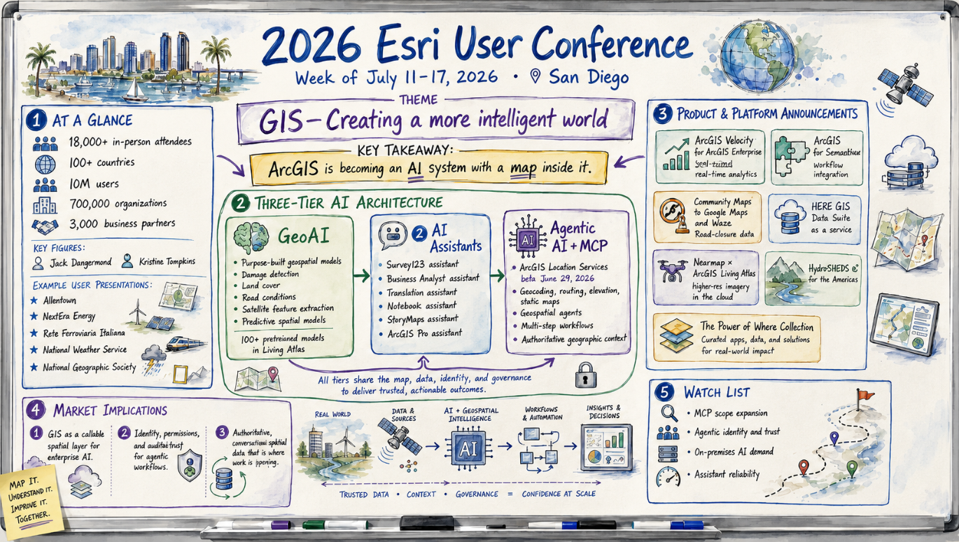
The 2026 Esri User Conference, which closes today in San Diego, made one case over and over: ArcGIS is turning into an AI system with a map inside it. Under the theme “GIS—Creating a more intelligent world,” Esri used its largest annual gathering, which drew more than 18,000 in-person attendees from over 100 countries, to pull together a three-tier AI strategy it has been assembling in public since the spring. The tiers cover purpose-built geospatial models, embedded natural-language assistants, and the piece that matters most, agentic AI backed by Model Context Protocol (MCP) support.
What should hold an executive’s attention is the repositioning rather than any single feature. By exposing ArcGIS location services through MCP, Esri makes its authoritative spatial data and analytics callable by outside AI agents. GIS stops being a specialist tool that GIS professionals operate and becomes a spatial layer any enterprise AI system can invoke on demand. That shift matches the week’s broader market signal, visible across the wider geospatial press: open, authoritative, machine-readable geographic data is becoming the ground AI is built on. The strategy also showed up in shipping product, not just slides. During the same week Esri released real-time analytics for self-hosted deployments, an enterprise-workflow integration with ServiceNow, and several new data partnerships.
The Conference at a Glance
The conference ran July 13–17 at the San Diego Convention Center, which Esri bills as the world’s largest GIS gathering. Jack Dangermond, Esri’s president and founder, delivered the plenary vision. He was joined by keynote speaker Kristine Tompkins, a conservationist, former CEO of Patagonia, and cofounder of Tompkins Conservation, whose rewilding work gave the “intelligent world” theme an environmental cast. Plenary user presentations covered a wide slice of operational GIS: the City of Allentown, Pennsylvania; NextEra Energy; Italy’s rail infrastructure manager Rete Ferroviaria Italiana; the National Weather Service; and the National Geographic Society. Esri put its installed base at more than 10 million users across over 700,000 organizations, backed by more than 3,000 business partners. Those are the numbers behind its platform ambitions.
The Dominant Theme: Agentic AI and a Three-Tier Architecture
Most accounts of the week came back to AI, and specifically to a three-tier architecture Esri has been describing since its spring developer summit.
The first tier is what Esri calls GeoAI: purpose-trained models embedded in ArcGIS for specifically geographic tasks. These include detecting building damage in post-disaster imagery, classifying road or land-cover conditions, extracting features from satellite data, and running predictive spatial models. They are fine-tuned machine learning and deep learning models, not general-purpose LLMs pressed into mapping duty, and more than 100 pretrained versions now ship through ArcGIS Living Atlas of the World.
The second tier is AI assistants, natural-language helpers embedded across ArcGIS apps. Three reached general availability in the June 2026 release at no additional cost to user types: the Survey123 assistant, which turns a plain-language description into a deployable data-collection form; the Business Analyst assistant, which recommends spatial workflows in response to business questions; and a translation assistant for multilingual content. Others sit in preview or beta, including a Notebooks assistant that generates and troubleshoots Python, a StoryMaps assistant that converts PDFs into draft narrative maps, and an in-app ArcGIS Pro assistant for writing Arcade expressions.
The third tier, agentic AI, carries the most weight. It builds on MCP support for ArcGIS Location Services, released in beta on June 29, 2026 and initially covering geocoding, routing, elevation, and static-map rendering. On that base, Esri is building geospatial agents that read maps, layers, and structured spatial data, and that can run multi-step workflows on their own rather than simply answer questions. Esri’s argument is that these agents stay anchored in authoritative geographic context, where generic agents tend to produce spatial answers disconnected from the real world. The payoff is reach. MCP lets non-GIS enterprise agents call ArcGIS capabilities directly, pushing location intelligence into tools that never had GIS expertise behind them.
Product and Platform Announcements
Alongside the AI narrative, a steady run of product news moved through the trade press during the conference week.
ArcGIS Velocity for ArcGIS Enterprise. Esri made its real-time data ingestion, analytics, and automated-alerting engine available for self-hosted ArcGIS Enterprise, unifying real-time workflows across Online and Enterprise. The significance is deployment flexibility: organizations that cannot move data to the cloud can now run real-time GIS behind their own firewall.
ArcGIS for ServiceNow. A new integration connects ArcGIS with ServiceNow’s enterprise workflow platform, pushing location intelligence into everyday operational systems across commercial, government, healthcare, utilities, energy, and telecom sectors. It is a case of Esri meeting users inside the software they already run instead of asking them to come to a GIS.
Community Maps to Google Maps and Waze. Esri expanded its Community Maps Program so ArcGIS users can feed real-time road-closure data straight into Google Maps and Waze. More than 100 communities already contribute authoritative closure information, which puts public agencies upstream of the consumer navigation apps most drivers actually use.
HERE GIS Data Suite as a service. HERE’s foundational mapping data became available through a data-as-a-service model that connects directly into ArcGIS environments, cutting the infrastructure burden of maintaining base data.
Nearmap × ArcGIS Living Atlas. Esri selected Nearmap as the exclusive high-resolution aerial-imagery basemap provider for Living Atlas, widening distribution of Nearmap’s built-environment imagery through Esri’s platform.
HydroSHEDS v2 for the Americas. Esri and global partners released an updated hydrological dataset, adding to Living Atlas as a repository of authoritative scientific base data.
The Power of Where Collection. A new publishing collection that extends Dangermond’s 2024 book into applied water- and land-management cases. It is the evangelism side of the program.
What It Means for the Market
Three implications stand out, whether or not you run Esri.
First, the competitive question for enterprise GIS is moving from “which platform makes the best maps” to “which platform is easiest for AI to call.” Esri’s MCP bet is that the position worth holding is the trusted spatial layer underneath other companies’ AI agents. Vendors and buyers should expect more location intelligence to be consumed through conversational and agentic interfaces, and less through GIS software opened directly.
Second, agentic workflows raise hard governance problems that will set the pace of adoption. Partners building ArcGIS MCP tooling have flagged identity and permissions as the core issue: an agent acting for a user has to inherit that user’s specific permissions, not the organization’s full administrative access. Any enterprise weighing agentic GIS should treat identity, scoping, and auditability as requirements to clear before deployment.
Third, the run of data-as-a-service and partnership deals confirms where the value is pooling: authoritative, continuously updated base data. HERE, Nearmap, and Living Atlas’s pretrained models and scientific datasets all point the same way. Current, trustworthy, machine-ready geographic content is what makes the AI layer worth using, and this conference is where that idea hardened into a product strategy.
Watch List and Open Questions
- MCP scope expansion. The initial ArcGIS MCP beta covers a handful of location services. How quickly Esri extends MCP across ArcGIS Enterprise and Online, and how open it stays to third-party agents, will decide whether the “callable spatial layer” idea holds up.
- Agentic identity and trust. Reliable, scoped identity for agents working inside ArcGIS is an unsolved, ecosystem-wide problem. Watch whether Esri and its partners settle on a shared approach.
- On-premises AI demand. Velocity’s move to self-hosted Enterprise reflects real demand for AI and real-time capability that stays behind the firewall. It runs against cloud-only defaults and is worth tracking in regulated sectors.
- Assistant reliability. As assistants embed deeper into daily workflows, Esri itself is calling out trust and reliability of the underlying models as the next hurdle. Enterprise buyers should press on accuracy and failure modes.
Sources
From the geofeeds ecosystem:
- Esri Introduces ArcGIS Velocity for ArcGIS Enterprise — Earth Imaging Journal — Real-time analytics reach self-hosted deployments.
- Esri Introduces ArcGIS for ServiceNow — Earth Imaging Journal — Location intelligence embedded in enterprise workflow software.
- Esri Helps Bring Up-to-Date Road Closure Information to Google Maps and Waze — Geoconnexion — Public agencies as authoritative upstream data for consumer navigation.
- HERE GIS Data Suite available as a service — Earth Imaging Journal — Foundational data delivered as a service into ArcGIS.
- Nearmap to Provide Imagery for ArcGIS Living Atlas of the World — Earth Imaging Journal — Exclusive aerial-imagery basemap partnership.
- What’s New with Living Atlas Imagery – Esri User Conference 2026 — ArcGIS Blog — UC-timed imagery updates.
- Introducing the AI Assistant (Beta) on Esri.com — ArcGIS Blog — Conversational AI across Esri’s own properties.
- Esri to Debut the Power of Where Collection — Earth Imaging Journal — Applied extension of Dangermond’s 2024 book.
From open web reporting:
- 2026 Esri User Conference to Focus on Creating a More Intelligent World — Esri Newsroom — Theme, dates, keynotes, and scale.
- GIS Meets Agentic AI: Esri UC 2026 Opens in San Diego — Tech Times — The three-tier AI architecture and its strategic implications.
- The Next Era of AI and ArcGIS — ArcNews — MCP, geospatial agents, and agentic mapping apps.
- MCP Support (beta) in ArcGIS Location Platform — ArcGIS Blog — The June 29 MCP beta and its supported capabilities.
- 2026 Esri User Conference: Day 2 — IGIS (UC ANR) — On-the-ground account of AI’s dominance across sessions.
Supplemental briefing to the Geospatial Market Survey, generated from feeds aggregated by geofeeds.me and open web reporting.